METAR Code
N/A
Weather Symbol

Warm fronts can often lead to the presence of freezing precipitation (in winter), as well as embedded convection, and elevated (i.e. not surface based) thunderstorms. They provide the environment necessary for frontal fog to occur, and when coincident with the warm front, low-level jets can exacerbate associated low-level wind shear.
The boundary of an advancing warm air mass, which marks the leading edge of the warm sector of a low-pressure system.
Associated terms coming soon:
Dewpoint, inversion, and low-pressure system are all terms associated with thunderstorms that will be coming soon to the Aviation Meteorology Reference.
A warm front is created, typically in association with a developing low pressure system, when warm, often humid air is transported by the wind to a region of cooler, drier conditions.
Since this warm air enters into a region where it is relatively less dense than its surroundings, it is forced to “overrun” the cool air as it progresses. Due to their differing densities, these air masses do not mix, and warm air is forced up into the atmosphere where it cools and condenses into clouds, often generating precipitation.
This animated GIF shows an example of warm air "overrunning" cool air as it is advected by the wind. Note the long slope of the frontal surface, and where the warm front is represented at the surface relative to the location of the warm air aloft.
Image Source : Environment and Climate Change Canada
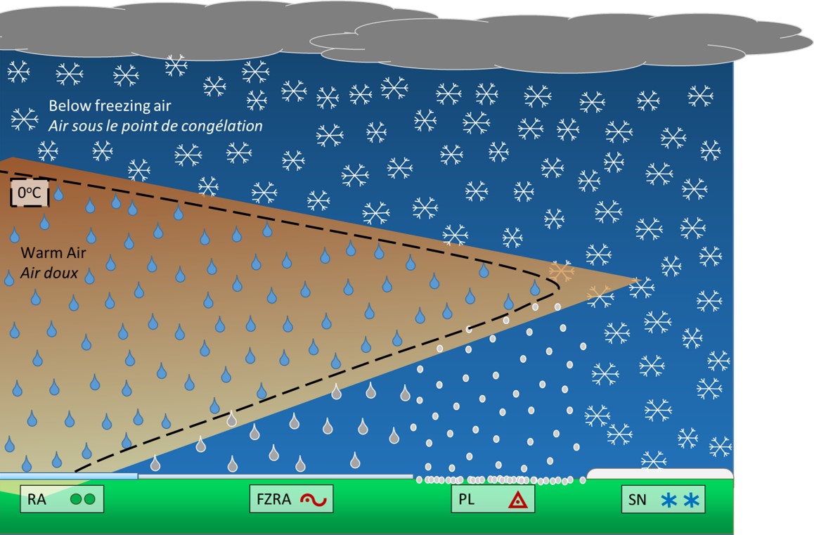
This image is an example of precipitation types with warm air advances up the warm frontal boundary. Depending on the temperature profile across the front, the depth of the warm layer, and where it sits in the atmosphere, a number of different precipitation types could be observed on the ground.
The slope of a warm front is usually shallow in comparison to a cold front, which is why stratiform clouds and areas of uniform precipitation are more commonly seen with warm fronts. Depending on the temperature profile across the frontal boundary, rain, snow or a mix is possible ahead of the front, however freezing precipitation is also possible along the front itself when the temperature profile allows for a region of warm air (near or above 0oC) to be transported into colder air ahead of the front.
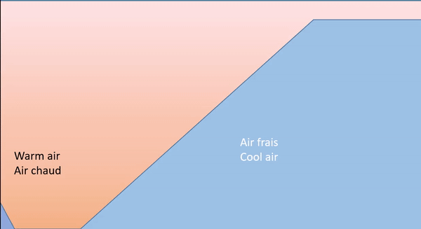
The leading edge of a warm front is identified by a wind shift that transitions from a colder, drier air mass to the warmer more moist air mass in the warm sector of a low pressure system. Warm fronts typically have a shallow slope as you increase in altitude. This leads to a wider transition zone between the colder air mass and the warm sector, and leads to the development of more stratus clouds and uniform precipitation.
Image Source: Environment and Climate Change Canada
An idealized side view of a low pressure system between the fronts, showing stratus at all levels (nimbostratus, altostratus) building on the warm frontal surface.
Image Source: Environment and Climate Change Canada
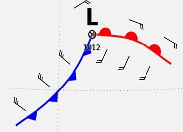
Warm fronts are characterized by their marked temperature gradients at the surface, as well as gradients in humidity (warm air is often more humid, indicated by higher dew point temperatures in the warm sector). There is also generally a distinct change in wind direction ahead of and behind the front at the surface, switching from near parallel to the front (often easterly winds), to southerly-southwesterly within the warm sector.
This image is an idealized wind flow around a low-pressure system and across the warm front.
Image Source: Environment and Climate Change Canada
Dissipation
As a low-pressure system matures it enters what is known as the occluded phase. The center of the low begins to lag behind the propagating frontal boundaries, and with that lag, the warm front loses its energy and the boundary between the warm sector and cold sector moderates. At the surface, this is depicted by the purple “occluded front”. However, in Canada we depict the trowal aloft, as it is where there is active weather. The trowal represents the top of the boundary along which cold air behind the cold front undercuts warm and ahead of the warm front. This process will continue until the fronts dissipate all together.
Warm fronts will often dissipate in tandem with their associated low-pressure system, however, they begin to change form as the occlusion phase takes place.
The warmer, less dense air generally cannot force cold air away as effectively as a cold front, which results in warm fronts moving much slower than their cold front counterparts, usually. Occlusion begins when the faster moving cold air behind the cold front “catches up” and begins to dig underneath the warm front, forming a trowal.
Duration
Warm fronts generally last as long as a low-pressure system is in the development and maturing phases, which can be several hours or a few days.
Image Source: Environment and Climate Change Canada
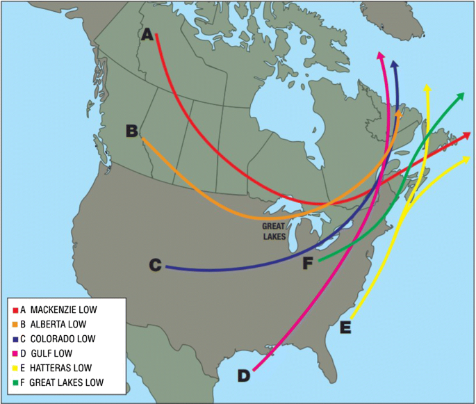
This graphic depicts the typical low cyclogenesis and their typical tracks across North America. Low pressure systems will retain similar characteristics based on their origin as well as the season, which will in turn affect the behaviour of the warm front associated with the low.
A warm front part of a low from Colorado, the Gulf, or Hatteras is most likely to be associated with freezing precipitation and higher precipitation rates as the warm air is most often stemming from a Maritime Tropical air mass. This air mass has high water content and warm temperatures that fuel both the warm air needed aloft for freezing precipitation and moisture to produce higher amounts of precipitation.
The intensity of warm fronts and their associated weather are in large part connected to multiple different atmospheric processes. The most important thing to mention is seasonality. Shoulder seasons (fall/early winter and late winter/early spring) often bring the most intense storms across the country.
Image Source: SpringerLink
The timing of a warm front can be challenging as small changes in the speed and direction of the air masses can change the arrival of a warm front. It can often happen that the warm front changes speeds as it moves forward, as it is not as effective at moving cold, dense air out of the way. This in turn can affect the surface temperature forecast and therefore precipitation phase changes, the strength of the winds associated with the front as well as the timing of the wind shift associated with the approaching front.
Precipitation typing can pose challenges as well, especially in the shoulder seasons (fall and spring) when surface temperatures are hovering around the freezing mark. The exact timing of the transition between rain and snow is often difficult and dependent on a variety of factors. While forecasters can observe the shape of the frontal surface by way of upper air soundings and tephigrams, the observation network density is not high enough in spare or time to get real time data. When the depth or temperature of the warm air intruding into cold air over the frontal surface is different than model forecasts, it can make the difference of adding or entirely removing freezing precipitation from a forecast. In this case, AMDAR readings are immeasurably valuable to the forecasters on desk to give more information about the air temperature profile, as well as PIREPs confirming the presence or absence of freezing precipitation.
Finally, cloud cover associated can cause difficulties while forecasting. As the warm front advances, broad cloud coverage blocks the forecasters’ view of processes happening near the surface. It more data-sparse regions such as Northern Canada, as the observation network is not necessarily dense enough to capture all phenomena occurring at the surface.
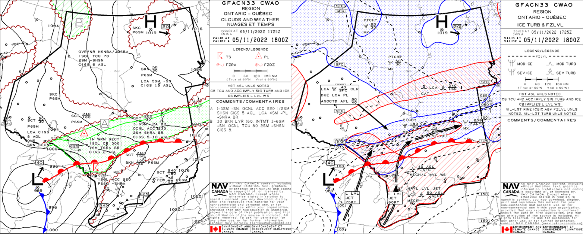
This low is approaching maturity and has well defined warm and cold fronts. In this stage it is usually easier to find a front’s location by looking for the surface trough across isobars (contours of equal pressure). The warm front here is draped across central-northern Ontario into central Quebec, from Sault Ste-Marie (CYAM) to Bagotville (CYBG).
Weather associated with this warm front:
Clouds and Weather
Icing and Turbulence
Two potent low-level jets at 60KT and 75KT, with associated risk of local severe mechanical turbulence and wind shear in two regions. One from the surface to 5000ft AGL over southern Ontario/southern Quebec, and the Great Lakes, the other further aloft from Lake Huron/Marathon (CYSP) to Matagami (CYNM).
Ahead of the warm front there is a local risk for severe clear icing associated with the indicated AFL (above freezing layer) between 4000ft and 8000ft ASL and associated ice pellet precipitation type, as well as patchy moderate mixed icing from 3000ft to 18,000ft ASL.
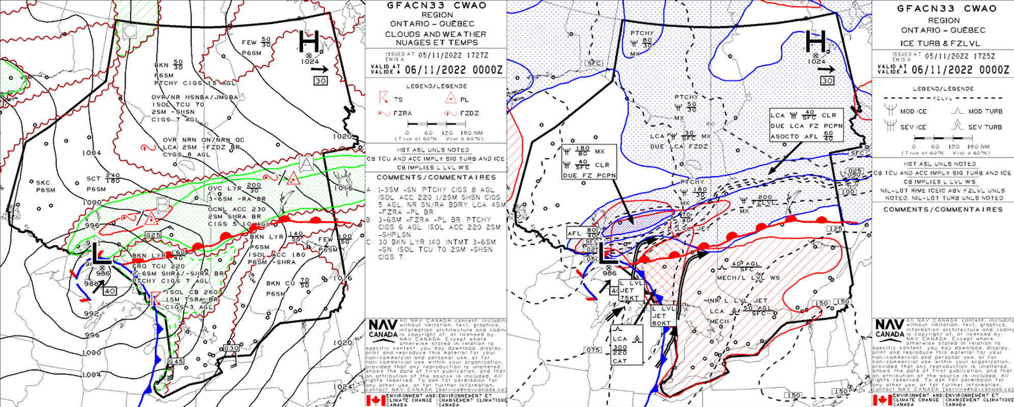
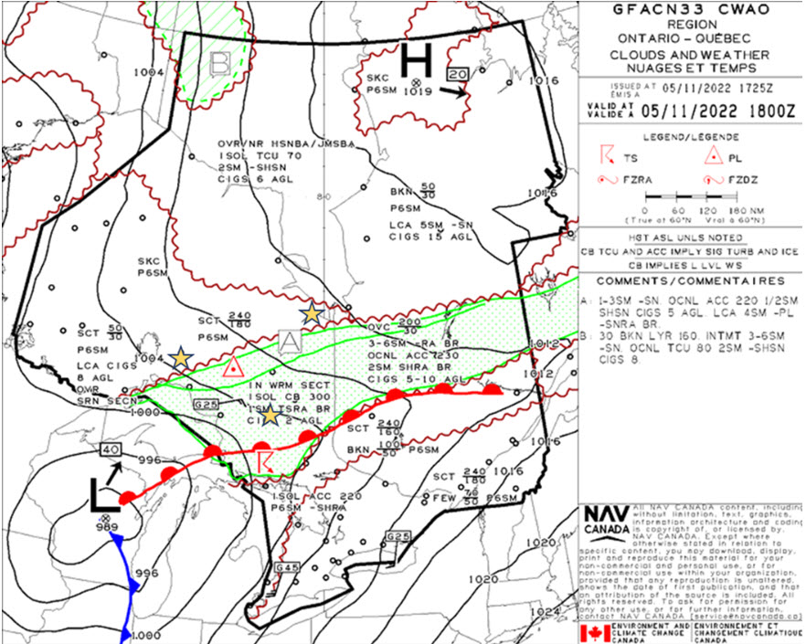
These are the T+06 GFA panels, valid six hours later for the same event. The low has started to occlude, which in Canada is defined as a trowal.
Clouds and Weather
Ahead of the warm front, one notable change is the addition of a red hatched zone of freezing precipitation in the clouds and weather, indicating an area of more organized freezing precipitation.
Icing and Turbulence
The tightly blue hatched area represents the area of organized severe clear icing, once again from the surface to the base of the AFL at 4000 ft ASL. The jet more eastward of the low’s center has also intensified, with both jets magnifying the intensity of the warm-air advection aloft.
The hatched black lines indicating freezing level altitude (in 1000 feet ASL) are often bunched together in the vicinity of fronts when two contrasting air masses interact.
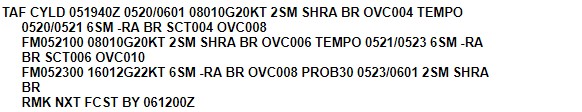
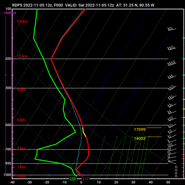
Legend: Three TAFs along/ahead of three different regions of the front and its forecast movement – Geraldton (CYGQ), Chapleau (CYLD), and Moosonee (CYMO).
At the time of this forecast, Chapleau (CYLD) is located in the organized precipitation zone just ahead of the warm front, with occasional convective showers and CIGS in the 500ft-1000ft AGL range.
There is a gradual improving trend in the TAF:
Moosonee (CYMO) is just outside of the main precipitation area at the time of issuance of this TAF. As opposed to CYLD, whose conditions have an improving trend to them, CYMO is forecast to deteriorate over the next 12hrs as the front approaches.
Freezing levels in the GFA examples under the icing/turbulence images provide a rough estimate of the likelihood of seeing snow on the ground without having to look at vertical soundings.
Geraldton (CYGQ) is the TAF that is farthest west of all examples. Though there is precipitation and freezing precipitation in the forecast that is associated with the warm front, CYGQ is forecast to remain north and west of the front’s surface boundary. Let’s see how we can tell this:
Conditions are forecast to worsen as the lobe of precipitation associated with the warm front approaches.
Conditions are forecast to slightly improve as winds back to the N, albeit only marginally.
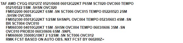
This is a vertical profile of temperatures, dewpoints, and winds from Geraldton (CYGQ) from November 05 at 1800Z to November 06 at 0600Z (12hrs). Putting the three together show a telltale pattern of the warm front’s trajectory.
Image Source: Pivotal Weather
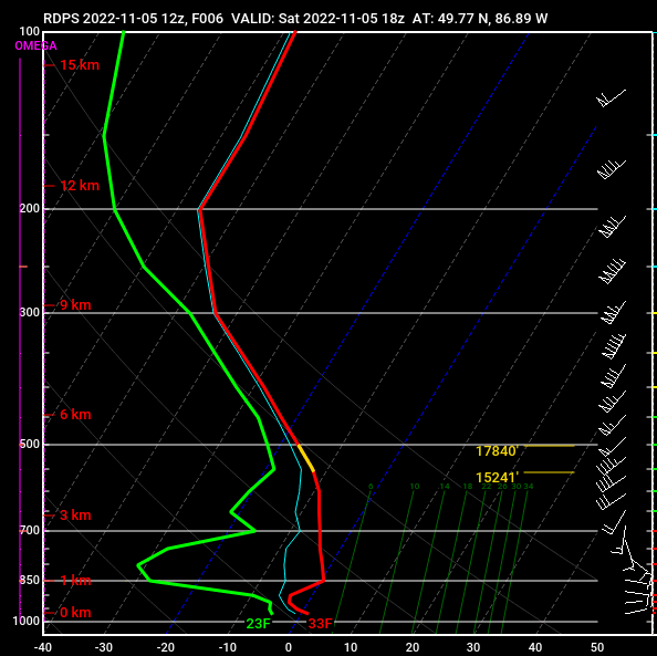
This is a vertical profile of temperatures, dewpoints, and winds from CYMO from November 05 at 1200Z to November 06 at 0900Z (18hrs). CYMO saw the approaching warm front and had the surface boundary cross over the station. Similar profiles exist to what occurred at CYGQ with a few start contrasts:
Winds after the frontal passage are unidirectional, SWLY throughout the column.
Image Source: Pivotal Weather
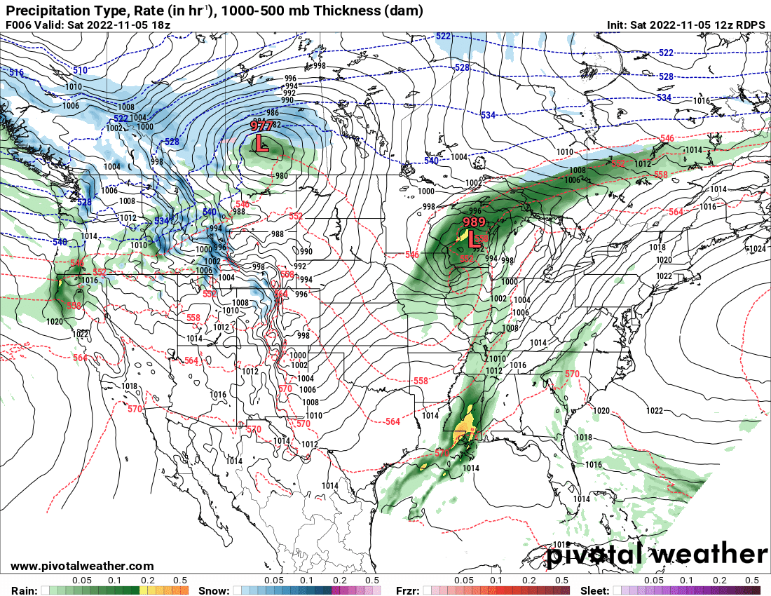
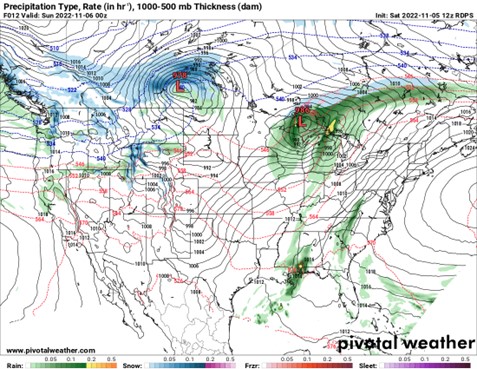
This is a model run of the RDPS high-resolution model, initialized November 5 at 1200Z and valid at 1800Z.
Image Source: Pivotal Weather
This is a model run of the RDPS high-resolution model, initialized November 5 at 12000Z and valid at 0000Z, six hours after the first image shown.
Image Source: Pivotal Weather
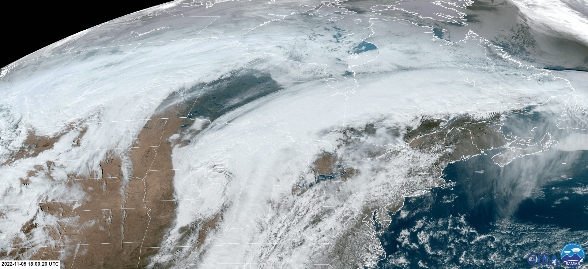
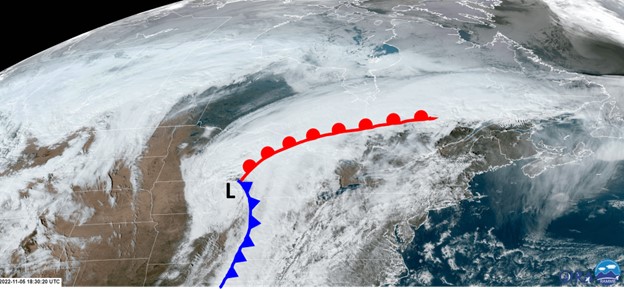
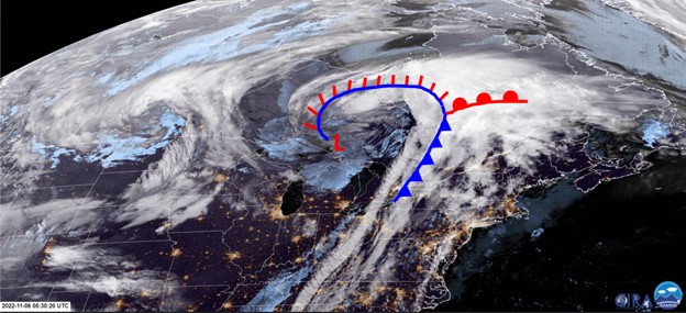
This satellite image loop from 1800Z on November 5 to 0600Z on November 6 shows the low-pressure system and its associated fronts propagating across the Great Lakes region.
Image Source: CIRA
The low is in the beginning stages of occlusion.
As shown in the 1800Z GFA, the warm front extends from the low’s center across north-central Ontario and into central Quebec.
Image Source: CIRA
By 0600Z on November 6, the low is in late stages of occlusion. This nighttime Infrared (IR) imagery allows for us to differentiate between high and low-level clouds as well. High cloud tops are white, low level clouds blue. Note: high cloud tops do not differentiate between cirrus clouds and stratus/convective clouds.
Image Source: CIRA
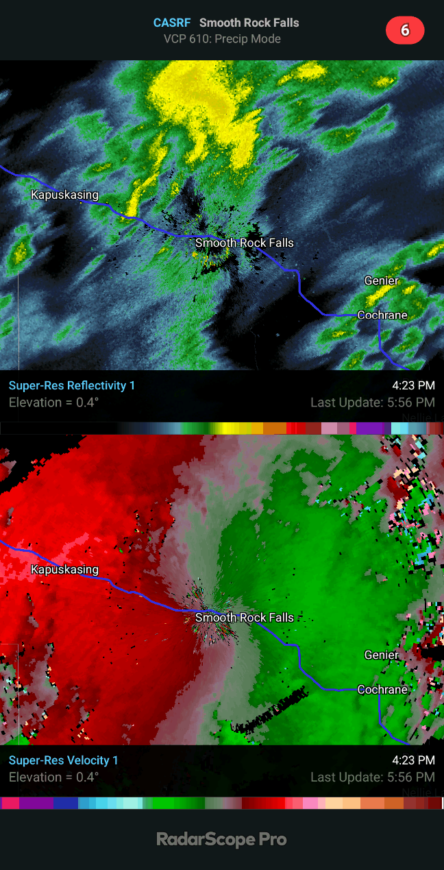
This radar image taken from Smooth Rock Falls, just East of CYYU (Kapuskasing), includes both reflectivity (top panel) and ground-based velocityOpen a new window (bottom panel).
Image Source: RADARSCOPE
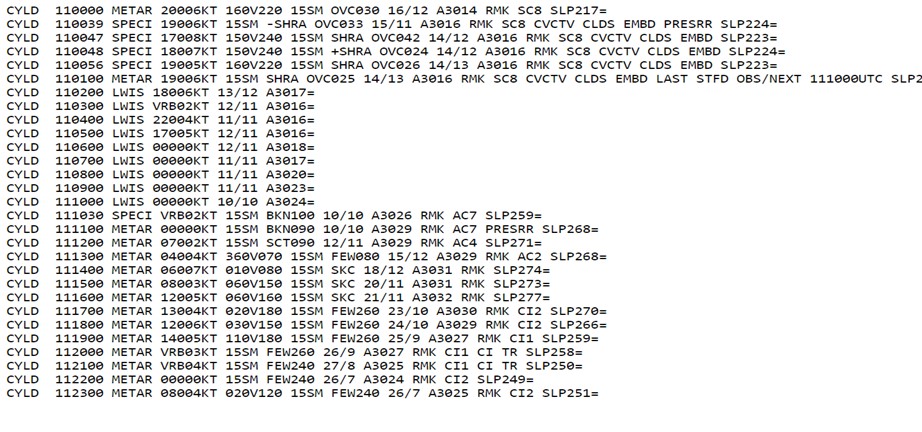
CYLD METARs provide a great glimpse of the passage of a warm front:
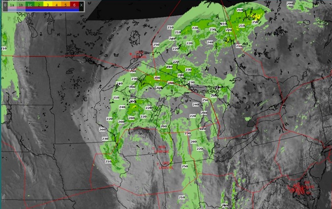
CoSPA is a wonderful tool to assess the presence of potential convection throughout a large area of precipitation.
In the GFA there was mention of occasional ACC to FL220 (Flight Level), and throughout much of the Great Lakes/Northern Ontario region we see that indeed this is the case.
Image Source: CoSPA (MIT Lincoln Lab)
Loss of lift due to icing conditions, turbulence associated with embedded convection/presence of a low-level jet, loss/gain of speed/altitude in low-level windshear conditions, variable visibility/ceilings in presence of frontal fog, potentially hazardous runway surface conditions due to precipitation.
Airport Authority takes cues from the weather forecast if further actions would be warranted such as deployment of surface anti icing chemical or staffing resources to support operations. We would be looking for weather warnings / alerts or anything in our weather forecast resources that indicate conditions of risk such as freezing rain, freezing fog, significant rainfall or other weather phenomena of interest that affects airport operations.
Operations Duty Managers
The term on its own does not impact operational decisions. The weather associated with a warm front or upper-level warm front is the consideration.
Seeing these terms in a forecast most often leads to more questions:
Other than sparking questions, the actual terms would not prompt any action other than request for addition information.
ATC (Regional Tower)
Regional towers VFR controllers will assess warm front risks including freezing rain, freezing drizzle, snow, and all possible fog (advection fog, radiation fog, ice fog) as this can impact both general aviation and commercial aircraft significantly.
Like cold fronts, the effect of warm fronts of FSS ops is quite seasonal in variation. Summer warm fronts certainly bring widespread rain and lower ceilings for VFR operations but fall and winter make for more freezing precipitation and snow, and greatly increase the threat to aviation safety that these phenomena present to all our customers. Wind shifts associated with a warm frontal passage combined with local effects can also turn what would be low but acceptable VFR ceilings and visibilities into Reduced or Low Visibility Operations in a very short amount of time with little warning, especially in the winter months. Warm air can also ride up over colder air in valleys, and lead to localized pockets of (often significant) freezing precipitation where weather observations and PIREPs aloft in the area are reporting rain (a common problem in Fredericton for example).
FIC
When presenting information in a weather briefing, synoptic features such as a warm front are referred to initially to explain the strategic view of weather effects. Once the briefing moves into detail around departure point, enroute track and destination weather at ETA, a specialist will touch on actual and forecast local conditions, using the synoptic feature to explain the source of these anticipated conditions. This will influence the pilot’s choices in whether or not they go, what route and altitude they will take enroute, how much fuel they will need to perform the flight safely – this alone might cancel the flight, if the prevailing wind aloft is unfavorable, as the required fuel burn may exceed the amount of gas the airplane can carry.
The type of synoptic feature informs the general conditions, subject to seasonal and diurnal effects, that can be expected. This is where the Flight Service Specialist working in a FIC really earns their pay, using their knowledge of meteorology in conjunction with their expertise in the unique factors contained in their FIC’s Area of Responsibility. Due to the dynamic nature of the aviation environment, no two briefings will be exactly the same.
AAS
Advisory specialists will monitor the approach of a warm front by watching the progression of clouds from high cirrus down through the levels as the front approaches, in concert with watching the weather radar and maintaining a weather watch on sites upstream. Specialists might also check the GFAs and contact the FIC for more information if required. The front is closely lead by low ceilings and precipitation, as well as a reduction in the temperature dewpoint spread. Frontal passage is accompanied by a wind shift towards south/southwesterly winds, a drop in pressure, and a gradual increase in the ambient temperature as well.
The term as a stand-alone doesn’t have an impact on low-level controllers.
It is when the front is associated with the presence of freezing precipitation that there is a major impact on flight.
Warm fronts with a low-level jet or low-level wind shear can significantly impact our operations.
Heavy rain may cause smaller aircraft to overshoot or cancel their approaches in regional airports.
In the case of freezing precipitation, regional airports often close for long periods (many hours to more than a day) as the runway becomes unusable.
Precipitation can cause a lot of complexity for ATC.
When airport closures occur in major airports, it is better to hold jet aircraft as high as possible to minimize fuel burn.
A warm front generally implies messy weather systems with low ceilings/visibility and precipitation. The summer version of a warm front increases the risk of associated thunderstorms while winter warm fronts are associated with icing risks due to freezing precipitation.
A summer warm front tends to generate unorganized thunderstorms that are more challenging to forecast than a cold front for example.
Winter warm fronts are some of the most challenging weather conditions that airlines face due to varying types and severity of freezing precipitation.
Adjustments of commercial schedules are treated in a similar manner to snow- a consensus in multiple weather forecasting products/resources is needed prior to initiating weather cancellations.
Seasonality will matter when evaluating the impact of a warm front on the operations, mainly the weather associated with its presence. Also, keeping an eye on frontal passage against the TAF for a wind change driving a runway change.
Summer
The impact of a summer warm-front passage will be low for overseas operation.
Typically, pilots will see rain, lower visibility and lower ceilings, which are dealt with easily at major airports.
Winter
We start expecting a mix of precipitation, especially freezing precipitation. The TAF will be our reference for the start of the different precipitation types. For departure, pilots expect to add on more fuel for a very long taxi-out time.
If the warm front has a risk of freezing precipitation, the same threats and precautions for a snowstorm apply when encountering freezing precipitation for departure.
For an alternate airport, it becomes more relevant to avoid freezing precipitation in a forecast.
Icing is a common hazard associated with warm fronts. In freezing precipitation, we will encounter supercooled large water droplets (SLD), yielding icing which is beyond what is flight tested during certification.
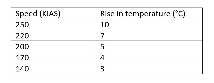
One aspect of jet aircraft is kinetic heating of the air due to their airspeed and can impact icing. As the air flow hits the leading edge of the wing, its temperature rises at the point of impact, where icing would normally accumulate. That temperature, at the point of impact, is called the Total Air Temperature (TAT).
IFR pilots are primarily concerned with the classic winter warm front and the possible effects of freezing rain/drizzle for airport operations/immediate departure until they are up and away from the freezing rain.
High level Enroute - This is the phase of the flight where pilots review our initial plan
Warm fronts bring varying degrees of precipitation, of which the main concerns VFR GA (General Aviation) pilots are freezing precipitation and visibility.
In warmer temperatures, rain will almost always affect visibility to a certain degree.
Freezing precipitation for VFR GA must be avoided at all costs.
As temperatures get colder, icing at altitude also becomes an issue.
Winter warm fronts bring another mix of precipitation most of which can create an icing risk.
When planning a flight based on the forecast, most GA pilots will want to avoid freezing rain by a good margin and even wet snow when they are aware of the associated risks.
From a general aviation/floatplane pilot perspective flying decisions would be driven by the forecast precipitation around the front. Most of the VFR pilots don’t want to fly in the rain, low cloud, poor visibility etc. and depending on what was going on at the boundary of the front would likely not go flying.
For upper-level warm fronts, most VFR GA pilots don’t fly above 10k feet ASL and thus don’t often consider the effects of upper-level fronts. While we do recognize that the weather aloft will have an impact on the weather below, these concepts are poorly understood and therefore usually not considered by us.