METAR Code
PL
Weather Symbol

Ice pellets primarily cause slippery surfaces and reduced traction for aircraft and vehicles. The accumulation of ice pellets on surfaces makes it difficult to maneuver (accelerate and decelerate) and can lead to a risk of accidents.
Additionally, ice pellets may cause reduced visibility, especially when accompanied by snow and freezing rain. The presence of ice pellets is indicative of an above/near freezing layer in the mid levels, and that other forms of precipitation such as freezing rain, rain or snow are likely also present, which carry their own associated hazards.
Ice pellets, also known as sleet, is precipitation that consists of small, translucent or opaque pieces of ice. Ice pellets are composed of frozen or mostly frozen raindrops, or refrozen, partially melted snowflakes with a diameter typically less than 5mm.
Associated terms coming soon:
Cold air damming, inversion, low-pressure system, and wind channeling are all terms associated with ice pellets that will be coming soon to the Aviation Meteorology Reference.
Ice pellets require a specific atmospheric profile in order to occur:
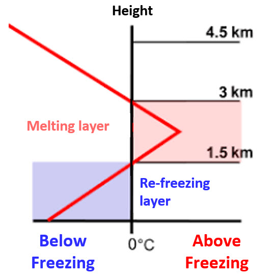
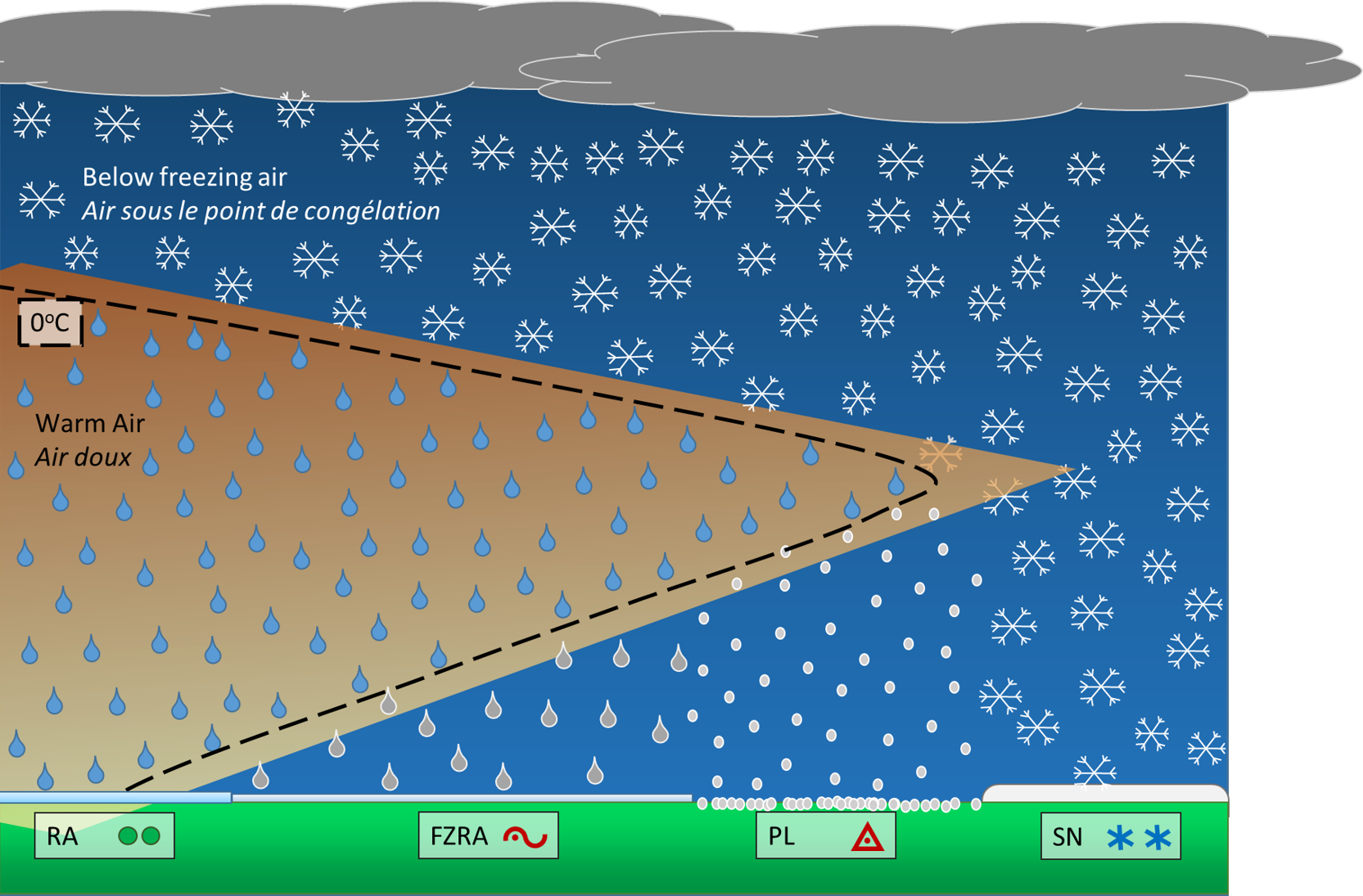
When precipitation develops, it starts in the form of snow or ice crystals. In typical, wintry conditions, this snow reaches the surface intact. In cases of ice pellets (PL), it encounters a layer of warm air that is near or above 0°C as it falls, and if this warm layer is sufficiently thick, the snow will melt completely into rain. When the rain then encounters a surface layer of colder air, with temperatures below 0°C, the droplets’ temperatures will dip below freezing. And if this cold layer is thick enough, the rain droplets will have time to re-freeze and form ice pellets before hitting the ground. However, if the layer of cold air is shallow, the droplets will not have time to re-freeze, and will freeze on contact with the ground or other surfaces below 0°C.
Image Source: Wikipedia
Ice pellets most often occur with an approaching warm front, where cold air remains trapped at the surface while warm air is advected aloft. The approaching warm front creates a corresponding above-freezing layer (AFL), in general near the 3000-5000ft AGL layer (though heights can vary).
Ice pellets can also occur with trowals, as these are troughs of warm air aloft that can create an above-freezing layer. Ice pellets associated with trowals tend to be shorter lived and less widespread due to the convective nature of trowals.
Although less common, brief ice pellet events can occur in association with a cold front when very cold air at the surface undercuts warmer air aloft.
Image Source: Environment and Climate Change Canada
Dissipation
Ice pellets dissipate as the atmospheric profile changes. Typically ice pellets will either transition into a different precipitation type (such as rain, freezing rain or snow) as either the above freezing layer erodes or, with the passage of a warm front, the precipitation does not refreeze before it hits the surface.
Duration
The duration of an ice pellet event is highly variable, anywhere from a few minutes to several hours. It generally is dependent on the position and speed of the weather system producing the ice pellets, as well as the rate of change of the atmospheric conditions. Very strong warm air advection aloft, or the presence of a low-level jet enhancing warm air transport over the warm front can prolong ice pellet events, as well as very cold air at the surface.
In general, if the atmospheric conditions are changing (thus changing the depth of the AFL and the below freezing layer at the surface) with a rapidly developing system, the ice pellet event will be shorter in duration as the precipitation either changes to rain (freezing rain) or snow quite quickly.
Ice pellets are difficult to forecast as they require very specific conditions to develop. There are two main challenges in forecasting ice pellets: determining the depth of the stratus, and determining depth of the cold layer beneath the above freezing layer.
Firstly, the clouds need to be deep enough to have enough moisture for droplets to coalesce into rain droplet size, and begin to fall. However, if the cloud is too thick, and cloud top temperatures too cold, you will tend to favour the development of snow, with light snow observed at the surface.
With respect to the depth of the cold layer, the challenge is whether the freezing rain will freeze or not before it reaches the surface. Ice pellets develop in the same process as freezing rain, but in generally colder temperatures. As ice pellets start freezing rain in the cloud, but since the cloud is cold enough, it will freeze before reaching the surface. This can be thought of as “frozen freezing rain”. It typically is not associated with icing conditions at the surface, however surfaces may still become slippery if ice pellets accumulate at the surface.
Regarding communicating pellets in a TAF, visibility is often a difficult factor to forecast. Since ice pellets are not as reflective or usually as densely packed as snow, visibility tends to increase when ice pellets begin to form. However, snow and ice pellets often occur together, making it difficult to determine exactly how high visibility will rise after the onset of pellets, especially when snow is expected to be heavy.
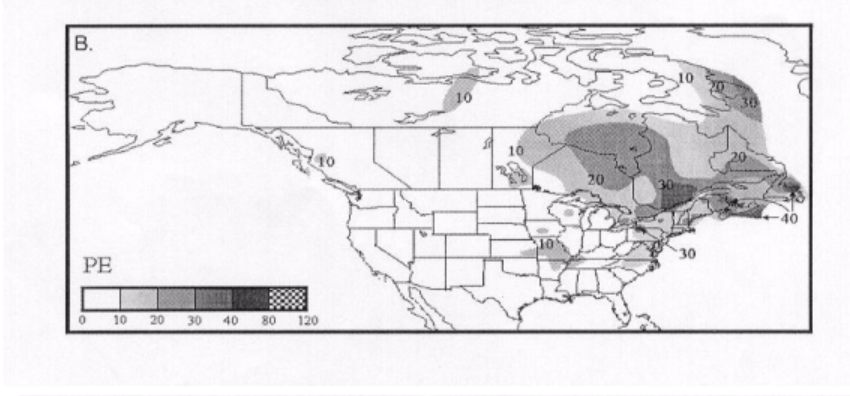
Ice pellets are most common in the wintery and shoulder season months, when temperatures are sufficiently cold. They are a more common occurrence in Eastern and Atlantic Canada due to the maritime weather systems they often experience, and although less common they also occur over the Prairie Provinces and British Columbia. Northern Canada can experience ice pellets as well in the shoulder seasons, however during the winter months it is generally too cold and precipitation, for the most part, falls as snow.
It is important to note that on a year-to-year basis, the occurrence of ice pellets varies by region based on local weather conditions.
This image is adapted from Cortinas Jr. et al. (2000). Displayed in the image is the expected number of hours of ice pellets annually.
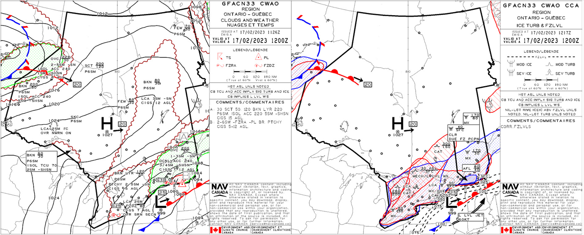
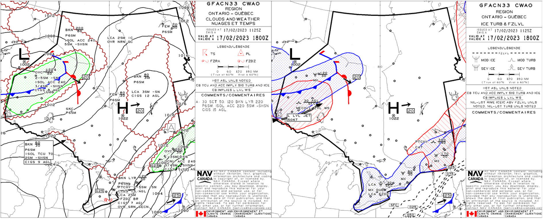
The GFA panels valid at 1200Z on February 17, 2023 show a low pressure system centered over New York State and its associated frontal boundaries. Ice pellets and associated severe clear icing are forecast for the Montreal region and extreme southern Quebec ahead of the warm front. These conditions are made possible by sub-zero temperatures at the lowest levels of the atmosphere and a layer of warmer air aloft. Surface sub-zero temperatures stem from gusty northeasterly winds north of the low, while warm air advection over the warm front is enhanced by a 60KT low-level jet. This setup strengthens the low-level inversion and results in the above-freezing level between 4000-8000ft seen in the icing and turbulence panel.
Only 6-hours later, the 1800Z panel shows how rapidly conditions are expected to change over southern Quebec with the passage of the low. Though northeasterly winds remain at the surface, upper-level support for ice pellet formation – the low-level jet and associated warm air advection – are expected to have moved away from the station. This spells the end of any ice pellet risk as the inversion that had supported the freezing precipitation has moved out of the region.
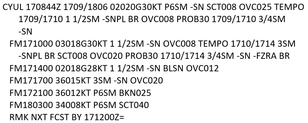
The TAF for CYUL, showing forecast conditions between February 17th at 0900Z through Feb 18th at 0600Z, shows the gradual expected transition from mixed freezing precipitation and snow, to snow alone, and finally clearing, as shown in the GFA panels. Initially, strong winds and freezing precipitation are forecast. Winds are expected to remain northeasterly throughout the event, until they back to the north on the backside of the low under improving conditions. Freezing precipitation is forecast to transition to only snow after 1400Z, signaling the exit of the inversion as the warm front continues its path eastward, taking the warm air advection aloft with it.
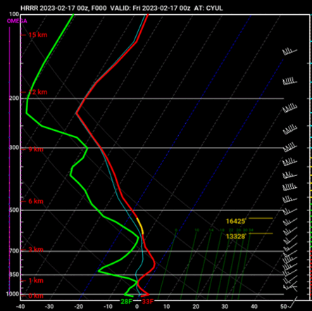
Model atmospheric profiles provide insight to the ingredients likely present to support freezing precipitation, and in this case, ice pellets. As discussed in the science explained section, the sub-freezing layer at the surface needs to be deep enough to allow for raindrops to refreeze before reaching the surface, while an AFL exists aloft. These RDPS model profiles forecasting conditions from 0000Z through 1500Z on February 17th capture both the onset of ice pellets and their departure. The warm layer and top of the inversion are forecast to start developing around 0600Z in southerly winds at 850mb. The low-level jet is also represented in the 0900Z and 1200Z profiles; 55KT around 800mb, helping enhance the warm nose. At the surface and in the lowest levels of the atmosphere, northeasterly winds are expected throughout the event, which helps maintain sub-zero temperatures as they pull in cold air from ahead of the low. The cessation, as shown in the GFAs, TAF, and strategic charts, comes as the warm front moves away from CYUL taking with it the warm air aloft needed to melt snowflakes into raindrops. In the profiles, this is seen at 1500Z, as winds aloft shift to a westerly direction, and the warm nose is forecast to move off. With temperatures through the column below zero, forecasters would anticipate ice pellets to transition to snow, which is what is shown in the TAF.
Image Source: Pivotal Weather
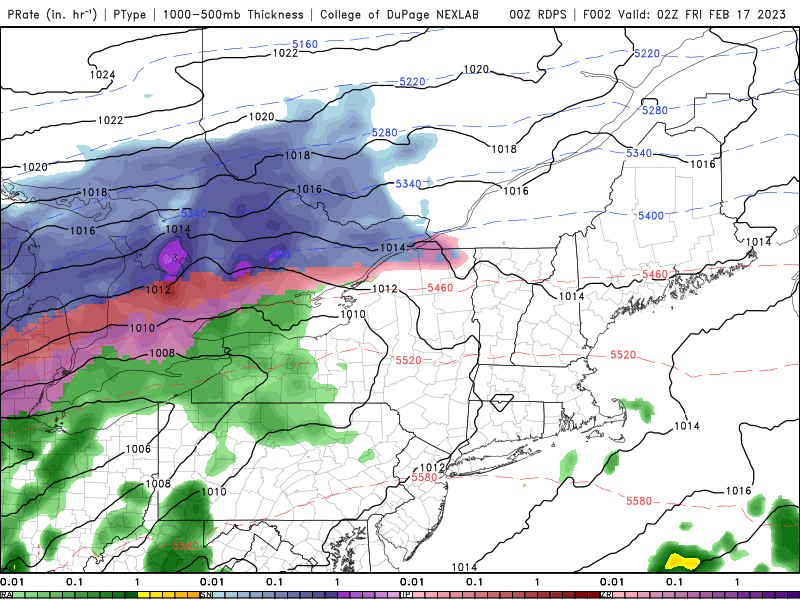
This RDPS graphical forecast model product for precipitation type and rate is shown here predicting conditions between 0200Z and 1700Z on February 17th. Forecast model data supports the GFAs, TAF, and atmospheric profiles in the progression of the low across the region and over CYUL in particular. This model predicts that ice pellets (or freezing precipitation) are expected from 0600-1400Z on Feb 17th as CYUL is located in the red/purple region, with a transition to snow forecast as the low’s warm front moves into Maine.
Image Source: College of DuPage
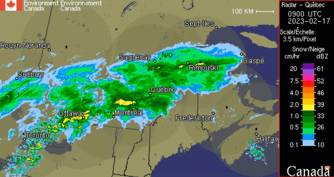
Radar data captured on February 17th from 0900Z-1400Z shows precipitation associated with the low-pressure system covering portions of southern Ontario, southern Quebec and the northeastern United States. Though this specific radar imagery cannot differentiate between precipitation types, forecasters may look for evidence that is beyond the scope of this website.
Image Source: Environment and Climate Change Canada
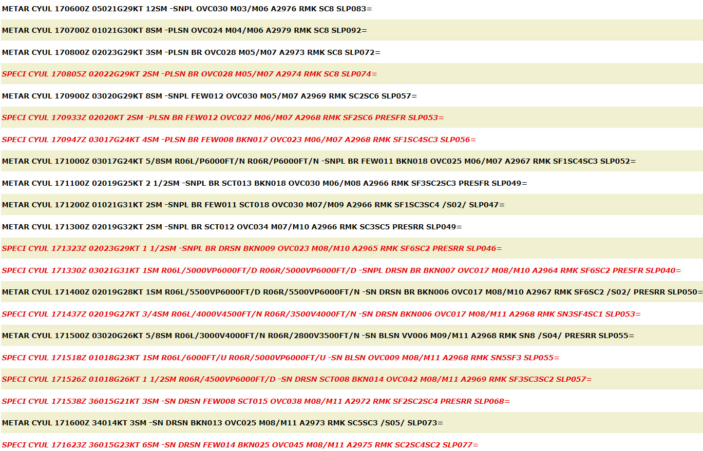
METARs captured between 0600Z and 1623Z on February 17th show ice pellets on-going by 0600Z and a transition to snow at 1400Z, as initially forecast by the TAF. Winds remain northeasterly as predicted in both the GFAs and the TAF until the low moves far enough eastward to shift the synoptic flow more northerly over the CYUL area.
Image Source: OGIMET
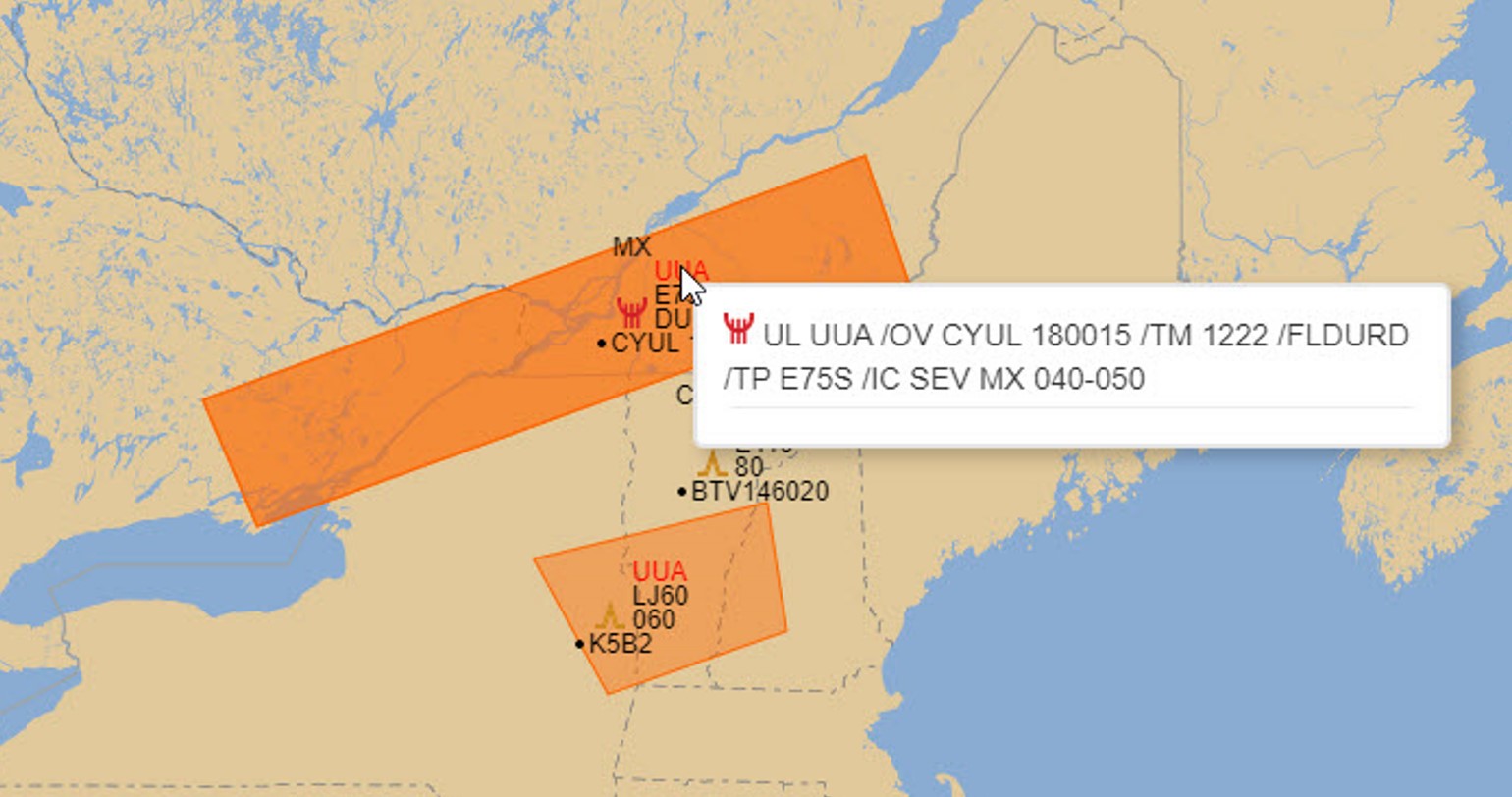
At 1222Z a severe icing PIREP was received, between FL040-050, which per the GFA would be directly within the zone described below the AFL. All received PIREPs are assessed and considered by forecasters when issuing or modifying SIGMETs.
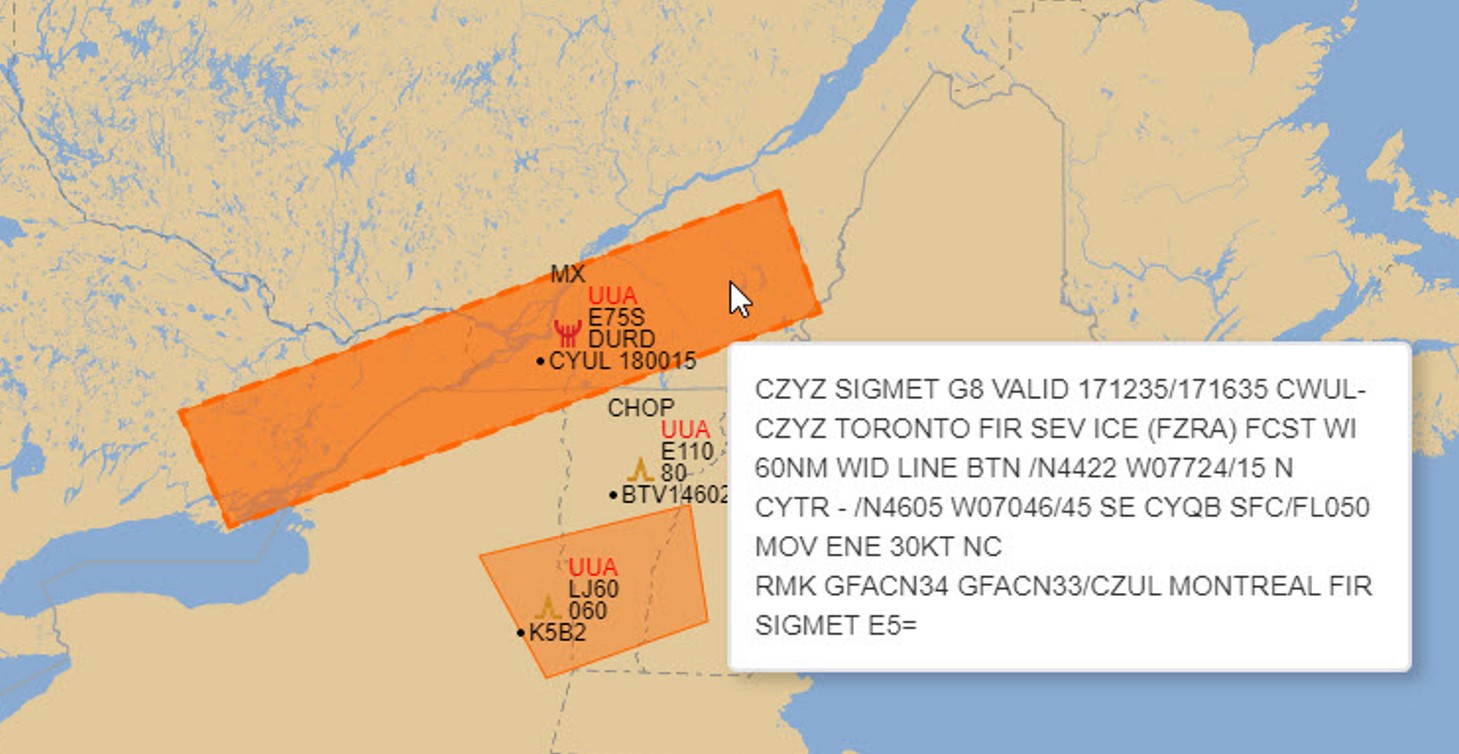
The SIGMET issued and valid 1235-1635Z captures the severe icing expected within the area, from the surface up to FL060. This is the area of sub-zero temperatures below the AFL described by the GFA icing and turbulence panel at 1200Z and seen in RDPS model profiles. The SIGMET’s movement is east-northeast at 30KT, following the trajectory of the low and its associated warm front that is supporting ice pellet formation.
Where supercooled water droplets exist in-flight there is a risk of ice accretion and loss of lift. Reduced braking action and higher runway occupancy time on the ground.
The concern for ice pellets depends on other conditions such as ambient and surface temperatures. Depending on these temperatures, ice pellets could be easily swept off pavement and sprayed off aircraft or it could result in ice pellets melting and creating clear ice hazards.
Depending on the conditions, ice pellets when not adhering to surfaces can be handled as snow, but will otherwise be treated similar to freezing rain.
Operations Duty Managers
In CYUL ice pellet events occur more frequently than they do at the other major airports and have similarities to snow and freezing rain events:
In CYYZ: ice pellet events are rare and the effects are similar to snow.
In Edmonton, AB (CYEG): ice pellet events rarely impact operations.
In Winnipeg, MB (CYWG):
Generally, ice pellets will be handled very similarly if not the same as snow.
From there a collaborative decision-making conference call will occur the same as in a snowstorm.
ATC (Major Tower)
Same impact as for freezing rain.
Observed ice pellets are one method of detecting heightened risk of inflight Icing, as the formation of this precipitation type demands the presence of an above-freezing layer aloft, with a layer of freezing air beneath it. Thus, the report of ice pellets infers a complex and evolving temperature/moisture regime aloft, which low-time pilots and those flying aircraft without anti-icing equipment would be prudent to avoid. Some aircraft can rapidly ascend or descend through the threat, while other aircraft types simply cannot compensate for the adverse environmental conditions due to design limitations. Pilots must decide if the risk is acceptable for their airframe type ie. the crew of a Boeing 737-800 equipped with “Hot Wings” would be largely indifferent to Ice Pellets and associated hazards, but for a student pilot in a Cessna 150 doing circuits, this would be a potential showstopper. Ice pellets are an indicator that freezing rain is nearby, and specialists will often contact the Airport Maintenance Personnel to warn them of the potential.
Advisory specialists will always increase our checks of the Ice Accretion Indicator as ice pellets are a sign of potential freezing rain in the vicinity. We will always advise the Airport Maintainers of that ice pellets have started so they can begin ice mitigation procedures.
Ice pellets are looked at in the same way as freezing rain for IFR en-route controllers. It is a situation to be monitored, but from our point of view, we are more reactionary than anticipatory.
When ice pellets start to fall and accumulate on the ground, en-route controllers begin to prepare for an increased workload.
Should any airport be unable to treat their runways and subsequently close them until conditions improve, ATC is required to inform any pilots flying to that destination once a NOTAM is published. This is more frequent with smaller airports which do not have proper equipment. The impact of this is increased ATC workload.
If airports begin to close, aircraft are given holding patterns and, depending on the duration of the event, often rerouted to alternate destinations.
Major airports are far clearer in communicating/broadcasting when RWYs are unavailable or when there is reduced capacity – it’s communicated on the ATIS (automatic terminal information service), on Collaborative Decision-Making/National Operations Centre calls, and controllers are made aware easily with tools they have at their positions. There are no NOTAMs, just a clear indication of expectation for runway closure duration, anticipated return, and currently active runway (if available).
For smaller regional/municipal/personal airports, there is no ATIS and information may not be communicated as efficiently.
Ice pellets are associated with a number of significant constraints to airline operations:
De-icing and slippery conditions tend to reduce airport throughput and introduce delays that can lead to cancellations that can become significant during prolonged periods of ice pellets. Costs to airlines can be significant with increased use of deice fluids and fuel carriage along with all the associated costs that come with cancellations.
As ice pellets can degrade airport surface areas, wind direction and speed play important roles when it comes to crosswind limitations for takeoff, landing and general maneuvering. Slippery runways can contribute to reduced take off weights.
With an ice pellets event, our mitigation steps will be similar to winter operations: takeoff performance assessment, de-icing operations, slippery conditions on taxiway and engine runup.
Firstly, for the takeoff performance assessment, the probable contaminants can vary with ice pellets: snow, slush, and ice.
For de-icing and anti-icing operations, ice pellet precipitation is in a category of its own. Holdover times are developed using testing protocols, and these protocols rely predominantly on the visual inspection of test surfaces to determine fluid failure, which occurs when the fluid is no longer able to absorb actively occurring frozen or freezing precipitation (Transports Canada – TP 14052).
Ice pellets do not create the same risk of icing as freeing rain or drizzle because they do not instantly adhere to the airframe. However, it is recommended that General Aviation Visual Flight Rules (GA VFR) pilots not fly in these forecast/occurring conditions because of the potential for even worse conditions in flight (freezing rain) as well as a reduction in visibility, similar to that with snow.
If there is recent precipitation in the form of ice pellets it is unlikely that a flight will occur. However, certain precautions must be taken if the aircraft is going to be maneuvered on the ground.
If encountered in flight, it may be hard to differentiate from snow, especially if flying into it from an area that already had snow falling.
As a rule of thumb, GA VFR pilots do not usually fly in the vicinity of a winter warm front.