METAR Code
FZRA
Weather Symbol

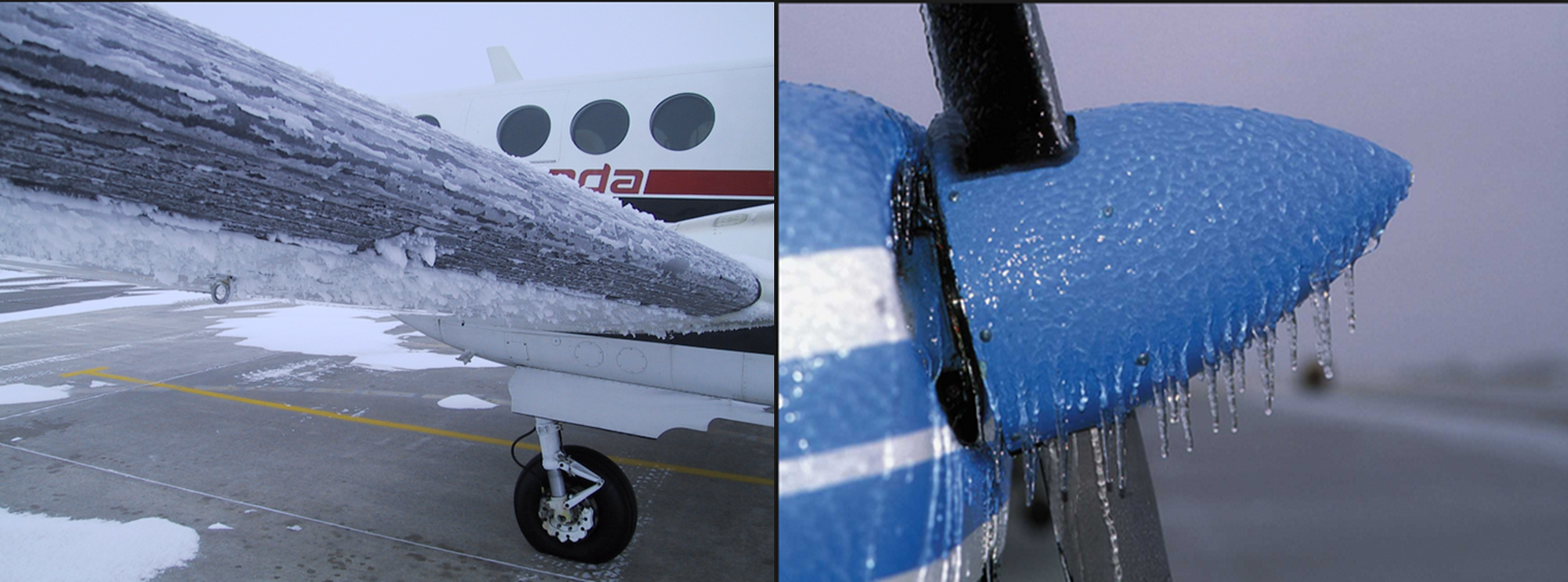
Example of in-flight icing caused by freezing rain.
Rain that falls in liquid form but freezes upon contact with the ground or other surfaces. It occurs when a near or above freezing level exists in the atmosphere allowing ice at altitude to melt to rain and then freeze on contact with the surface. These near and above freezing layers generally exist within the vicinity of warm fronts and trowals, though freezing rain can also occur locally in valleys where cold air is channeled.
Associated terms coming soon:
Cold air damming, inversion, low-pressure system, and wind channeling are all terms associated with freezing rain that will be coming soon to the Aviation Meteorology Reference.
When freezing rain occurs, the following conditions are usually satisfied:
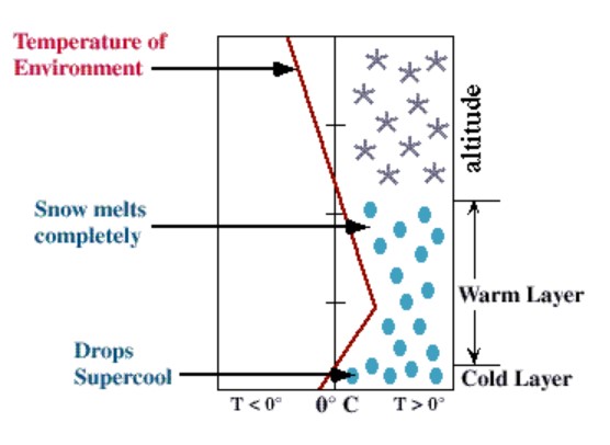
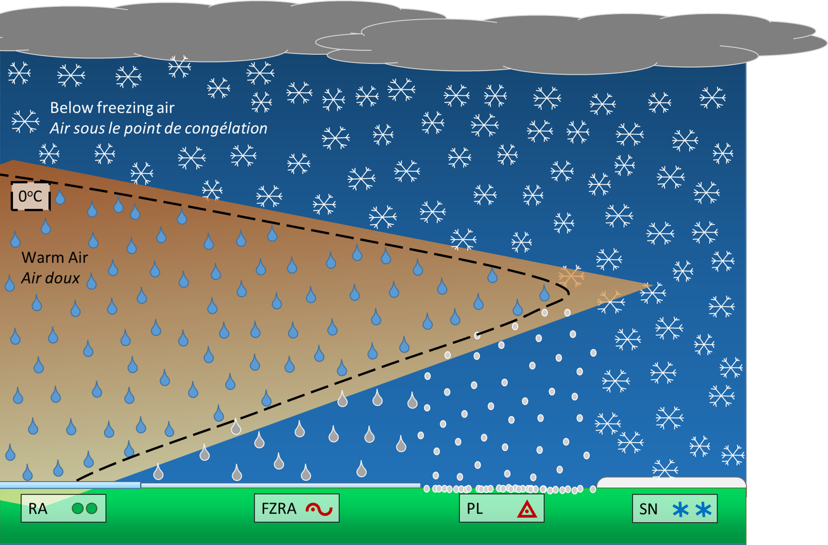
The figure on the left visually depicts a typical atmospheric profile that fits this description. When precipitation develops, it starts in the form of snow or ice crystals. In usual wintry conditions, this snow reaches the surface intact. In cases of freezing rain (FZRA), it encounters a layer of warm air that is near or above 0°C. If this layer is sufficiently thick, the snow will melt completely into rain. If this rain then encounters a surface layer of colder air, with temperatures below 0°C, the rain droplets temperature will dip below freezing. If this cold layer is thick, the rain droplets will have time to re-freeze and form ice pellets (PL). However, if the layer of cold air is shallow, the droplets will not have time to re-freeze, and will freeze on contact with the ground or other surfaces below 0°C.
Image source: Environment and Climate Change Canada
Duration
Dissipation
Image source: Environment and Climate Change Canada
Freezing rain poses a forecasting challenge in diagnosing the relative thicknesses of the warm, melting layer, and the cold, re-freezing layer. If the warm layer is thick, and the cold layer shallow, freezing rain is almost guaranteed. However, if both layers are thick, freezing rain, ice pellets, or a combination of the two, are possible. In cases of a shallow warm layer, only partial melting of the snow would lead to ice pellets possibly mixed with unmelted snow. This challenge in diagnosing the relative thickness of the above-and-below freezing layers is why you often see TAFs whose main or TEMPO condition is PL, with FZRA in a PROB. In this scenario, the forecaster has assessed that the relative depths of the layers are more conducive to ice pellets, but if the warm layer is slightly thicker, or the cold layer shallower, precipitation might fall as FZRA. Tools such as model soundings, radiosondes, and radar imagery can help forecasters determine the relative depths of these two essential layers.
Freezing rain is generally well predicted by numerical models, except in areas where local effects cause models to inaccurately predict surface temperatures. The most notable exception is in valleys, where cold air remains trapped in the valley even after the warm front has passed. In this case, forecasters will use their knowledge of local effects and climatological data to predict the end of a freezing rain event.
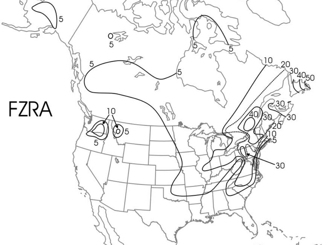
Two valleys in Canada that are especially prone to freezing rain events are the Ottawa Valley and the Saint-Lawrence Valley (see image on the left, showing median annual precipitation days for freezing rain (1976-1990)). The infamous 1998 freezing rain event affected both these valleys and much of eastern Ontario and Southern Quebec for 5 days and brought up to 100 mm of freezing rain to some areas. These long lasting events are very rare with most freezing rain events lasting only a few hours. Freezing rain is also common in Atlantic Canada, who suffer the brunt of the winter storm track. The interior valleys of British Columbia can also have events of freezing rain, however these tend to be shorter lived.
Image source: Cortinas Jr. et al. (2004).
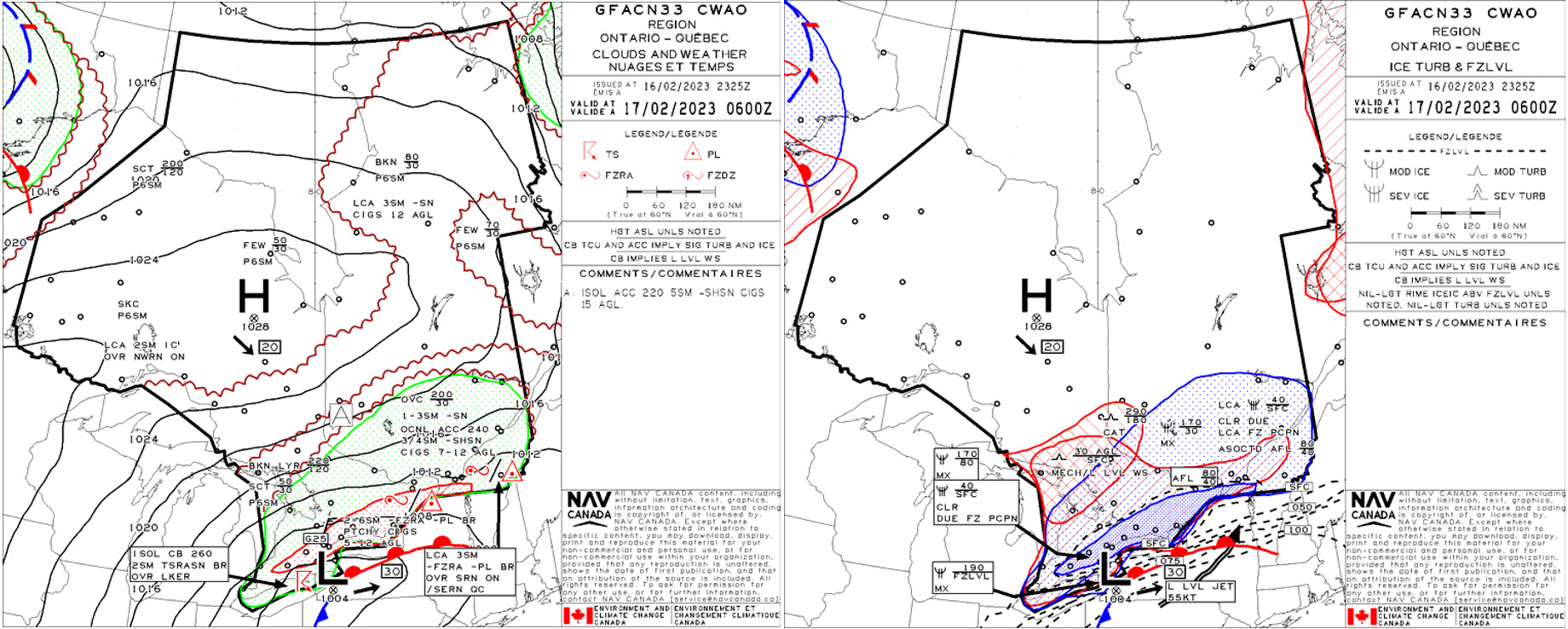
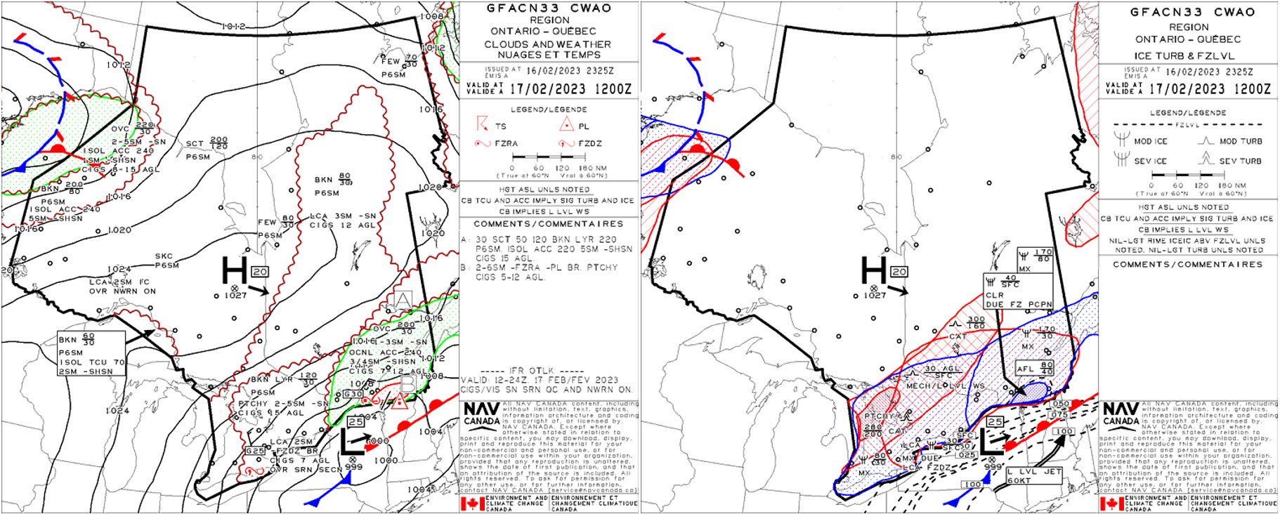
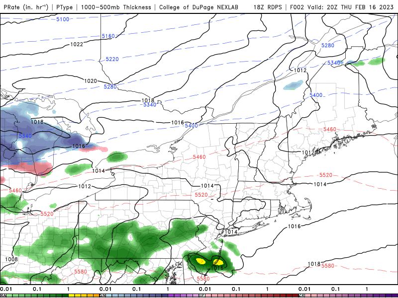
The clouds and weather GFA panel issued at 2325Z on February 16, 2023 and valid at 0600Z February 17 shows an area of continuous freezing precipitation across most of southern Ontario, from London (CYXU) to just south of Montreal (CYUL). The associated icing and turbulence panel valid at the same timestep shows a continuous area of severe clear icing between the surface and 4000 feet, due to the above-freezing layer between 4000-8000 feet. As shown in the science explained tab, this AFL melts frozen precipitation, which then either refreezes as it falls through the sub-zero layer below (giving ice pellets) or freezes on contact with the surface (giving freezing rain). This zone of freezing precipitation is supported by a well-developed low-pressure system and enhanced by the presence of a 55KT low-level jet. This jet enhances the warm air advection over the region at low levels, helping support the AFL that in turn sets the stage for freezing rain formation.
By 1200Z on February 17th, the low-pressure system has continued its ENE trajectory and is forecast to be centered over eastern New York state, spelling the end of freezing rain for Toronto (CYYZ) sometime between 0600Z and 1200Z (specific timings are always shown in the TAF). The freezing precipitation occurring ahead of the warm front and its associated area of severe clear icing has dissipated across southern Ontario as it is directly tied to these features and therefore would not form elsewhere where conditions do not support it.
The TAF issued at 1740Z for February 16th indicates the potential for freezing precipitation starting at 2300Z until 0000Z as a PROB30 of ice pellets. Between 0000Z and 0200Z, light rain mixed intermittently with ice pellets is forecast, along with a PROB30 for freezing rain. This gradual transition is a result of the way warm air aloft building in while cold air at the surface gradually drops temperatures below the zero-degree mark in northeasterly winds. The transition between ice pellets and freezing rain occurs as the sub-zero layer gradually becomes thinner as the AFL increases in depth (see atmospheric profiles for more info). By 0200Z until 0600Z, the main condition is forecast to be freezing rain as the area of continuous precipitation and associated vertical structure shown in the GFA and sounding profiles moves over CYYZ and temperatures are expected to be below zero. The dissipation of freezing rain is also shown in the TAF as a transition to pellets mixed with snow and finally straight light snow as the low continues its trajectory eastward. The warm air advection ahead of the low is then no longer over CYYZ. With that warm air advection (WAA) no longer over CYYZ, one of the primary conditions required for freezing rain is no longer present, hence the changeover back to frozen precipitation.
A later TAF was amended at 2305Z to reflect freezing rain verifying in surface observations and validating freezing precipitation in the area. These observations indicate that the sub-zero layer initially forecast by the models was thinner than expected, with a transition straight to -FZRA rather than ice pellets first.
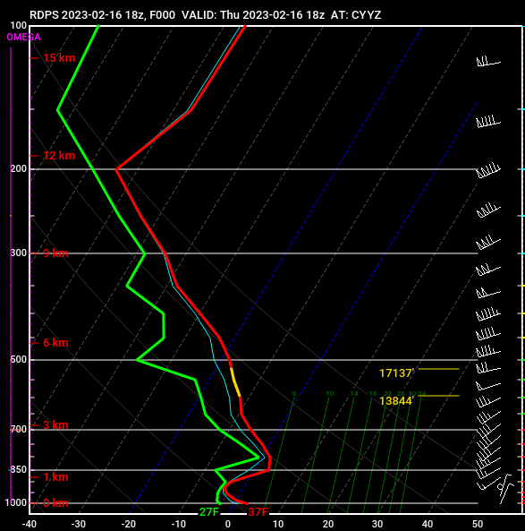
Model soundings from the Canadian Regional Deterministic Prediction System model, initialized at 1800Z on February 16th and valid between 16/1800Z and 17/1200Z beautifully depict the development and dissipation of freezing rain over CYYZ. Before the start of the event (1800-2305Z), when both the TAF and the GFAs show light rain over CYYZ, soundings indicate surface temperatures gradually dropping. Between the 2100Z sounding and the 0000Z, these temperatures go from 36F (2C) to 31F (-0.5C). The northeasterly winds seen at lowest levels are what is driving this colder air moving in and dropping temperatures. Aloft, winds veer to the south, and then southwest. This “veering” is a classic signature of warm-air advection, which supports the strengthening of the AFL shown in the GFA. These features, coupled together with the presence of clouds through 20,000 feet sets the stage for continuous freezing rain. By 0000Z, the AFL can be distinctly seen in the sounding, between approximately 4000-8000 feet. Through these altitudes, the temperature of the environment is forecast to be above zero (the 0 degree isotherm is diagonally sloped from left to right from the x-axis). These ideal conditions to maintain freezing rain are forecast in soundings to remain in place until 0600Z. Between 0600Z and 0900Z soundings start to pick up on a gradual dissipation of the AFL, with temperatures aloft beginning to cool. This is due to the low’s movement eastward, taking with it the low-level jet that supports WAA aloft. This is captured in the change in wind patterns at 0900Z and beyond, with surface winds backing to the north and low-level winds becoming more westerly. This shift spells the end of the WAA and in turn results in the dissipation of the warm nose aloft, causing the phase change forecast at the surface from freezing rain to ice pellets and finally to snow.
Image Source: Pivotal Weather
Canadian Regional Deterministic Prediction System model data initialized at 1800Z and valid between 16/2000Z and 17/1100Z shows the low’s forecast movement and the associated precipitation types across the region. At the start of the event, CYYZ is on the boundary between rain and freezing rain, but transitions into the continuous freezing rain area as the low continues to move east northeastward. The transition back to snow in CYYZ as described in the GFA, TAF, and soundings, can also be seen in this forecast as the airport gradually finds itself on the backside of the low. Precipitation types support other products in showing this transition, with freezing rain located only where conditions favour its development.
Image source: College of DuPage
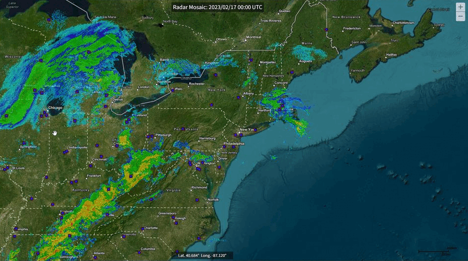
This radar loop from 17/0000Z to 17/1200Z shows areas of precipitation across southern Ontario associated with the low-pressure system’s passage. This precipitation, as shown in the GFA panels, is connected to the low’s warm front, and can be seen transiting through the region and eastward following the low’s progression. Freezing rain, as shown in the METARs, was observed at CYYZ for 10 hours, between 16/2300Z and 17/0900Z. How to tell when the precipitation begins to change over? By tracking the low’s center and the cold front. At 17/0400Z, the cold front becomes more developed, shown as a thin line of precipitation cutting N-S through central Ohio. By 0630Z, both the warm and cold fronts are well-defined, and the backside of the low can be seen by the lack of precipitation across southwestern Ontario, west of CYYZ. This trajectory, as shown in the GFA, TAF, soundings, and model tabs, both cuts off the WAA aloft and results in lower cloud tops over the CYYZ area. The loss of these crucial ingredients means no more freezing rain.
Image source: NCEI/NOAAOpen a new window
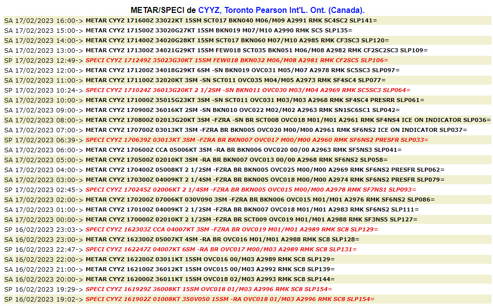
Freezing rain was observed for 10 hours at CYYZ between 16/2300Z and 17/0900Z, as shown by the -FZRA in METARs for that day. -RA was, however, observed for 1.5 hours between 0500-0639Z as temperatures hovered close to zero through the event. Transition at the start of the event went from light rain to freezing rain, due to the cold air advection in north to northeasterly winds helping drop temperatures to at or just below zero. These winds remained northeasterly, and temperatures continued to hover there until the low’s center moved east of CYYZ. This trajectory, as shown in GFA panels, in forecast model graphics, and in satellite and radar imagery triggers a gradual wind shift from northeast to northerly, starting around 0639Z. After this shift starts, temperatures continue to drop about 1C/hour. However, though this may normally help sustain freezing rain, a transition to snow occurs as the low’s movement also leads to dissipation of the AFL above CYYZ.
Image source: OGIMET
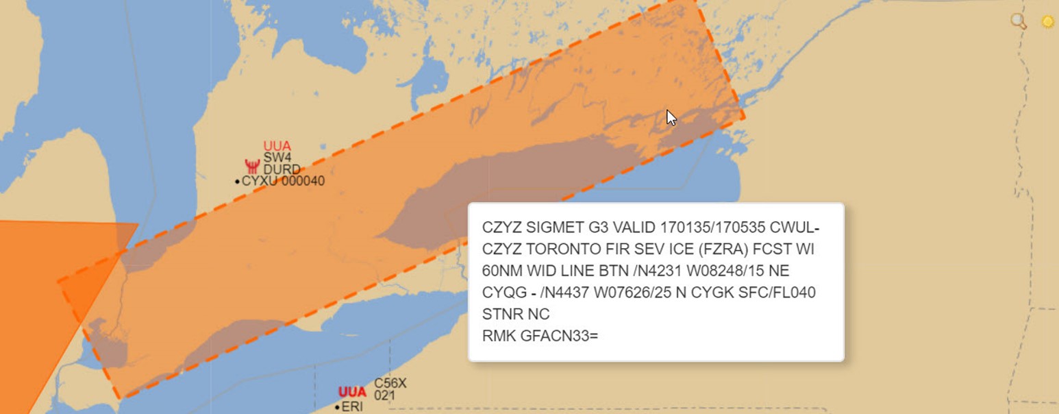
This forecast SIGMET was issued at 0135Z on February 17, 2023 with multiple reports of freezing rain observed across much of southern Ontario. This includes London (CYXU), Kitchener (CYKF), Toronto (CYYZ), Billy Bishop (CYTZ), Peterborough (CYPQ), Trenton (CYTR), and Kingston (CYGK). No PIREPs were received indicating severe icing, which is the reason why this SIGMET was issued as forecast and not observed.
Tends to be more severe than freezing drizzle but same general impacts. Loss of lift due to ice accretion on critical surfaces, higher runway occupancy time, reduced braking action capability and potentially slippery surfaces due to accumulation on the ground.
Freezing rain events tend to be an unusual weather event at West Coast airports (like CYVR), but are more common at CYYZ and CYUL.
Outside of the impact to aircraft/aviation, ice accretion will also have significant impact to the airport in other ways:
Other impacts:
Operations Duty Managers
A good knowledge of expected icing is important. The TAF is carefully reviewed to determine intensity, time frame, accumulation anticipated, forecaster confidence level.
Information is gathered on what the Airport Authority plan is for treating runways that are active and ones that may be activated to keep operations flexible, time frames and arrival spikes to prepare for, staff limitations, D-TMI details.
Operations Duty Managers will take all information provided in a forecast, from Airport Authorities, from the NTMU, and from the Airlines to discuss the operational plan in-depth with their tower, terminal, and en-route ATC supervisors.
Some additional considerations taken by an Operations Duty Manager planning during a freezing rain event:
Operators generally have a good knowledge of expected icing conditions and are prepared and flight planned to avoid the worst areas of icing- ATC intervention is often not required.
Freezing rain is considered to be a rare event in the Canadian Prairies (ZEG FIR).
Usually freezing rain is not isolated and happens over large areas, affecting more than one major airport in Canada or the FAA, this can lead to multiple delays as airlines get off schedule and struggle to keep the system updated meaning volume information is not very accurate.
ATC (Major Tower)
The TAF, public forecasts, watches, and warnings are all reviewed when planning and preparing for an event.
ADM personnel monitor the arrival of the freezing rain to accurately time runway treatment prior to onset. So much so that when they ask to extend the product, it has to be done right away, otherwise it won't work.
Additional ATC staff will be called in as workload during freezing rain events can be complex.
Extensive communications are required throughout a freezing rain event with the Airport Authority, Terminal ATC, and NAV CANADA’s Operations Duty Manager, and NTMU.
During a severe precipitation episode, the delays at the deicing center are extremely long.
ATC (Regional Tower)
Airport authority will be working hard to ensure the runway friction index is suitable for the airlines. Regional tower ATC facilitates passing on that information in a timely manner.
Freezing rain is definitely a greater threat to aviation safety than snow, as it adheres to all surfaces on an aircraft in flight, adding weight while degrading aerodynamic performance. Additionally, it is significantly more difficult to operate on an ice-covered manoeuvring area than one that only has snow on it, while ice clearing operations are slow and expensive due to more chemicals being needed to melt the ice. The best way for Airport Maintenance Personnel to deal with freezing rain events is to get ahead of the game and get chemicals down to stop the ice from sticking in the first place. As freezing rain may follow a period of rain, timing the chemical application so it’s not washed away before the freezing rain starts is crucial.
FSS, whether operating at an airport or in a FIC, pay very close attention to any potential freezing rain event, due to the threat to safety and the resulting degradation of operational efficiency – longer Runway Occupancy Times, reduced speed on taxiways and aprons, and impaired efficiency of ramp operations translate directly to delays for all airport customers.
FIC
Right at the start of any Pilot Briefing, any serious threat to safety will be mentioned first – as this information may cause the pilot to delay or cancel the flight due to an unacceptable level of risk, and they may even pause the briefing to advise Dispatch or the Customer directly. Freezing rain is definitely in that category of threat.
The Briefing Specialist will communicate observed and/or forecast freezing rain as it relates to the pilot’s flight plan including start times, end times, and extent of spatial coverage and emphasize the level of risk inherent in conducting Flight Operations under such hazardous conditions. A critical aspect of a specialist’s role is to communicate such hazardous conditions, with weather briefings meant to strengthen a pilot’s situational awareness and decision-making by providing context, local knowledge, and the latest weather information. Safety remains at the core of every briefing we provide.
AAS
Advisory specialists monitor possible freezing rain conditions primarily with the ice accretion indicator, but also monitoring precipitation rates and temperature. We must account for de-icing and holdover times when working with IFR controllers for arrival/departure sequencing and keeping maintenance vehicles on the manoeuvring area for as long as possible before a departure or arrival.
Freezing rain affects terminal ATC similar to snow, but far worse, especially on the arrivals side.
Icing on final approach
When pilots get severe icing, they want to stay in it for as little time as possible.
Freezing rain will only impact high level ATC indirectly.
The TAF is not used by high-level ATC for planning local flights heading to regional airports.
In high-level sectors such as the North High in Montreal's FIR, the impact of freezing rain for the high level involves a few more steps in the analysis of ATC tasks.
Freezing rain events are some of the most challenging weather conditions an airline will operate in and a heightened level of safety consciousness is required:
Weather products used:
Freezing Rain has a significant impact on flight operations. The impact on pilots is similar at regional airports to major airports. For major airports:
Freezing rain is associated with severe icing conditions. Aircraft are not certified for flight in severe icing and severe icing conditions can overwhelm the aircraft de-icing and anti-icing systems. Ice can form on the aircraft increasing the aircraft weight and modifying the shape of the aircraft’s aerodynamics. Ice can build on the aircraft propellers and jet engine fan blades leading to severe vibration. Pilots will not knowingly enter severe icing conditions and if severe icing is encountered, procedure is to exit the conditions as quickly as possible.
Ground Operations
If freezing rain is present or predicted on any weather products, GA (General Aviation) Visual Flight Rules flights will not occur. Some small and medium GA aircraft are equipped for anti-icing, but these systems are commonly not approved for flight into known icing conditions. They typically exist as a back up if unpredicted icing occurs in flight.
For GA VFR pilots, if icing is encountered in freezing rain, their best bet is to climb out of it and into warmer temperatures. However, should the accumulation on the critical surfaces make it difficult to achieve the performance necessary to climb, the next best option is to immediately reverse course to return to non-icing conditions. Once out of icing conditions it would be advisable to descend to warmer temperatures, if possible, to attempt to melt any accumulated ice. The critical notion here for a GA pilot is their need to be spatially aware of where they are in reference to the occurring freezing rain and associated weather systems. This is because there is a chance, with the temperature inversion in the area, that temperatures may actually be colder below them! It is in cases like this where proper flight planning and analysis of weather maps can make a difference in the safe execution of a GA flight.
For GA pilots operating IFR, there are some systems approved for flight in known icing conditions, especially in multi-engine or turbine powered GA aircraft, but it is not always recommended to plan a flight into known icing because the capability of these systems will vary depending on the severity of the icing.
Anything beyond light icing can surpass the limits of smaller aircraft anti-icing systems, so pilots should use extreme caution if they choose to operate in these conditions, keeping in mind that a known presence of icing can quickly change severity.