METAR Code
N/A
Weather Symbol
SIGMETs describe hazards observed or predicted, as well as their evolution over time. They are emitted to describe hazards that are occurring related to:
Information message issued by a meteorological watch office (MWO) to advise pilots of the occurrence or expected occurrence of specified weather phenomena, which may affect the safety of aircraft operations, and the development of those phenomena in time and space.
A SIGMET is an internationally used and recognized product as designed by the World Meteorological Organization (WMO), the format of which is defined in detail in Chapter 5 of MANAIR Eighth editionOpen a new window. It serves to warn aviators of meteorological conditions spread over an area (i.e., not a local effect) considered “severe” in nature and are likely to have pronounced negative consequences on aircraft that encounter those conditions.
In Canada, the SIGMETs dealing with weather phenomena are the most common (with the exception of dust and sandstorms).
The forecaster will begin drafting a SIGMET when certain criteria reach or are suspected to have been reached in a region, allowing the weather to reach "severe" status. For weather phenomena, the criteria are as shown in the table on the left.
Any SIGMETs can be reissued anytime and is usually done if the zone drawn no longer well represents the weather, or if the details of the phenomena have changed, or are expected to change.
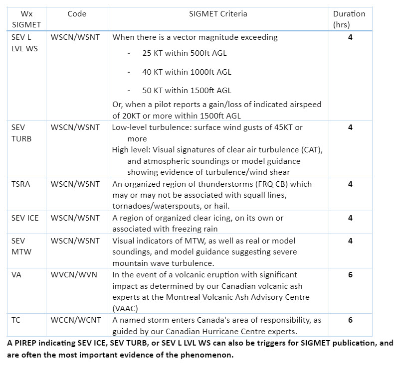
A “forecast” (FCST) SIGMET is reserved for times when the phenomenon cannot be directly or indirectly observed, but the forecaster strongly suspects that the event is occurring.
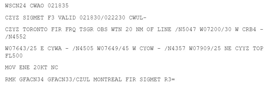
The image shown here is an example of a forecast SIGMET for severe mechanical turbulence, issued on March 25, 2023 over southeastern, including St. John's airport (CYYT).
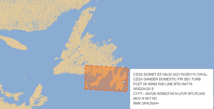
A SIGMET can be transmitted as “observed” (OBS) as long as there is a recent direct (eg. METAR, PIREP, atmospheric sounding) or indirect (eg. radar, webcam) observation of the event, leading the forecaster to believe the phenomenon is present.
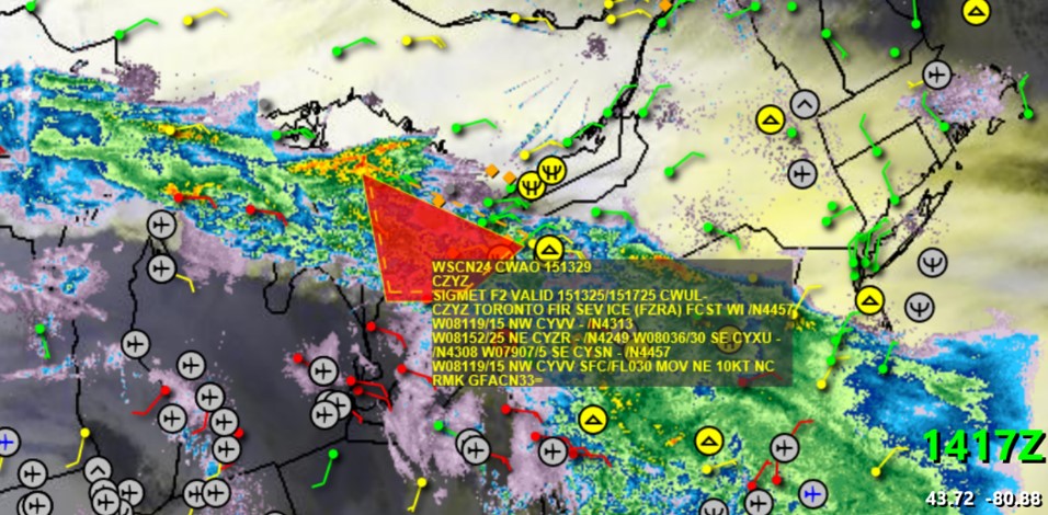
This image is an example of a PIREP received for moderate to severe turbulence, followed by the issuance of an observed SIGMET over the region determined by the forecaster to be most likely to see similar conditions.
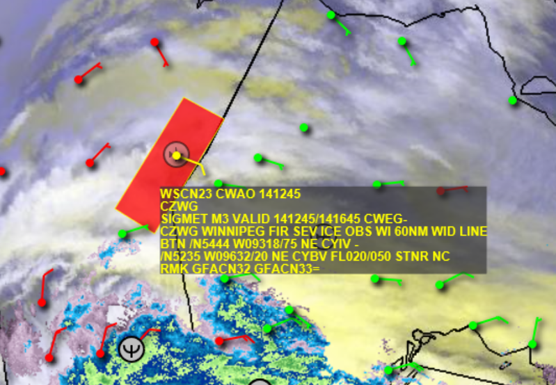
SIGMETs are retired when the phenomenon is expected or observed to no longer meet SEVERE criteria (PIREP indicating lower severity, METARs no longer reporting phenomenon, satellite signature dissipates, etc).
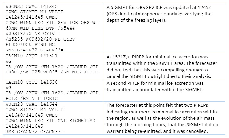
For example, in the image on the left, two PIREPs for NIL ICE (icing) were transmitted within a SIGMET for SEV ICE, which was enough for the forecaster to retire the warning early, as they have no other compelling evidence to keep it.
This SIGMET is used as an example, with the order of events shown in the next image.
Image Source: Environment and Climate Change Canada
While lines of thunderstorms or regions of widespread wind gusts exceeding 45KT are easy to identify and create SIGMETs for, there can be complicating factors when drawing SIGMETs.
Canada is relatively data sparse compared to other regions, so forecasters often do not have PIREPs to assist their analysis. PIREPs of NIL ICE within a SIGMET for SEV ICE (for example, as shown in the first image within the dissipation tab) are just as useful as a PIREP indicating SEV TURB, as it can trigger the removal or update of a SIGMET.
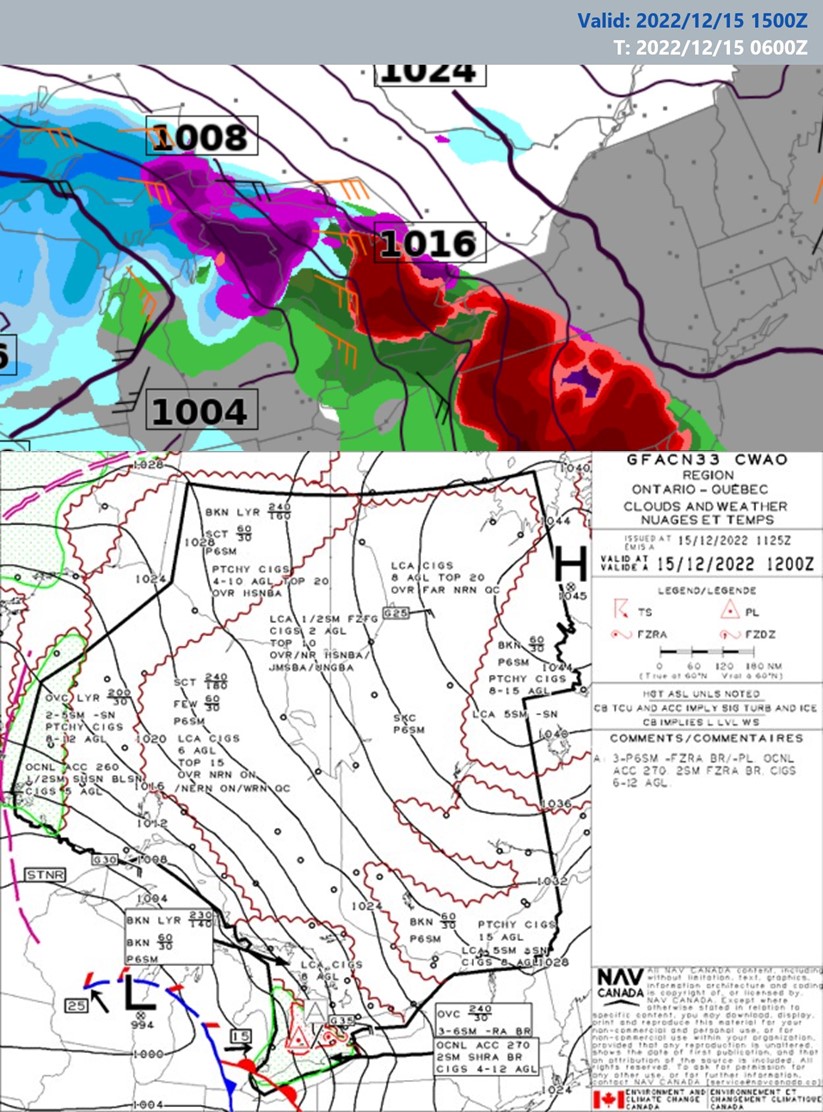
Another example, in the RDPS model output shown here there is a vast region of freezing rain and ice pellets expected to impact southern Ontario. No PIREPs were issued to confirm SEV ICE at altitude, but in this case, the forecaster had at least a few METARs of FZRA on the ground (yet as discussed, this does not count as a direct observation of icing above ground).
The GFA valid at 1200Z is shown here, depicting freezing precipitation (freezing rain, pellets) ahead of the impending warm front over southern Ontario corresponding with model data above.
Image Source: Environment and Climate Change Canada
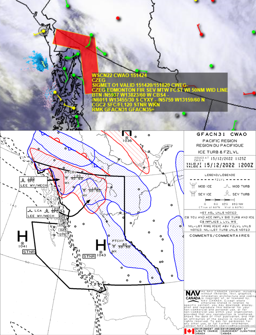
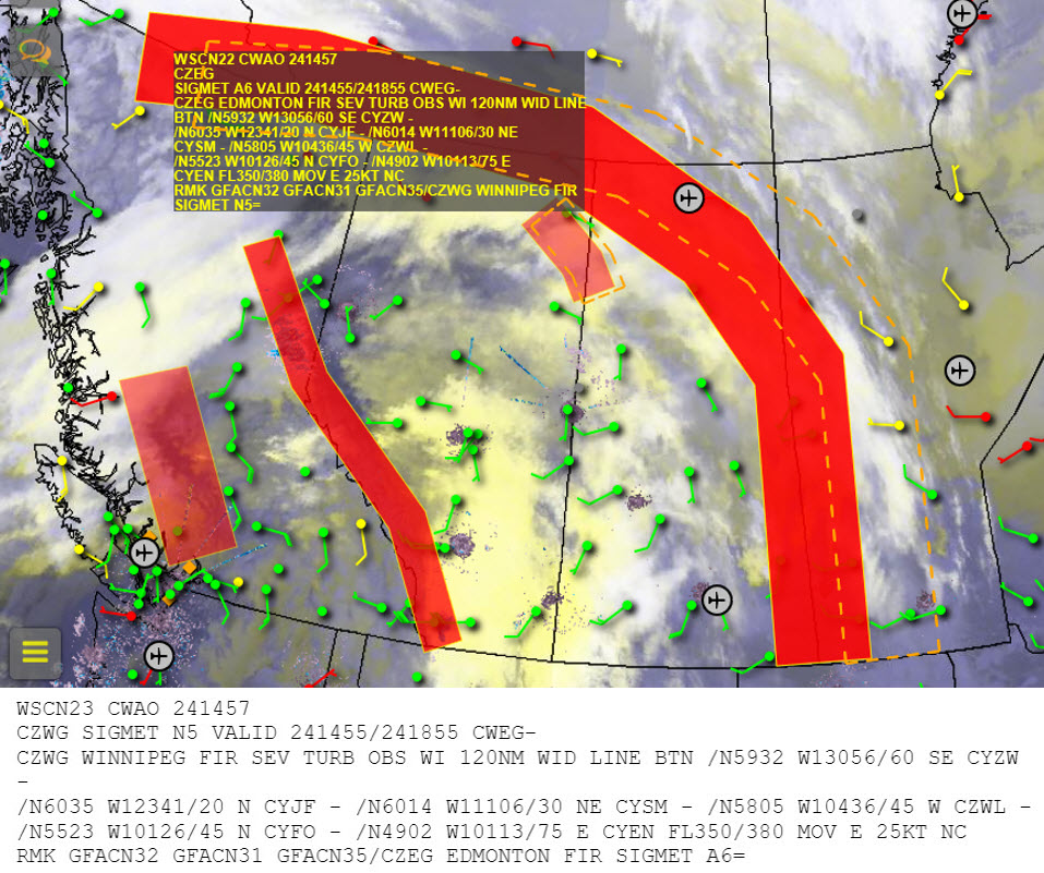
Similarly, this SIGMET for severe mountain wave turbulence sent over north coastal BC has no direct observations of turbulence (no PIREP). The forecasters predicted from a mix of the weather scenario, model data, and satellite signature (here, clouds in organized rows downstream of the mountains, although recall that satellite signature does not indicate severity), that is likely mountain wave turbulence was occurring in this region.
The associated GFA panel depicting SEV LEE WV and valid at 1200Z is shown.
Image Source: Environment and Climate Change Canada
A SIGMET can be transmitted as “observed” (OBS) as long as there is a recent direct (eg. METAR, PIREP, atmospheric sounding) or indirect (eg. radar, webcam) observation of the event, leading the forecaster to believe the phenomenon is present.
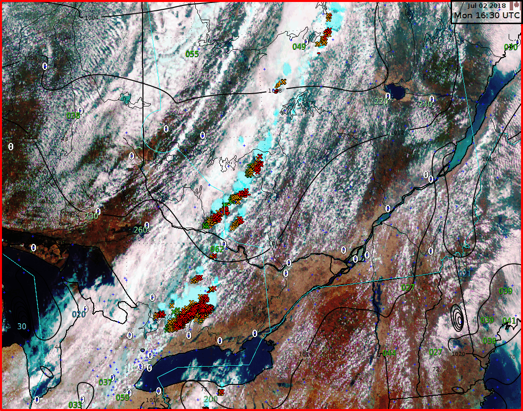
An organized line of thunderstorms passing through a region is easily observable from ground and remote sensing sources (Radar, Satellite, Canadian Lightning Detection Network) and can be assigned an OBS SIGMET quickly.
This is shown here in an example of a developing line of thunderstorms along a cold front as it sweeps through southern Ontario, central and southern Quebec.
Image Source: Environment and Climate Change Canada
Due to the widespread, high impact of the expected freezing precipitation, the forecasters transmit a SIGMET in order to ensure aviators knew which flight levels were most likely to be impacted by severe icing, shown on the left.
**Since SEV ICE SIGMETs cover a layer of the atmosphere (eg. SFC to FL030), the forecaster needs evidence of ICE at altitude in order to issue an OBS SIGMET. Since METARs and observations only verify surface conditions, ground reports of FZRA/PL are not considered “direct observation”, since they do not address the depth of the freezing layer. For this reason, most SEV ICE SIGMETs will be FCST instead of OBS.
Image Source: Environment and Climate Change Canada
Other SIGMETs are less obvious forms of evidence that contribute to them being observed. Such as shown in the image on the left, where we see an OBS SIGMET for CAT passing through northern BC/AB/SK and south through Manitoba, moving eastward. While there were no PIREPs corresponding to this SIGMET (that within the SIGMET does not match the flight levels of the warning), using other sources, such as atmospheric sounding wind profiles, the forecaster felt they had enough direct evidence to call the CAT OBS.
Image Source: Environment and Climate Change Canada
No aviation hazards are directly related to SIGMETs, but rather to the weather that requires their dissemination (see associated terms).
Operations Duty Managers
Current SIGMET information is provided at the start of each weather briefing to ATC unit supervisors.
Operations Duty Managers will check in with unit supervisors and ATC when a SIGMET is active in their airspace. This is done to maintain awareness and coordinate with neighboring ATC or the NTMU if needed. Potential impacts are also communicated directly to customers on the NOC call to facilitate planning and discuss any required actions from an ATFM perspective.
Forecast charts are also consulted and heads-up given to potential areas of interest for the shift. This includes analysis of GFAs, TAFs, HLT charts, TCF panels, and CoSPA. Analysis of these products support discussions:
Current observations are discussed and supplemented by current satellite/radar imagery and any PIREPs using the HubWX weather map.
ATC (Major Tower)
SIGMETs within terminal airspace and impacting the airfield provide crucial information of significant weather phenomena. Individual impacts vary based on the SIGMET: thunderstorms, severe icing, severe turbulence, etc. However, overall a SIGMET can increase communications with crews and can cause congestion on frequency. A controller’s workload will be increased.
ATC (Regional Tower)
SIGMET along the planned route of flight for departing aircraft are passed on them before departing and can be published on the ATIS for pilot info.
FIC
In the FIC, a SIGMET gets immediate attention, regardless of if based on Forecast or Observed conditions. The FISE Specialist will broadcast the SIGMET on all relevant frequencies and may call ATC to request relevant PIREPS to confirm the data. Each Specialist conducting briefings will take note of the geographical and altitude parameters of the SIGMET, to decide if it is relevant to each customer’s particular requirements (ie. A student pilot performing circuits at a small airport is not concerned with overhead CAT based at FL200).
AAS
Advisory Specialists are required to Broadcast on the MF any SIGMET within 20SM of the edge of the MF Area, up to 10000’ASL (or further as may be required). Specialists will always issue an updated ATIS with the new SIGMET information and solicit PIREPs more often to verify Observed conditions and confirm Forecasted ones to improve the data set for forecasters and briefing specialists.
At major airports, SIGMETs are included on the ATIS. Controllers will ensure that all arriving aircraft have the most current information. The most up to date conditions are generally passed from the terminal controller to the en-route controller and relayed to the pilots.
En-route controllers ensure that all pilots in their airspace are aware of a SIGMET, be it forecast or observed.
High level FL290 and +: SIGMET impacts can vary greatly depending on the type and the volume of traffic at that time.
SIGMETs impact the decisions on whether we open sectors or not, acceptance of SWAP routes, mileage in trail, etc. In some high level ATC units, SIGMETs within 100NM of their airspace must be passed along to crews. This is where situational awareness and receiving SIGMET information from forecast offices is imperative.
Generally speaking, we will focus on the location of the SIGMET and its consequences. For high level, the most important conditions to target are thunderstorms and CAT.
There can be confusion between forecast/observed SIGMETs when they are sent as observed while no associated PIREPs have actually been transmitted for the phenomenon.
The SIGMET database is checked prior to a shift and thoroughly evaluated prior to operations in and around an area with one present.
When a SIGMET is over a major airport there tend to be frequent PIREPS substantiating or downgrading the SIGMET which is key to maintaining a safe operation. Should the forecast weather be observed, significant irregular operations can occur.
SIGMET impacts may vary depending on aircraft type and size and as such, severe turbulence/icing for a light or medium sized propeller aircraft may not be the same for a larger jet aircraft.
Other than PIREPs, the Graphical Turbulence Guidance and Forecast Icing products are used from the Aviation Weather Center. For convection, CoSPA and TCF panels are additional resources among forecast products.
Most weather associated with a SIGMET constitutes a severe hazard for a General Aviation (GA) pilot. It is recommended to check this along with other pre-flight weather information gathering.
Using and being aware of the SIGMET before flight can greatly reduce the risk associated with encountering that type of weather.
Some weather criteria currently used in Canada do not always align with the risks related to light GA aircraft. Something that would be considered a moderate risk for a B737 could present a severe risk for a C172. For example, wind shear of 30 kts may be considered moderate, however could lead to severe turbulence in a light GA aircraft and/or easily lead to a loss of control. Therefore, it is very important to understand the limitations of weather reporting related to certain phenomena and how the relative risks can be different - both as a pilot decoding this information and as an air traffic service professional providing this information.
When a SIGMET is issued in flight, it is often noticed on a digital device (GPS, tablet, etc). If tuned to the correct frequency, pilots may also hear it as an FIC broadcast.