METAR Code
N/A
Weather Symbol
Aircraft turbulence can provoke physiological discomfort (fatigue, nausea, vision difficulties, strains), handling problems (yawing, pitching and rolling from uneven accelerations, changing airspeed and vertical accelerations, stalling, and loss of control), and structural stresses on the aircraft.
High level (generally above FL180) wind shear turbulence associated with the jet stream. Instantaneous wind speeds exhibit irregular variations that cause erratic bumpiness, ascent and subsidence and rapid changes which can result in a significant gain or loss of airspeed.
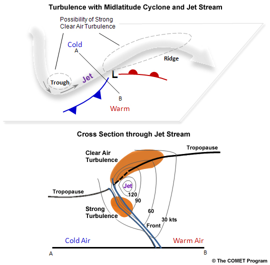
The figure on the left shows likely locations for clear air turbulence development. In the jet cross section, thin black lines around the jet are lines of constant speed, with the jet core being the maximum wind. Blue lines extending toward the surface are frontal boundaries.
Clear air turbulence is associated with rapid changes in wind speed generally within 4 degrees latitude or 180nm of the jet stream.
The following are the primary upper air considerations associated with the production of moderate or greater clear air turbulence:
Image Source: COMETOpen a new window
There are certain areas within the jet stream that are more likely to have moderate to severe turbulence. These areas are the following:
Clear air turbulence is generally reported between FL180-FL420 due to these being heights in which the jet stream generally resides. Pilots can however also experience mountain wave or convective turbulence at these heights. We can thus generally determine the type of turbulence experienced at these flight levels based on the aircrafts position relative to a mountain range, convective cells and the jet stream.
Image Source: COMETOpen a new window
Dissipation
Clear air turbulence will become less severe when the winds in the jet stream weaken or when the jet stream becomes more zonal (when there are less ridges and troughs within the jet stream).
Duration
Clear air turbulence is somewhat irregular in nature and thus if a pilot chooses to fly a few thousand feet higher or lower than where they experienced turbulence or tens of miles farther away from the area of maximum winds, they can find themselves in more stable airflow and limit the turbulence they are encountering.
The conditions in which clear air turbulence can exist, since they are dependent on large scale features, can last up to a few days. However, strength of the turbulence can fluctuate during its lifetime.
The jet stream will generally be stronger in the winter months due to the larger temperature difference between the poles and the equator. With stronger jet streams we have stronger winds and thus are more likely to encounter clear air turbulence in the winter months. Recent studies have indicated that climate change will likely increase the occurrences and extent of clear air turbulence as temperature extremes become more common across the globe.
As you will see in the examples, turbulence PIREPs are incredibly useful for forecasters to confirm a suspected area turbulence. Pilots are encouraged to issue PIREPs to help maintain the safety of the air navigation system.
The severity of clear air turbulence is somewhat subjective, which can make it difficult for a forecaster to predict the severity that would be reported by an aircraft flying through a likely turbulent area. While forecasters scientifically associate certain wind shear values with moderate and severe turbulence, however, it is evident that various aircraft will experience these thresholds in differently (large aircraft are usually less sensitive to turbulence).
When clear air turbulence is expected, a severe turbulence SIGMET will be issued. If the forecaster receives a PIREP confirming the location of the clear air turbulence, with SIGMET will be an ‘observed’ SIGMET. If the SIGMET is based on model guidance and satellite imagery indicators, the SIGMET will be issued as a ‘forecast’ SIGMET.
Clear air turbulence will often be forecast close to the jet maxima. Model guidance usually over-forecast regions of clear air turbulence, and satellite signatures not do not necessarily indicate the severity of CAT within the air mass. Forecasters rely heavily on PIREPs to validate CAT forecasts, which are often unavailable since pilots will avoid encountering turbulence when able. Forecast clear air turbulence SIGMETs are scrutinized before transmission, as meteorologists are cognizant that large SIGMETs at high altitude can compromise many flight paths.
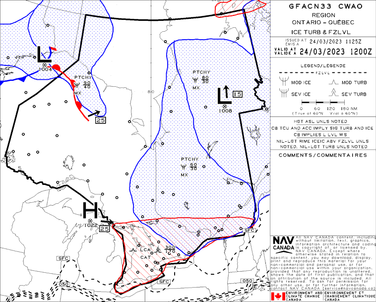
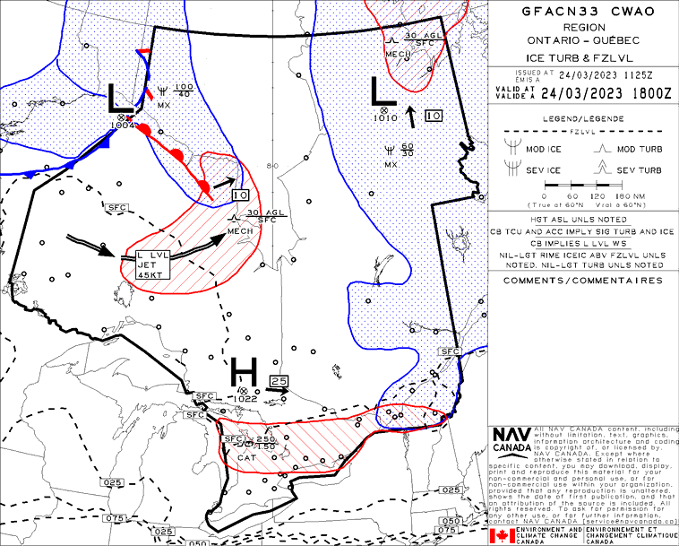
When forecast, CAT can be found on icing and turbulence GFA panels when the base of the CAT begins below 24,000ft, as shown here in an example on March 24, 2023. At 1200Z that day, southern Ontario was forecast to see moderate CAT between 17,000-30,000ft (FL170-300), with risk of local severe CAT conditions as indicated by the severe symbol.
By 1800Z, the icing/turbulence GFA panel indicates the zone of CAT forecast has weakened with no severe expected, has shrunk in size, and has also seen its altitude change to between FL150-250.
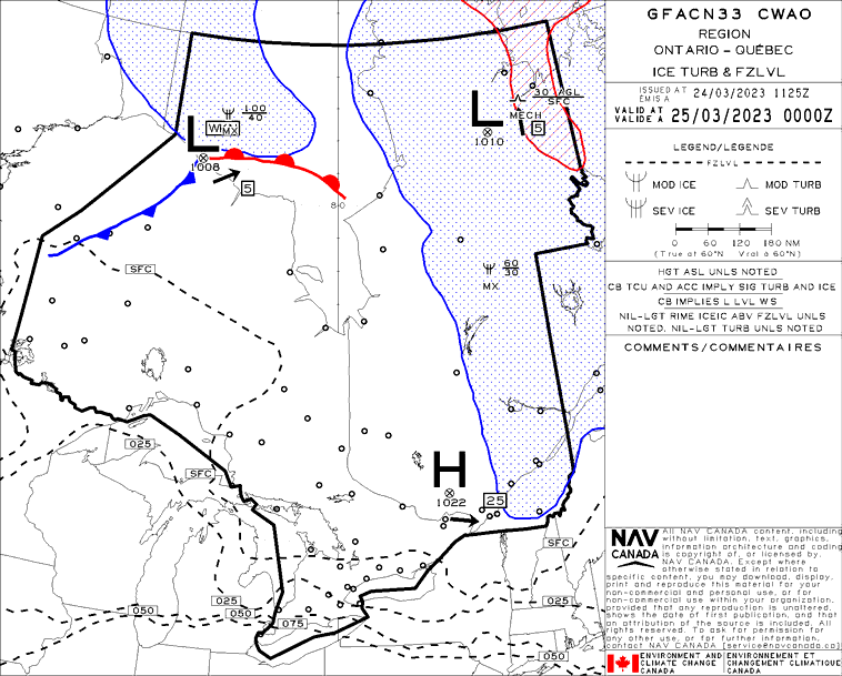
The zone of CAT possible within the flight levels captured by the GFA (below FL240) is forecast to dissipate entirely by 0000Z over the GFA area, as no areas are indicated on the final panel. Of note: forecast CAT that is expected to occur above FL240 will not be shown in GFA panels but will instead be found in high-level turbulence charts (HLTs).
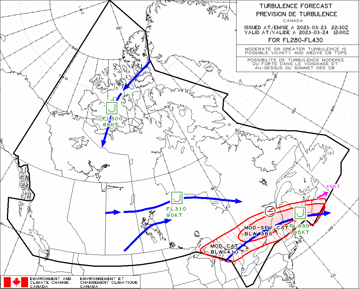
The Canadian high-level turbulence chart issued at 2230Z on March 23, 2023 and valid at 1200Z on March 24, 2023 indicates a wide area of both moderate and moderate-to-severe CAT across southern Ontario and southern Quebec. This area is correlated to a 195KT jet core at FL330, with the strongest area of moderate-to-severe CAT forecast closest to the core of the jet at FL380 and below (to FL280), as described in the cross-sectional diagram in the science explained section. This forecast initially indicated an eastward motion at 45KT and that CAT was expected to be weakening. These features support the general areas indicated in GFA panels, though it is important to note that GFAs and HLT charts are created for different levels of the atmosphere. GFAs include weather up to FL240, though convection/turbulence will be included if/when the base of their occurrence falls below FL240. HLT charts cover FL280-430. Hence, when CAT is referenced as forecast BLW 380, this means it is forecast with bases that are below the bottom level of the chart. This is why turbulence forecast above FL240 may appear in an HLT but not on a GFA, as was the case here.
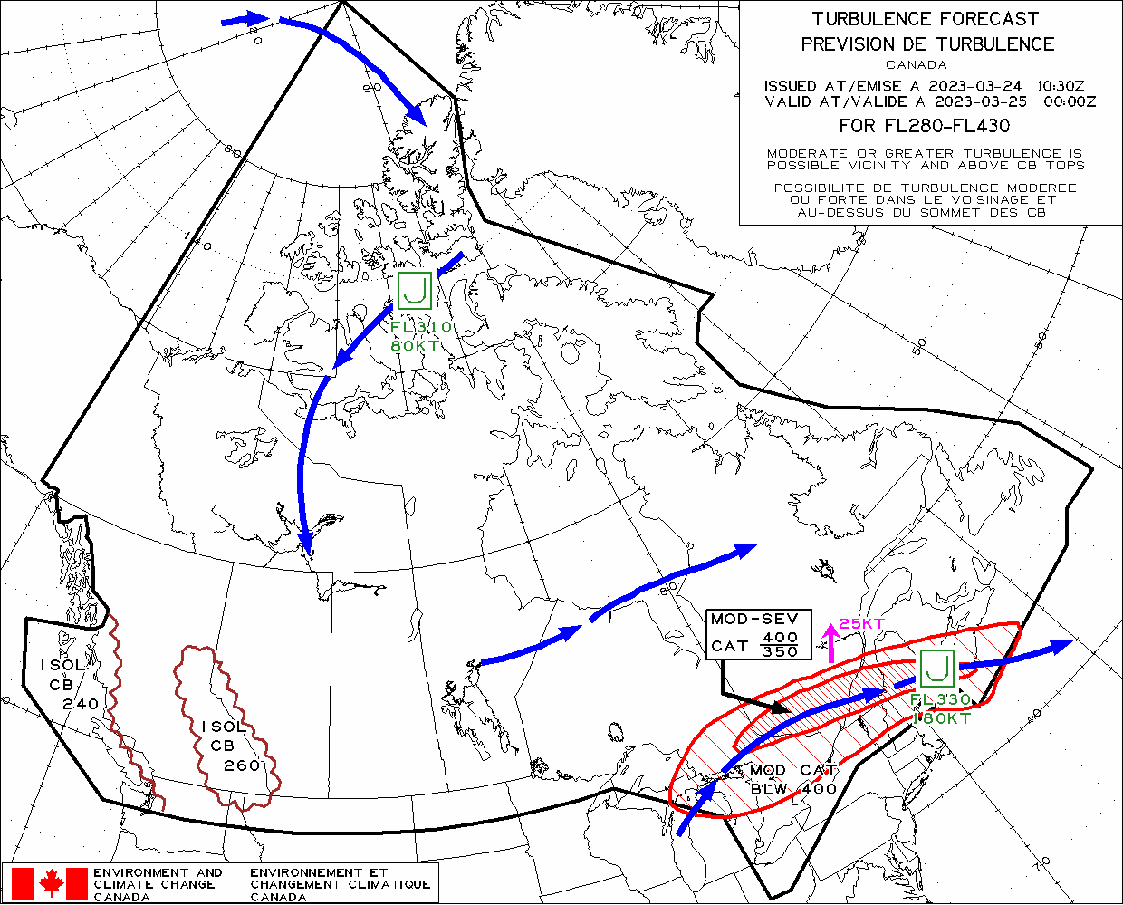
This HLT chart issued at 1200Z on March 24, 2023 and valid at 0000Z on March 25, 2023 shows the same general area of CAT across the region, though its trajectory now has more of a northeasterly component at 25KT rather than eastward at 45KT. By 0000Z the GFA panels no longer indicate any CAT below FL240, which is supported on the HLT charts with impacted flight levels being in the FL280-400 for moderate turbulence and FL250-400 for moderate-to-severe. The forecast also changed slightly in its intensity, with no symbol indicating the possibility of weakening. However, the jet core should be noted as its core speed has begun to drop from 195KT to 180KT over that 12hr period.
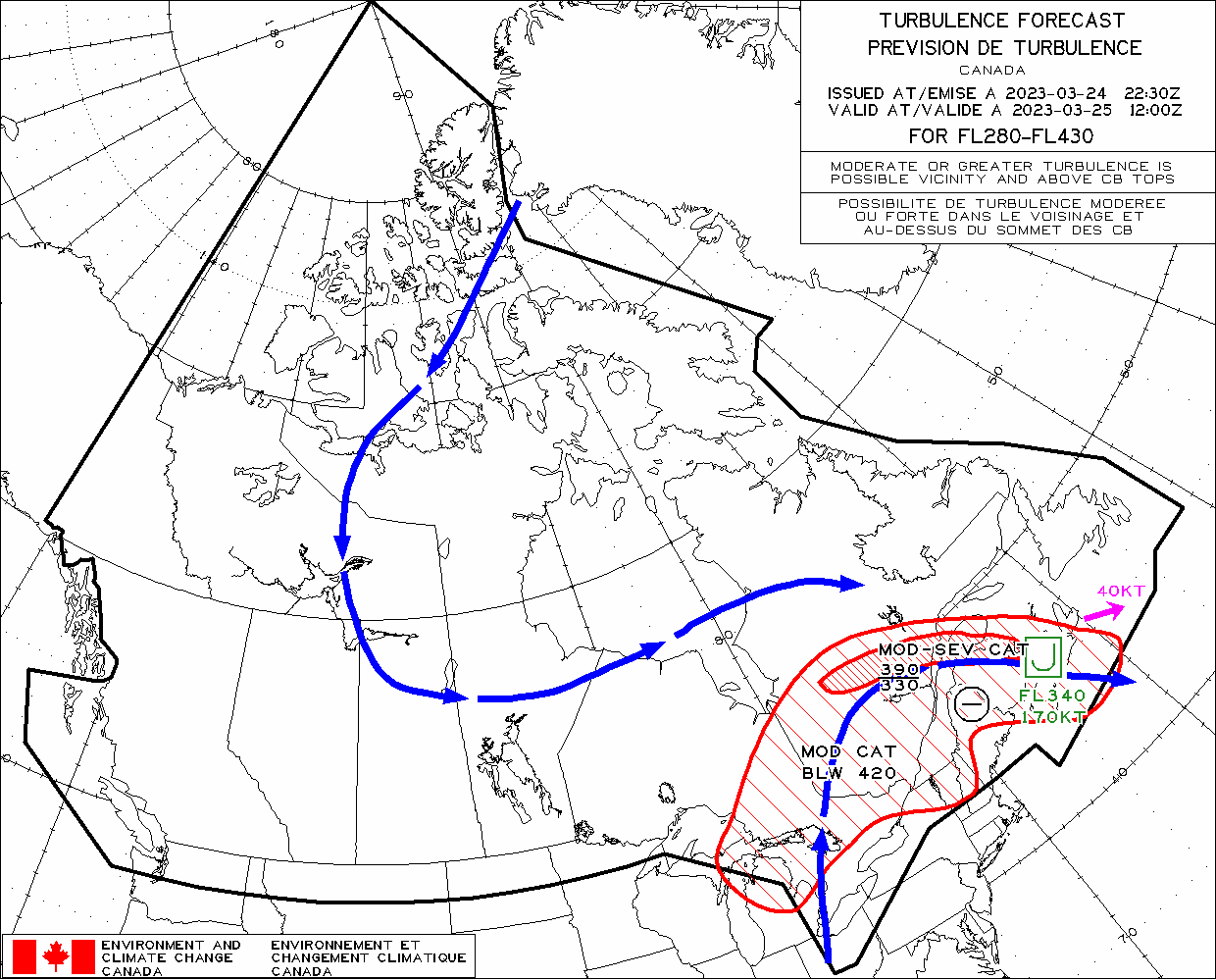
The final panel shown is the issued HLT forecast at 2230Z on March 24, 2023 and valid at 1200Z on March 25, 2023. The clockwise (anticyclonic) curvature of the upper-level jet has amplified, and as shown in the science explained section, can be associated with areas of severe CAT. Though moderate-to-severe CAT is forecast, there is also a weakening trend forecast as the jet core is shown to continue to weaken. Across the three panels shown, the core speed has dropped from 195KT to 170KT by 1200Z on the 25th. This weakening of maximum wind speeds changes the magnitude of wind speed decelerations and potential vertical wind shear thresholds needed for moderate to severe turbulence.
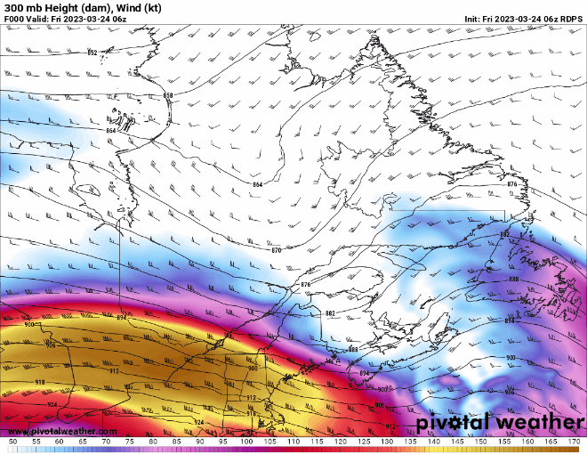
This is an animated GIF of winds (knots) at 300mb, approximately FL310, taken from the RDPS weather forecast model data. The date and time for which each timestep is valid is indicated in the top left corner in Zulu time. From the science explained section, zones of CAT are often collocated with upper-level jet streaks/jet cores and upstream of a sharp ridge. Winds within the yellow and dark yellow bands are greater than 140KT and indicate the jet core. These zones, when favouring CAT, will be highlighted in forecast products for users (see next images). The area of CAT seen in the GFA dissipates below FL240 by 0000Z on the 25th. Assessing the 300mb winds, we can see that the winds are weakening dramatically over southern Ontario and southern Quebec between 24/2100Z and 25/0300Z, as the jet core translates over the Maritimes with the amplification of the ridge. As shown in the HLT forecast charts, the core of the jet weakens over time, which will impact the magnitude of wind speed changes both horizontally and vertically and as a result change the probability of CAT occurring. This is reflected by the weakening symbol on the final HLT chart shown, valid at 1200Z on March 25, 2023.
Image Source: Pivotal Weather
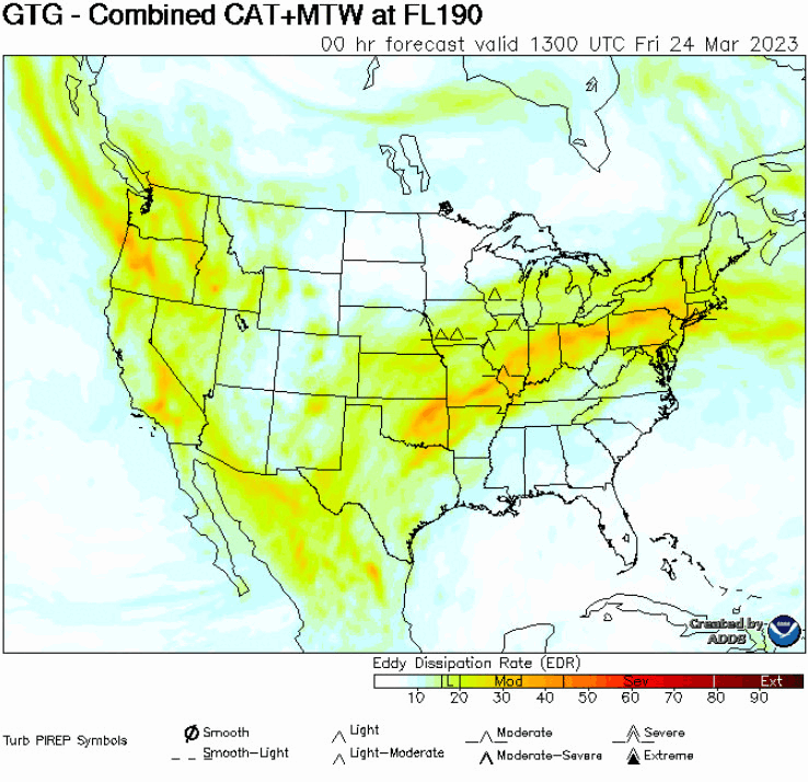
The Eddy Dissipation Rate (EDR) is another metric that can be used to diagnose the areas of potential turbulence, including CAT.
The forecast on March 24, 2023 at 1300Z from FL190 through FL430 supports the 1200Z GFA graphical analysis, which suggests the moderate to severe turbulence is mainly within FL170-300. This forecast was also supported by PIREPs of severe turbulence at FL250. Assessing the location of the most significant turbulence with the location of the 300mb jet core (previous image) shows a strong correlation between the two.
Image Source: Aviation Weather Center
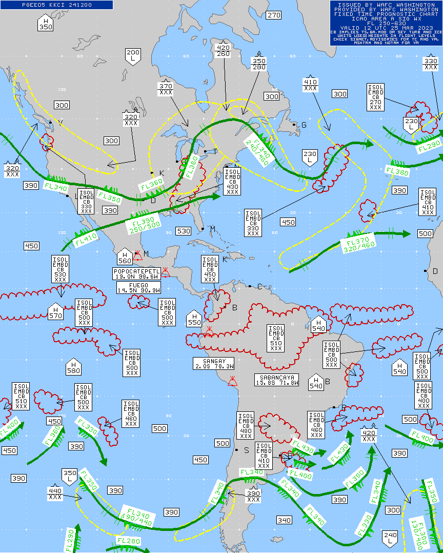
This prog chart is the high level significant weather chart, valid at 1200Z on March 25 – 23, issued by the World Area Forecast Centre Washington. The science explained section highlighted that one particular location favouring CAT is downstream of a sharp ridge, in the area of greatest anticyclonic curvature. This is evident in this example, with the strongly curved jet over Eastern North America and the area of severe CAT forecast between FL280-350, from East-Central Quebec over the Gaspé Peninsula and into the Maritimes. This zone of severe CAT is just downstream of the peak curvature of the jet.
Image Source: Aviation Weather CenterOpen a new window
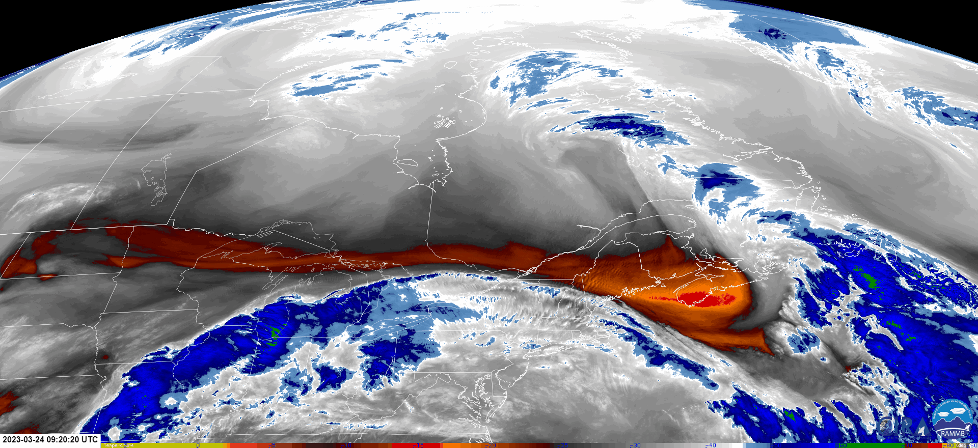
This is a satellite imagery loop of enhanced mid-level water vapor on March 24, 2023 between 0920-1500Z. Water vapor satellite imagery often provides forecasters with the best glimpse of classic CAT signatures. In this loop, we can see transverse banding across Southern Ontario, extreme Southern Quebec, and the upper Northeastern United States. It should be noted that the lack of these signatures on satellite imagery does not mean that CAT is not occurring, as there are several satellite features to look for when assessing CAT and its strength. Instead, forecasters will look to satellite imagery in conjunction with PIREPs and model data (graphical products, soundings, etc.) to diagnose regions most likely to see turbulence.
Image Source: CIRAOpen a new window
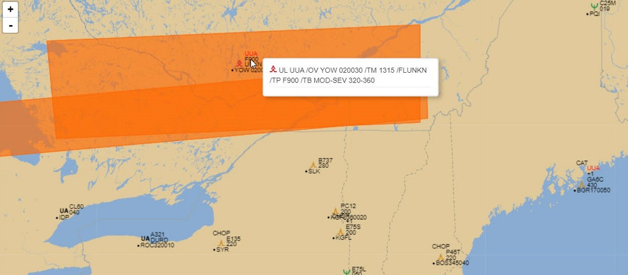
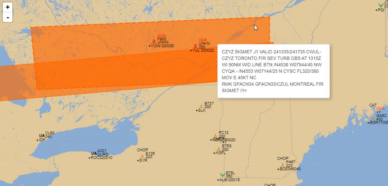
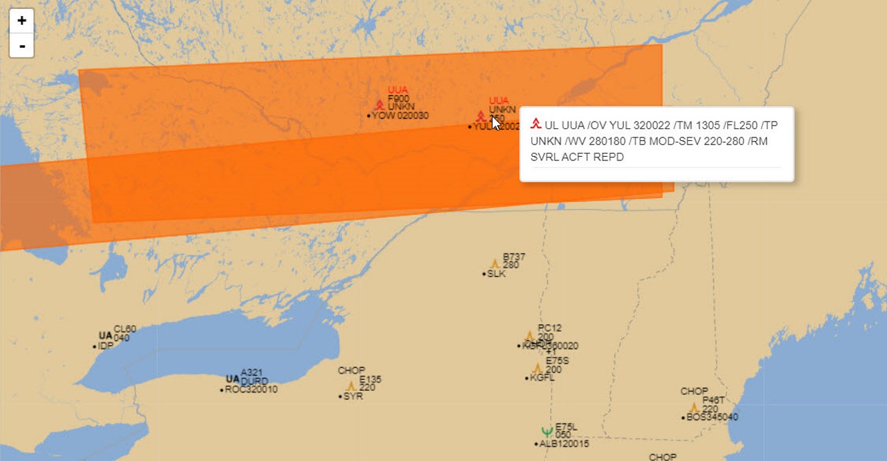
The GFA and Canadian HLT charts both indicated the possibility of locally severe CAT, and this forecast verified as PIREPs were received in the forecast area. PIREPs are a forecaster’s best tool when assessing the accuracy of model data and the likelihood of impactful weather phenomena in areas that lack in-situ observations. As safety is priority #1, forecasters will anticipate areas and indicate these across various forecast products, and issue forecast SIGMETs when specific conditions are met. This is especially the case in-flight, which is why both urgent and non-urgent PIREPs can greatly help in determining the location and intensity of specific phenomena. This first PIREP, transmitted at 1315Z, indicates the crew experienced moderate to severe turbulence between FL320-360. Forecasters will assess all PIREPs received to then issue observed SIGMETs when specific conditions are met.
This screenshot taken at 1429Z on March 24, 2023 shows two active SIGMETs for severe turbulence over Southern Ontario and Southern Quebec as a result of conditions supporting CAT across the area. The northernmost SIGMET, J1, is collocated with the PIREP shown above, covering FL320-380 in the area that forecasters correlated to model data and satellite imagery signatures.
A second PIREP, issued at 1305Z includes the reports of moderate to severe turbulence between FL220-280 by multiple aircraft in the remarks section. This crucial information allows for forecasters to assess the turbulence in the area, tie it back to where CAT is, and issue the proper SIGMET that covers the impacted area. This area of CAT was also included in the original forecast issued in both the GFAs and HLT charts.
The second, more southern SIGMET is H1. This observed SIGMET between FL200-280 was issued as a result of the received PIREPs for severe turbulence. This level of specificity including difference in altitude and different areas/dimensions are a result of the forecaster’s level of detail when assessing specific zones of potentially severe turbulence.
Turbulence, airframe damage, possible air sickness and/or injury to passengers on-board.
Operations Duty Managers
Increased workload for ATC due to issuing turbulence reports and finding alternate altitudes.
High level weather is always included in the supervisor briefings, which occur regularly for all ATC unit supervisors and the on-duty ACC Operations Duty Manager. Charts used in these briefings:
NTMU would take no specific action for CAT, other than having discussions with sector supervisors when it may impact holding capabilities.
For enroute also no action, other than if would be pointed out to sector supervisors if discussing taking on additional traffic such as CAN Routes.
FIC
At Flight Information Centres which have FISE duties, an effective weather watch must include awareness of potential CAT-producing high-altitude phenomena. This includes, but is not limited to, the track of jet streams including areas of significant change in wind velocity (sharp bends can produce areas of significant shear turbulence). Once detected, the Enroute FISE Specialist will advise the relevant Area Control Centre (ACC) Sector of their analysis and request detailed PIREPS to confirm the presence (or absence) of CAT. The sooner these PIREPS are disseminated, dispatchers, controllers and ATM can make appropriate adjustments to route management for safety, and Canadian Meteorological Aviation Centre meteorologists can issue observed SIGMETs if required.
With strong westerly flows across the Rocky Mountains, gravity waves can propagate as far as 350 miles downstream, extending well into Saskatchewan airspace. One would anticipate these effects associated with lenticular clouds, but a deep dry airmass may leave an observer with no visual cue as to the presence or intensity of flow aloft, until actually entering the area of CAT.
Knowledge of the active Synoptic features upstream and within the area of responsibility, attention to any related SIGMETS, monitoring/soliciting PIREPS and keeping an eye on Satellite Imagery for telltale signs of upstream Mountain Wave activity assist FSS in early detection of potential mid-level CAT development.
Clear air turbulence does not often impact day-to-day operations for low level en-route. When receiving a daily weather briefing, controllers will be aware of the possibility that some CAT can occur. A controller will ask pilots for PIREPs in the forecast areas and, if there is some turbulence, pass the information to other aircraft.
The tools of choice for the CAT are the high level wind charts, turbulence forecasts, as well as the forecast of the jet current since the lateral limits of the latter are often associated with CAT zones.
This weather condition is a high-impact and often seen occurrence in high-level airspace that occurs almost daily.
In the absence of a defined zone of CAT, it can be challenging for ATC to determine optimal altitude deviations that might improve flight conditions. This is where pilot reports become integral. With those, users can be notified in a timely manner and flight paths modified by changing altitude and/or route when possible.
CAT is an important consideration for a DX’s flight plan and in general the following priorities are observed when planning in and around CAT:
Many weather forecasting products are used to determine where CAT may be present- the most common products are:
Efforts are made to avoid mod-severe turbulence as much as possible which generally require:
PIREPS are important when trying to find the smoothest flying levels. While there are many aircraft operating through a specific area of airspace, PIREPS aren’t always formally input into the general aviation network so getting a collection of PIREPS requires an active search like calling other carriers / ATC.
Clear air turbulence is often experienced when crossing a jet stream. Similar to mountain waves, dispatch is relied on to advise pilots of areas of known CAT. Pilots are operationally restricted to enter an area of reported severe turbulence.
Jet stream turbulence is not common for turboprop aircraft as the jet stream is usually at an altitude above the certified ceiling. On occasion a low level jet stream can be encountered in the lower flight levels, usually during the winter months.
Turbulence forecasts (higher flight levels), SIGMETS, pilot and ATC reports are ways pilots avoid clear air turbulence. High shear values on the company flight planning software may indicate turbulence as well. Ride reports are helpful to determine the best altitudes to avoid clear air turbulence.
Pilot actions when encountering CAT:
One of the main aspects of flight planning we spend time on for passenger flights is turbulence. From publicly available information, we will look at SIGMETs, PIREPs and High SigWx charts. Typically, those will focus on high severity occurrences (moderate to severe turbulence), although we also take into consideration light to moderate chop in our planning. Also, moderate turbulence is not always captured by high SigWx charts. Airlines will also have other products available (eg: WSI) which will be considered. Below is more detailed information, shared as these tools are part of everyday operations, during flight planning and in flight, though the specific tools used and available varies depending on the company.
For a flight, we take all those sources into account to assess turbulence, hence this long enumeration. If only one source suggests significant turbulence in an area, we might keep it in the back of our mind, but we might not plan around it. When multiple sources are correlated and showing moderate to severe turbulence in an area, that's when we start planning around the area, or at a different altitude. If uncertainty exists due to disagreements in between sources, our dispatcher can add contingency fuel to give us leeway to change altitude to avoid reported turbulence. For a medium or long-haul flight, the dispatcher's flight planning might have been done 6 hours or even more before flying to an area where there is a potential of turbulence. Adding contingency fuel for turbulence is the most appropriate mitigation flight planning element in that case.
For jet-stream or orographic generated CAT, reports from other pilots will be our most reliable source for avoidance. Those reports are live data for an area and will help us decide which altitude will be more suitable to fly at.
High altitude CAT area generated by thunderstorm cells will be typically downwind, and near or above the top of the anvil. As we approach a cell, we will use our airborne radar to look at which route shows less precipitation return, but also take into consideration the winds aloft to avoid passing downwind of the cell, preferably. If we deviate upwind, we will be evaluating our altitude relative to the top of the anvil. If we are above the anvil and there is an overshooting top, those are the conditions when we can expect turbulence downwind of the cell. The resulting flow around an overshooting top could be compared to a wind blowing above and around a mountain. We can observe small lenticular clouds. If the flow is laminar, the flight condition can be like a mountain wave area. Further downwind will be the safer option but the flow is more likely to have become turbulent. We can use the same mitigation strategy if we expect the area to be turbulent: fly to an airspeed which gives us the safest margin, put the seat belts sign on pre-emptively.
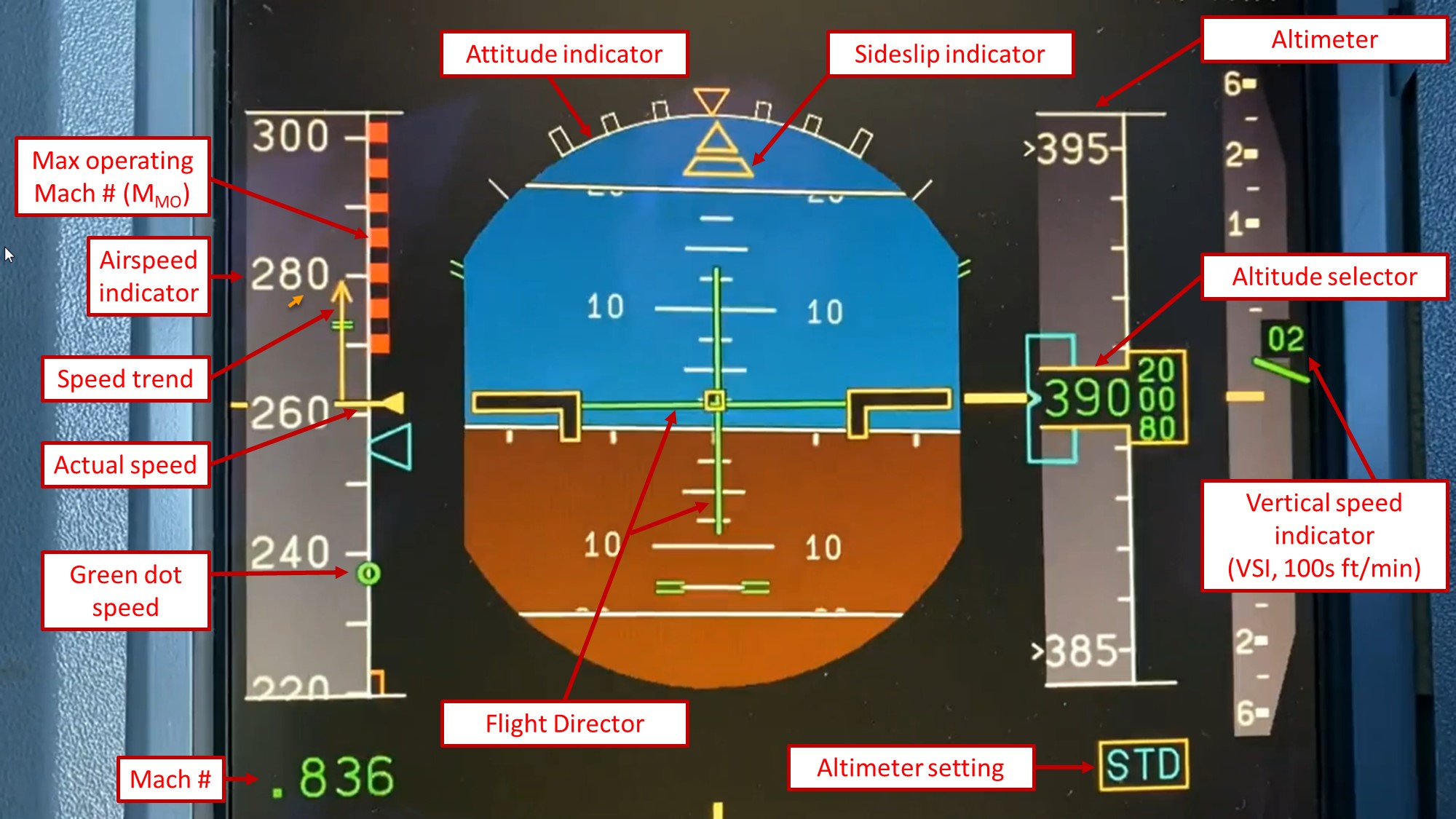
This still image is a snapshot of an Airbus 330 Primary Flight Display, with most critical variables for CAT defined in red boxes. An animation is shown in the next image on the carousel. The speed trend arrow shows the speed in 10s, and varies greatly in turbulence. Though it can have some lag, it is still a good indication. The green dot speed provides a crew with the best lift-to-drag ratio speed. Descending below that speed results in the aircraft requiring more thrust, and is not recommended as it can be difficult to exit. Green dot speed and the MMO are the two most important factors crews have to consider for what is known as coffin corner (shown in this carousel).
Image Source: @YYZBound Twitter
This animation of a Primary Flight Display for the A330 shows the aircraft in moderate chop over southern Manitoba on September 27, 2023. Of note:
In this event, all altitudes were reporting moderate chop. Otherwise the crew will request a smoother altitude to either climb or descend to. Crews can also manage speed in response to turbulence occurrence.
Image Source: @YYZBound Twitter
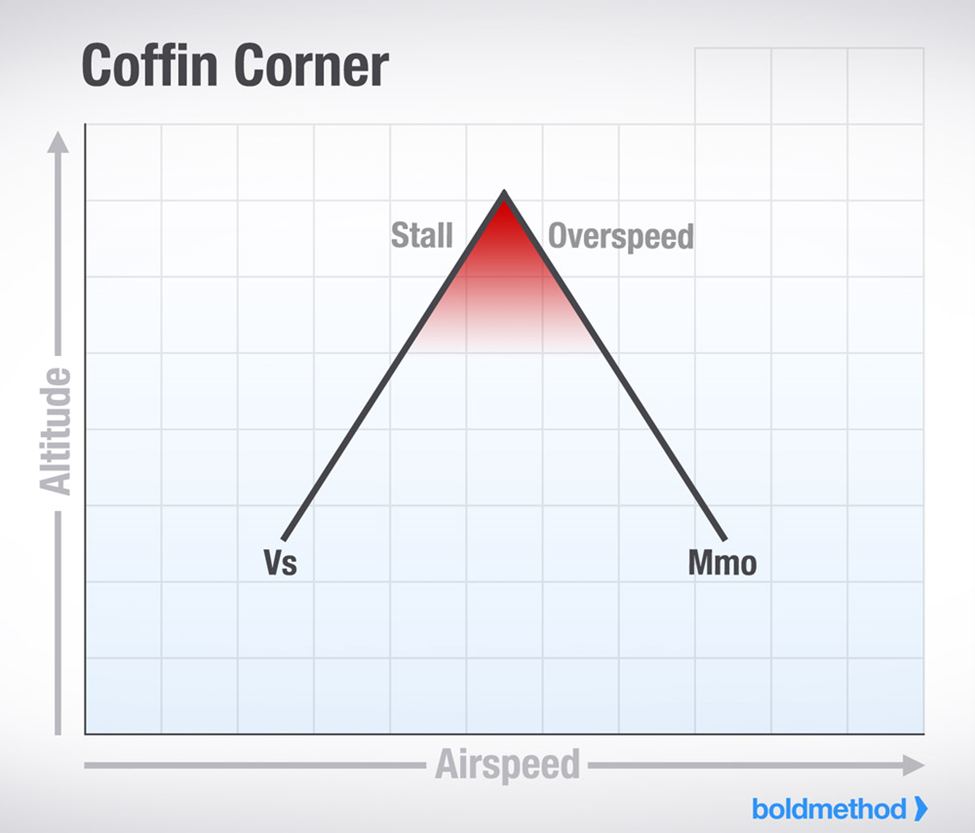
Coffin cornerOpen a new window will be a concern with CAT as well. With moderate or severe clear air turbulence, wave activity can also be present and generate speed variations which can be hazardous, similarly to mountain wave activity. In addition, turbulence can create variation in the load factor. If the load factor increases, the stall speed will also increase. With a limited buffer, stall protection systems can be triggered with significant turbulence. The ideal mitigation technique in this case is to descend lower to increase the margin.
Image Source: Bold Method