METAR Code
-SN/SN/+SN or -SHSN/SHSN/+SHSN
Weather Symbol

The two main impacts of snow are reduced visibility conditions (both from falling snow and blowing snow that may be associated), and snow accumulation, both of which can affect aviation operations in a variety of ways.
Additionally, snowfall accumulation on aircraft can affect control during takeoff and landing and can also contribute to the formation of ice on aircraft surfaces such as the wings, tail and control surfaces.
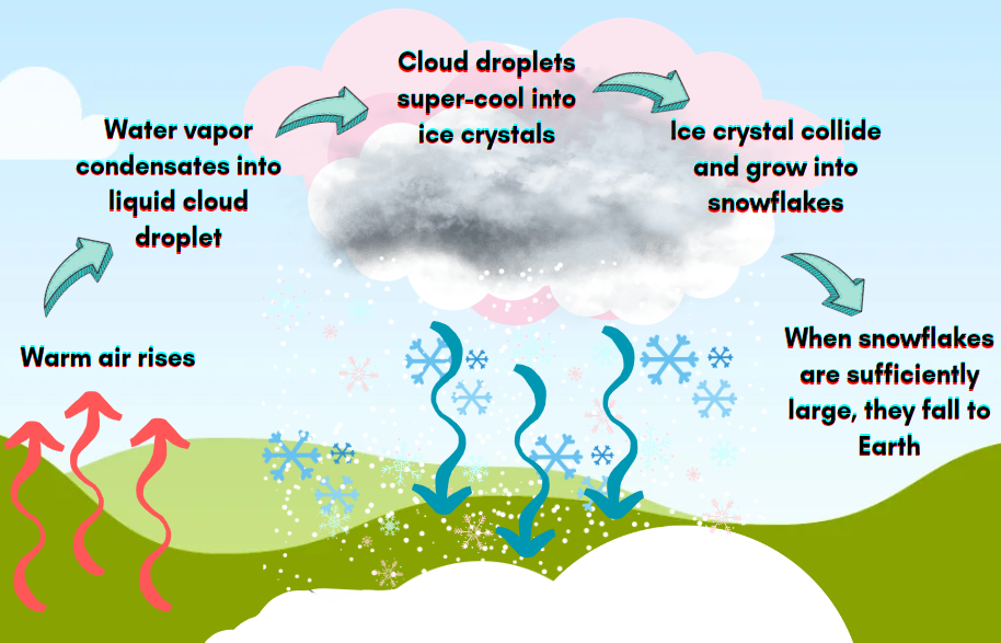
Frozen precipitation in the form of white or translucent ice crystals in complex branched hexagonal form. It most often falls from stratiform clouds but can fall as snow showers from cumuliform ones. At temperatures > than -5°C, the crystals generally cluster to form snowflakes. (MANOBS 13.2.14)
Associated terms coming soon:
Dewpoint, lake effect, low-pressure system, orographic life, and upslope flow are all terms associated with snow that will be coming soon to the Aviation Meteorology Reference.
When forecasting snow, there are two main factors that are of highest importance, being reduced visibility, and snow accumulations. To produce snow, all that is required is a sufficiently cold and moist air column, which are abundant during cold winter months. There are basically two classes of precipitation: stratiform and convective.
Generally speaking, stratiform precipitation forms in synoptic systems (low-pressure systems and troughs) or in upslope flow. Lows and troughs are broad areas of upward vertical motion which causes air to lift, expand, cool, and saturate. In the cloud, once temperatures dip toward -10 degrees Celsius, there will be a mixture of water droplets and ice crystals. Snowflakes form by these water droplets sticking to ice crystals and growing until they are heavy enough to fall.
Upslope flow can also lead to snow development. For this, the upward motion is generally more rapid, but shallower, dropping precipitation at the top of (significant) terrain in sub-zero temperatures often associated with altitude.
Stratiform snow is usually widespread and continuous/intermittent depending on the storm structure. Generally, stratiform snow is often light to moderate, but can be heavier due to embedded convection associated with frontal features.
Lastly, convective clouds (TCU, ACC, CB) can produce snow showers. These shorter duration show events give light to heavy snowfall rates, rapid drops in visibility, depending on the level of instability and moisture available.
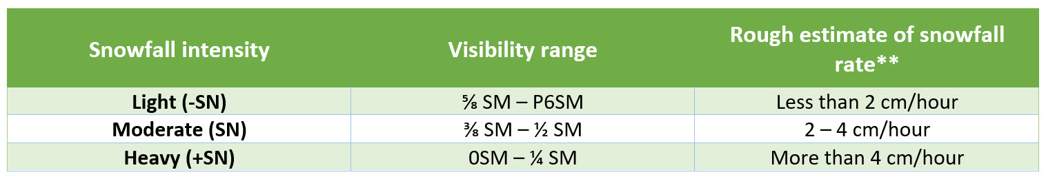
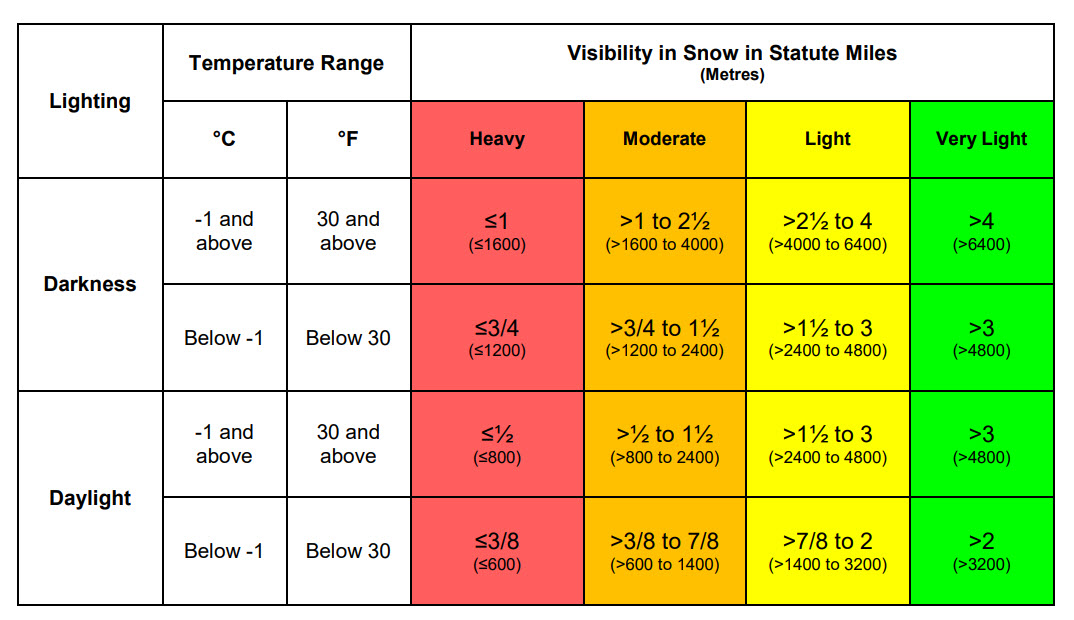
This table provides a rough estimate of snowfall rates based on snowfall intensity and visibility range.
Table source: Environment and Climate Change Canada
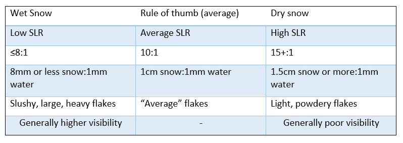
When the necessary ingredients are available for snow formation, the temperature profile of the atmosphere must then be assessed to help determine the snow-to-liquid ratio (SLR). This value is critical in determining snow characteristics (wet or dry), which impacts accumulations.
SLR is the amount of snow that can be melted down to a 1 mm-depth of liquid water.
A low SLR means that a smaller amount of snow will melt down to 1 mm of liquid water. Small SLRs will generate wet snow with large masses of snowflakes stuck together and is typically generated in warmer (near 0 degrees Celsius), humid air masses. In this environment, there is more water available to make more snow with higher water content, making heavier snowflakes heavier, which accumulate less rapidly as they are far denser due to their high-water content. Low snow-to-liquid ratios translate into higher visibility in absence of other contributing factors.
Alternatively, a high SLR means a lot of snow is required to melt to 1 mm of liquid water. Snowflakes generated in cold air will be small, powdery snowflakes that don't stick together. This 'dry' snow accumulates faster and is more prone to being affected by wind, leading to drifting or blowing snow, further deteriorating conditions due to poor visibility. High snow-to-liquid ratios translate into lower visibility in absence of other contributing factors.
Source: MetOffice UKOpen a new window
As temperature profiles can vary within a low-pressure system, SLR and precipitation rates can vary widely across the system. Where snow is enhanced within a low-pressure system is dependent on many factors, including embedded convection and air mass temperature.
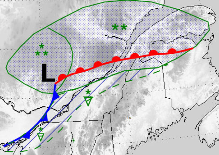
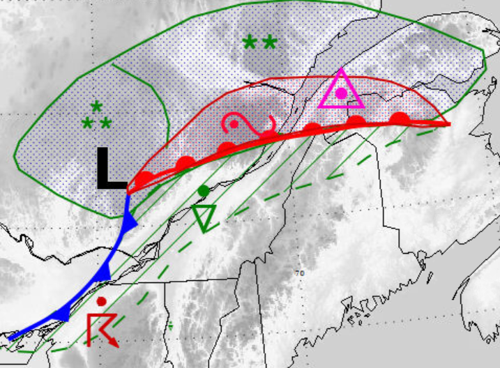
Snowfall rates are typically higher along frontal boundaries (warm front, cold front, trowal, troughs) where vertical motion is enhanced (shown here in a mock diagram of a low). Furthermore, snowfall rates are enhanced where convection is embedded in the stratiform snow (which may also occur along a frontal boundary). The area of heaviest snowfall, however, is often the northwest quadrant of the low pressure center (where there is strong vertical motion). Other phenomena that contribute to increased snowfall rates include local topography. For example, orographic lift due to elevated terrain will enhance snowfall rates as well as bodies of water that produce lake effect precipitation will experience increased snowfall.
Image source: Environment and Climate Change Canada
Snow-to-liquid ratios will also vary across a low-pressure system. SLR drops closer to the warm front where temperatures are higher, generally giving heavy, wet snow. Conversely, SLR tends to be highest where there is an influx of cold air, often in the northwest flow of the low.
It is important to note however, that high SLR does not necessarily mean high accumulations are expected, nor does low SLR mean low accumulations. Snow-to-liquid ratios aid in determining the type of snow expected at the surface, and how it might accumulate.
Image source: Environment and Climate Change Canada
Dissipation
Snow can dissipate for a variety of reasons. Stratiform snow will begin to fizzle out when there is no longer adequate moisture to generate snow being fed into the system. In the case of upslope flow, when the wind shifts away from terrain, or there is a change in air mass bringing in drier air (cutting off moisture inflow), snow will taper off.
In the case of convective snow, when supported by frontal features (or troughs), snow showers will weaken with dissipating fronts. Convection will otherwise exhaust itself once the influx of moisture has stopped and been precipitated out.
Duration
A snow event associated with a low-pressure system could last a couple hours up to a few days depending on the trajectory of the system. Upslope flow generated snow can persist for several hours, until wind direction shifts or there is a change in air mass.
Meanwhile, convective snow showers are relatively short in duration and sporadic.
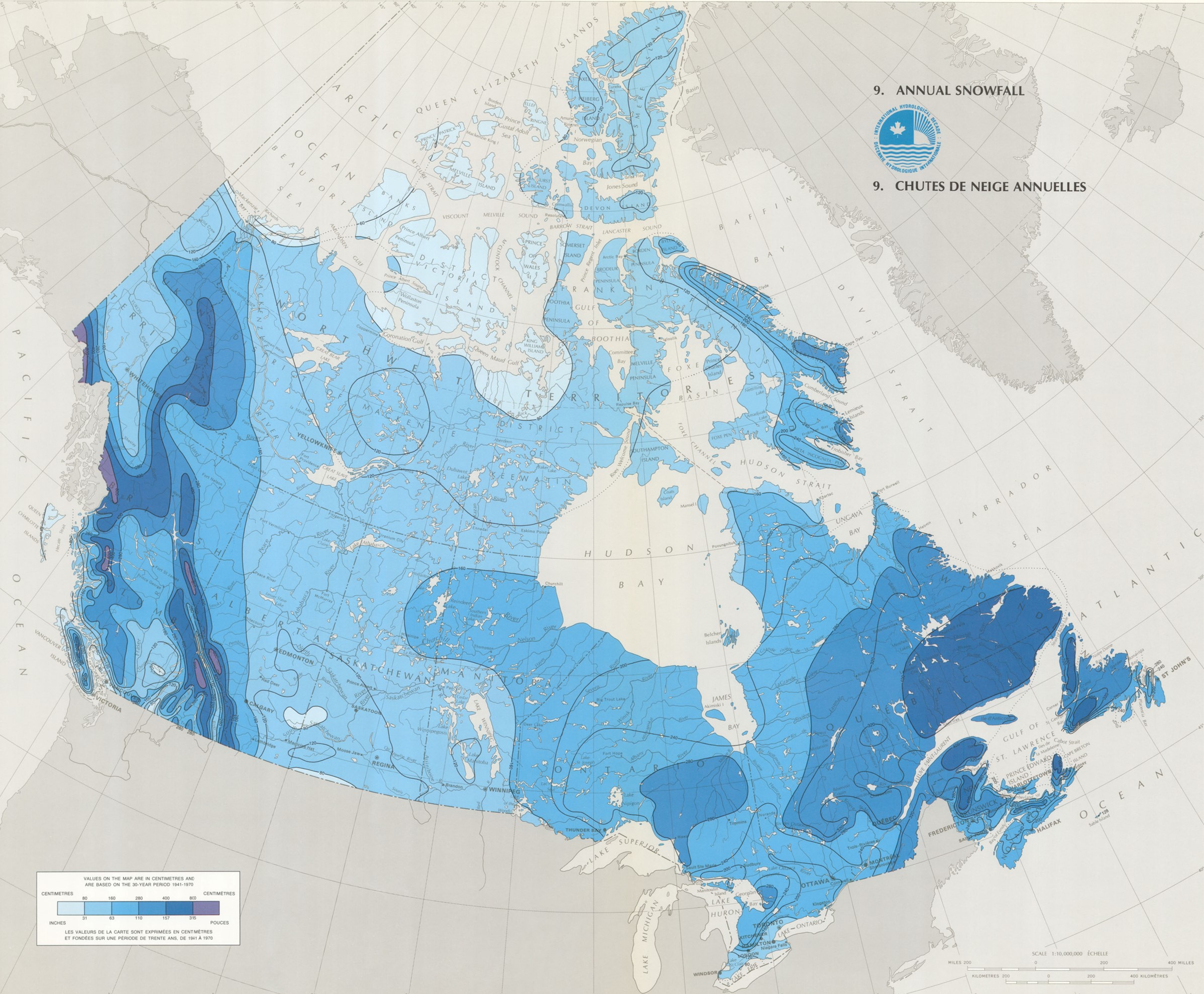
Annual snowfall amounts vary greatly across the country as depicted in this image. Notice the enhanced snowfall near moisture sources such as the oceans and inland from the Great Lakes. Similarly, zones of heavy snowfall are noticeable over higher terrain due to orographic near the Laurentian and Appalachian highlands, the Torngat Mountains of Labrador, as well as the Coast and Rocky Mountains of British Columbia.
Interestingly, relatively light snowfalls are observed in regions adjacent to the Pacific and Atlantic (such as near St John’s, NFLD, as well as coastal BC) oceans despite high annual precipitation. This is due to warmer winter temperatures causing precipitation to fall mostly as rain. Light snowfalls are also reported in the continental interior and far northern regions where there is more limited atmospheric moisture to feed into low pressure systems, limiting the amount of snow that can be generated.
Image source: Geogratis
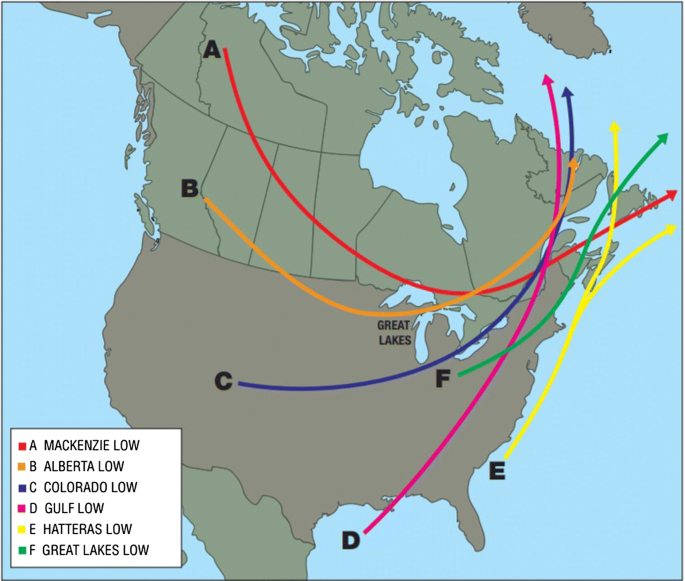
There are also certain kinds of low-pressure systems that produce snowfall more easily than others, influenced by whether or not that storm track has a reliable source of moisture to feed into the system.
Alberta Clippers and Mackenzie Lows, for example, are born in relatively cold and dry regions. Since limited moisture is available for much of their life, they produce little precipitation.
Lows passing up the eastern seaboard (Hatteras Lows/Nor’easters and Gulf lows, for example) are born in warm, humid conditions, providing lots of heat and moisture to generate large amounts of precipitation.
Image Source: SpringerLink
Overall:
Visibility forecasting in snow is also challenging for a variety of reasons:
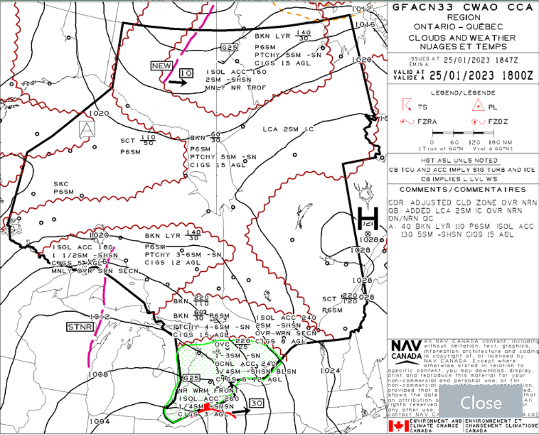
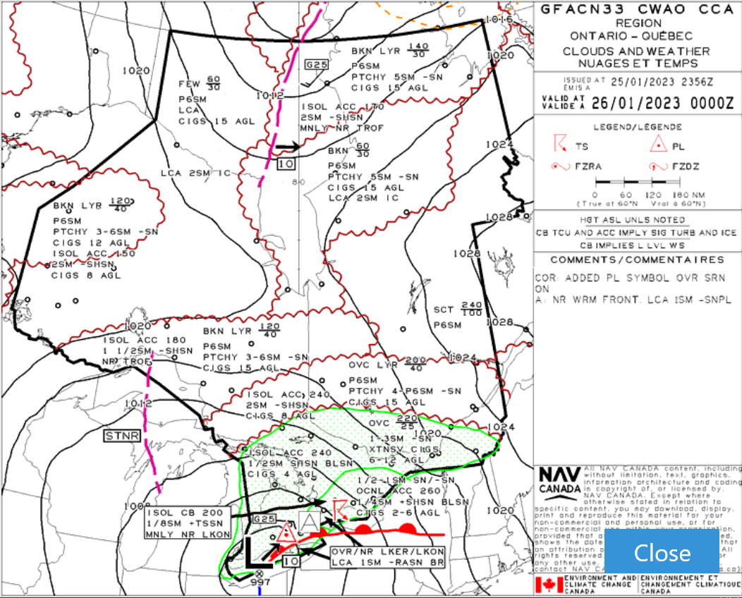
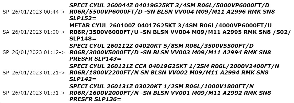
This GFA sequence depicts the evolution of a major winter storm impacting CYUL on January 25th 2023. The terminal finds itself north of a warm front in an area of continuous light snow. In addition, isolated ACC and strong winds are further deteriorating visibility due to local blowing snow. This is the GFA panel for January 25th 1800Z as the warm front approaches airport hub CYUL.
This is the GFA panel for January 26th at 0000Z when continuous snow reaches airport hub CYUL. As illustrated, an area of organized moderate to heavy snow begins to affect the terminal by 0000Z. With this airmass temperatures are sufficiently cold that no mix/liquid precipitation can occur. Thus, the snow will be drier/lighter in nature due to relatively cold temperatures (high snow ratio). As a result, visibility will tend to be worse due to finer snowflakes and snow will accumulate faster than what might be suggested by guidance models for similar snowfall rates in warmer/wetter conditions. Furthermore, lighter snow combined with gusty winds will lead to blowing snow as depicted in the GFA. This organized synoptic event last a whole 24h until the system eventually tracks east and weakens.
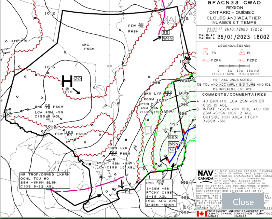
The GFA panel for January 26th at 1800Z shows how the system gradually tracks eastwards and weakens, leading to improving conditions at airport hub CYUL. Furthermore, lighter snow combined with gusty winds will lead to blowing snow as depicted in the GFA. This organized synoptic event last a whole 24h until the system eventually tracks east and weakens.
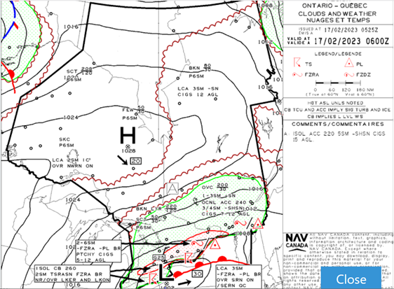
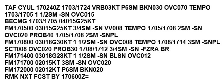
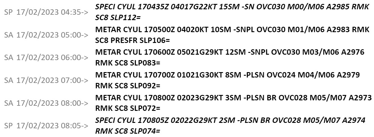
This GFA sequence is another example that illustrates a system affecting southern Quebec bringing a bag of mixed precipitation. In this case, the terminal remained just north of the area of organized freezing precipitation and reported mostly snow mixed with ice pellets. This image shows the GFA panel from February 17th 0600Z. It shows an area of freezing precipitation north of the warm front is approaching the Montreal area. As shown in the third image of the TAF section, the forecaster was already forecasting snow pellets.
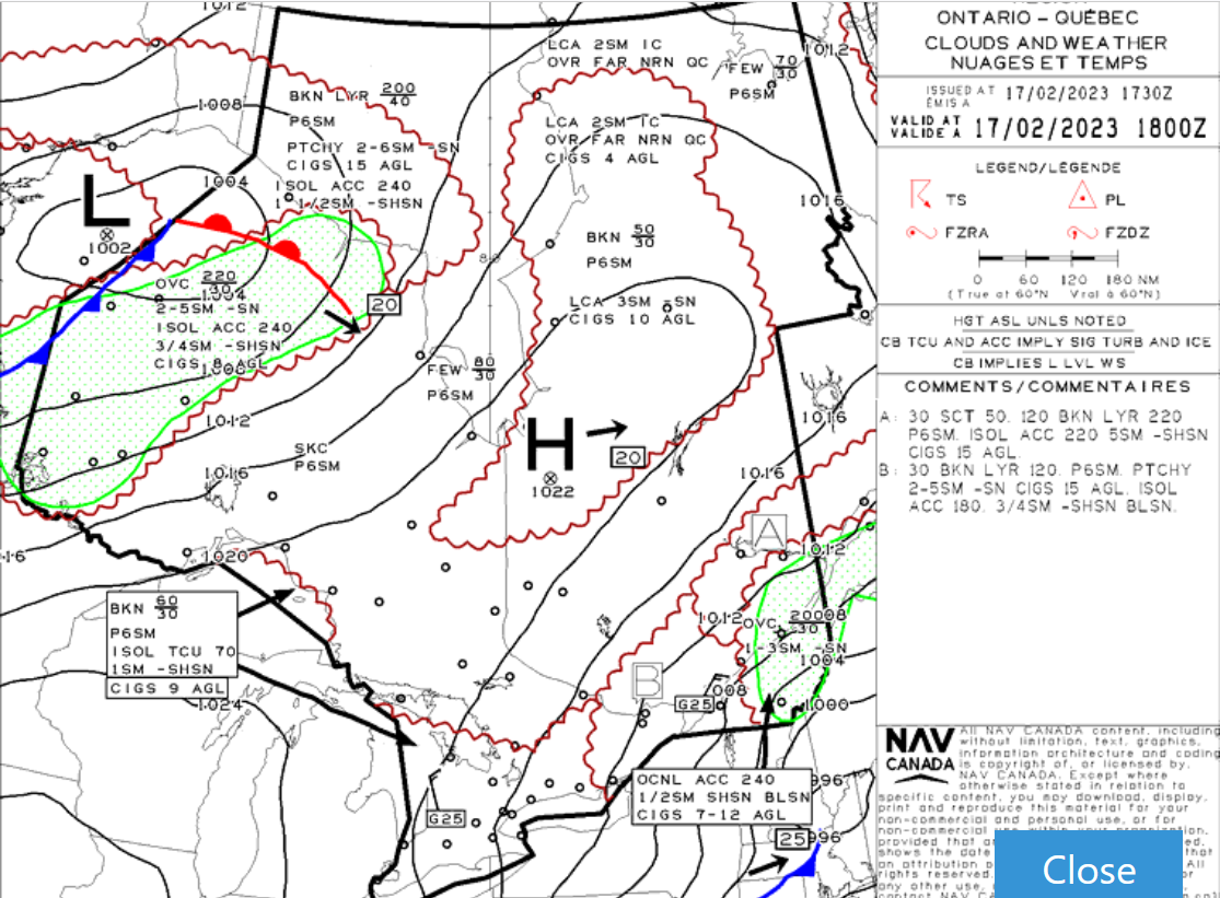
By the late morning/early afternoon, the system is on its way out with the warm front no longer providing warm air aloft. Thus, a few hours of drier snow and blowing snow were observed before the end of the event. This GFA panel on February 17th at 1800Z shows improving conditions as the low progresses eastward and a ridge of high pressure builds in from the west.
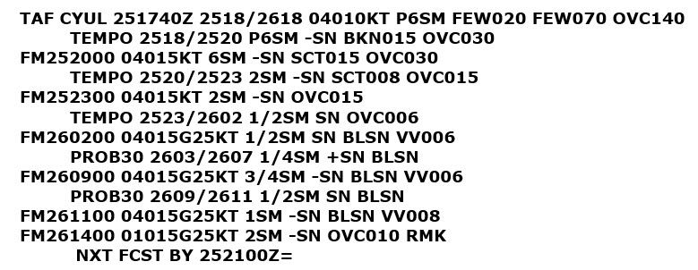
The TAF has progressively deteriorating conditions due to snowfall rates becoming moderate (≤1/2SM) and gusty winds picking up. Notice how in the TAF and the METAR the decline of visibility coincides with the onset of gusty winds causing blowing snow.
The TAF has progressively deteriorating conditions due to snowfall rates becoming moderate (≤1/2SM) and gusty winds picking up. Notice how in the TAF and the METAR the decline of visibility coincides with the onset of gusty winds causing blowing snow.
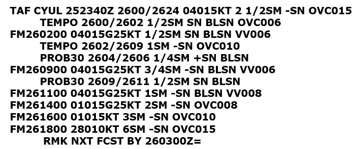
As a Colorado low approaches southern Quebec, the TAF warns of worsening conditions due to snow obstructing visibility. The visibility is significantly lower once the gusty winds kick in and snowfall rates increase. Despite this, due to the temperatures being warm and snow wet and heavy in nature (low snow ratio), no blowing snow is anticipated until next morning when the temperatures become colder. The TAF also warns about the risk of ice pellets and freezing rain. This is typical of systems coming in from the south advecting warm and moist air, particularly ahead of the warm front. This type of weather system can be challenging to forecast as small changes in the trajectory of the system will impact the precipitation type and the snow accumulations.
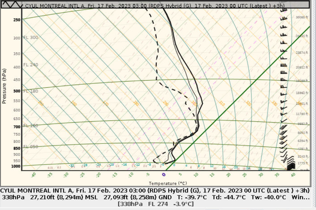
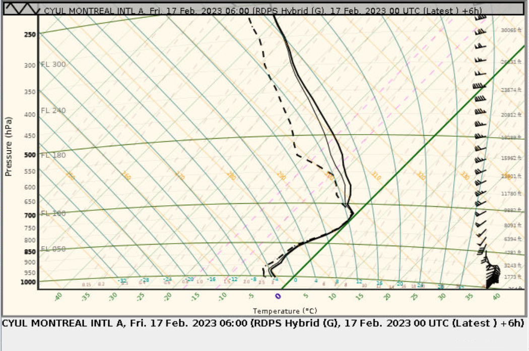
The following tephigrams illustrate the difference between profiles indicative of snow versus ice pellets. This is the tephigram valid on February 17 at 0300Z, with CYUL showing a snow profile. At 0300Z, the entire air column is sufficiently cold to produce wet and heavy snow. As the warm front approaches, an Near Freezing Layer between 5000ft and 8000ft partially melts the hydrometeor which freezes before reaching the surface. producing ice pellets instead of snow.
Image source: Environment and Climate Change Canada
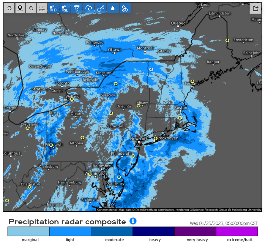
Radar composite for January 25, 2023 at 2200Z, when continuous snow begins at CYUL.
Image source: Environment and Climate Change Canada
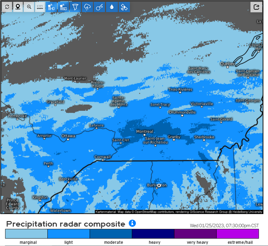
Radar composite valid at 0030Z on January 26th, when an area of moderate snow was giving below alternate conditions at CYUL.
Image source: Environment and Climate Change Canada
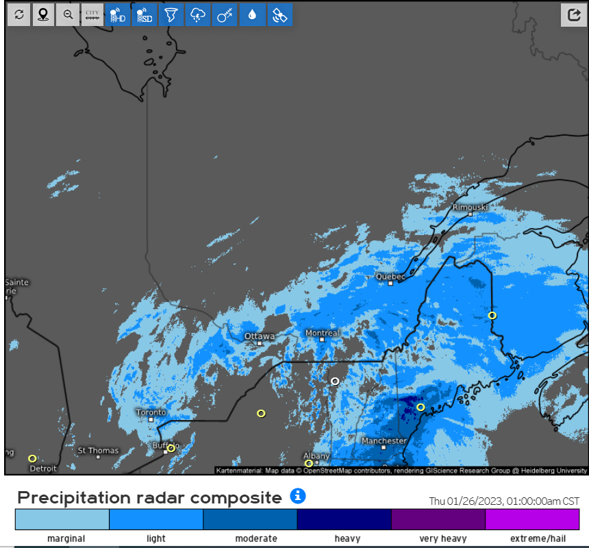
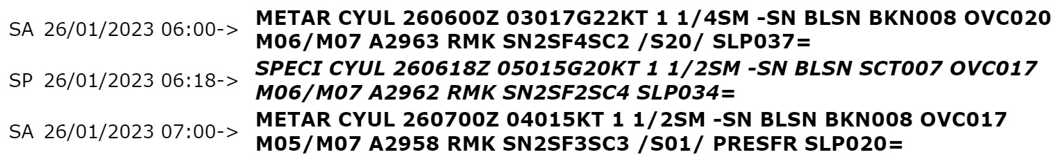
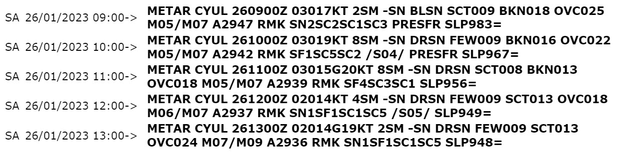
By 0100Z, mainly below alternate conditions in visibility and vertical ceilings are reported due to light to moderate snowfall and blowing snow. With temperature of about minus 10 degrees Celsius and winds gusting up to 25kt, snow with high snow ratios will easily cause blowing snow.
Shortly after conditions improve further to intermittent IFR as the system weakens. By 20Z, the event is over.
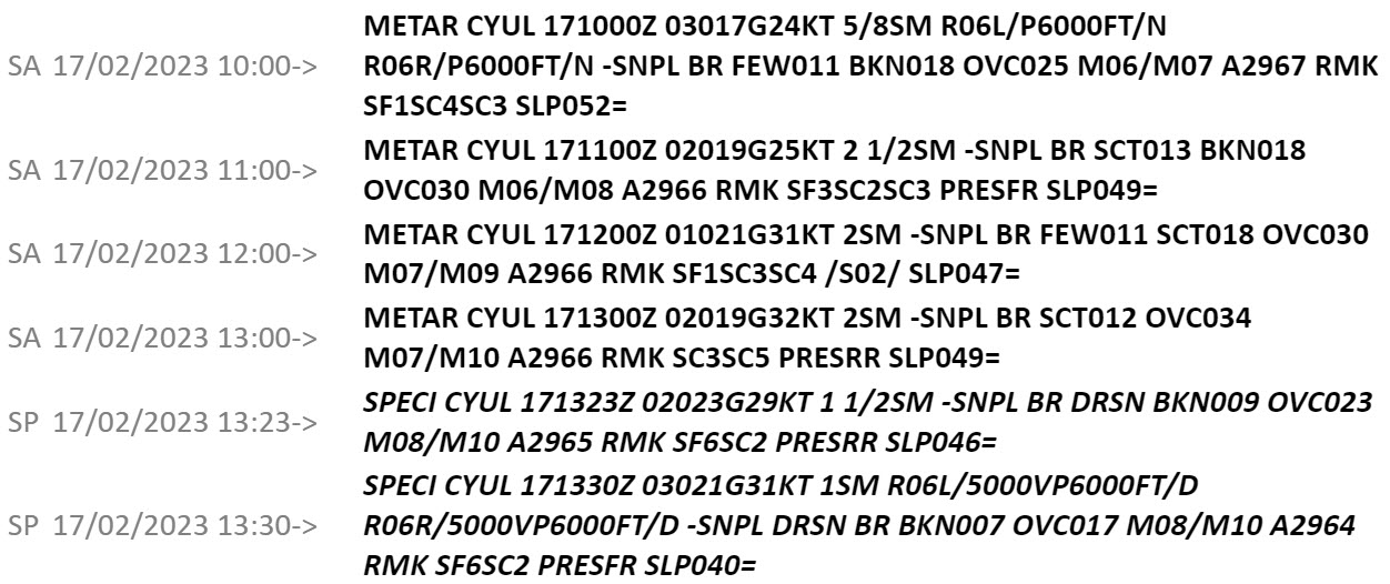
The following are METARs for the February 16-17, 2023 winter storm event. Snow mixed with snow pellets begin around 0400Z but conditions only deteriorate later than what the initial TAF had anticipated. While winds have become gusty, precipitation is too heavy/wet in nature to further reduce visibility at this point.
It is only around 1000Z that conditions truly degrade to IFR/below alternate due to snow pellets and snow.
As opposed to earlier, the station is reporting BLSN with cooler temperatures and precipitation becoming drier over time. Notice that the air column is now too cold for ice pellets to form. While the start of the event was a bit delayed, the end of the event occurs accordingly to the initial TAF with a brief period of SN and BLSN prior.
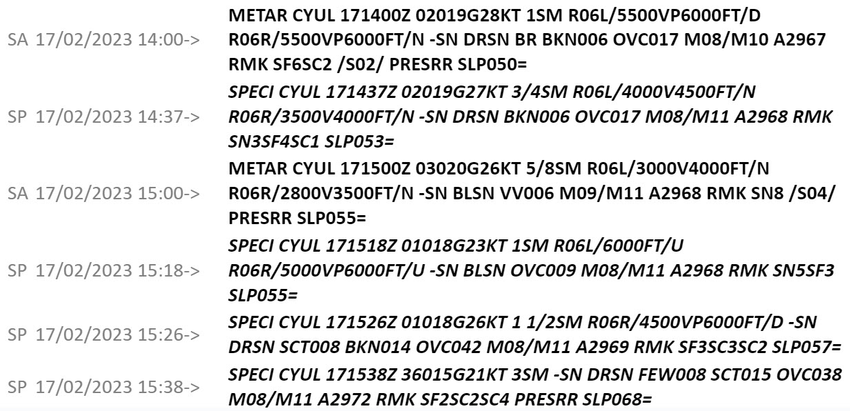
This is a CoSPA radar composite of precipitation type for the February 16-17, 2023 winter storm example provided.
Image Source: Massachusetts Institute of Technology Lincoln Laboratory
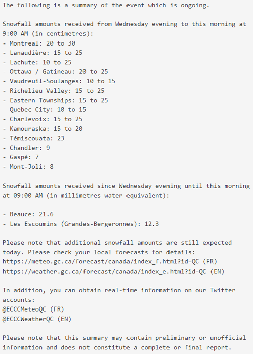
Various communications issued by the public weather offices on Twitter (now X) and on official website regarding this event. This example is Twitter (now X) content emitted by the Quebec Storm Prediction Center on January 22nd 2023 ahead of a major snow storm affecting southern Quebec beginning January 25th 2023.
Image source: Environment and Climate Change Canada
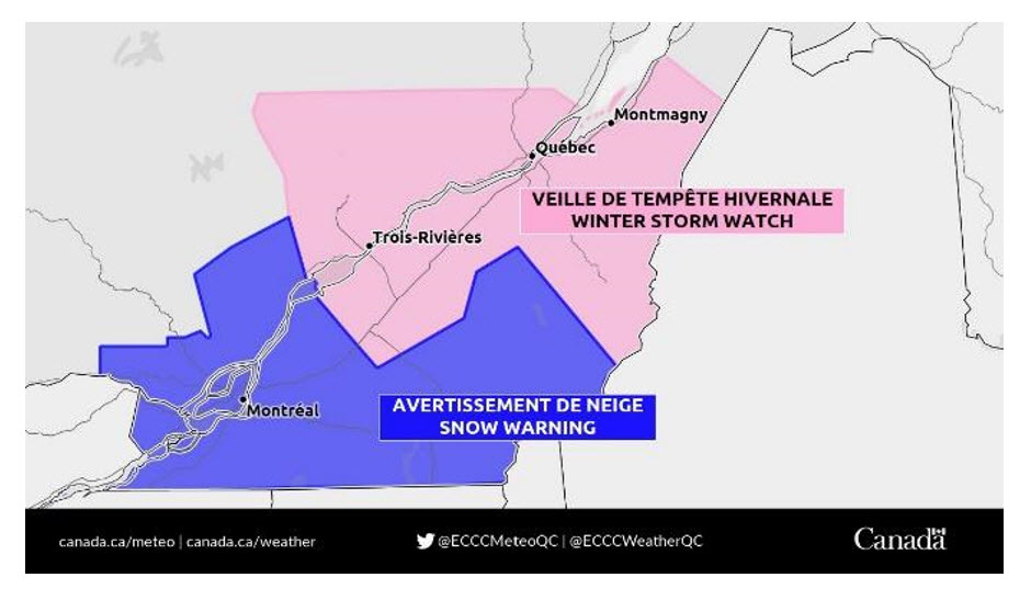
Warnings emitted by Quebec Storm Prediction Center on January 24nd 2023 ahead of a major snow storm affecting southern Quebec beginning January 25th 2023.
Image source: Environment and Climate Change Canada
Contaminated runways increasing runway occupancy time and decreasing braking action efficiency. Decreased holdover time depending on snowfall intensity, possible loss of lift depending on deicing capability of aircraft.
Snowfall events generally require increased levels of staffing to coordinate and conduct operations. Additional staffing is required to clear runways, taxiways and apron areas. Additional staffing is required to operate central de-ice facilities and large airports tend to activate operations centers to coordinate all of these operations. Snow clearing crews are generally part of the general staffing but for large events, additional crews may be required on a call out basis. With the increase in staffing required, taxiways, gates and the runways may be closed for brief or extended periods of times.
For the GTAA:
Large snowstorms
This information can then be used to assess how the forecast will impact operations by analyzing expected demand versus capacity, which helps determine start and end times, and best/worst case scenarios.
Benefits of major snowstorms is their predictability. There is usually good consensus to the timing and duration of the event, and strategic plans can be made by Operations Duty Managers for proper GDP implementation in a CDM effort with the NTMU, airport authorities, and major airlines.
High uncertainty or highly variable events are often most difficult to plan for given the complexity of snow removal operations and determining capacity constraints.
PROB30 Events
De-icing impacts departure volume especially during peak times. GTAA will institute a departure TMI (D-TMI) to stage aircraft (issued departure slot times) to minimize queuing.
Under certain conditions departures require ice-shedding run ups and if this is done on the RWY it increases the time required for departure and reduces the # of aircraft movements per hour.
Forecaster notes in HubWx are crucial to planning. Operations Duty Managers use CoSPA (winter precipitation mode), upstream stations, satellite imagery, real-time obs, and model data, to name a few, to monitor snow events. Usage varies based on an Operations Duty Manager’s knowledge and experience.
Questions that come up:
The GTAA will plan a snow removal and de-icing plan along with a departure rate which may need to be considered. If it is low, the NTMU will have to consider rates of snow fall and turn around to ensure the arrival rate will not cause gridlock. At this point they will predict a true arrival rate and should demand exceed capacity, determine a GDP rate.
There is a very big difference between TEMPO and PROB30/40: it’s where predicting the potential GDP rate and its impact on the true arrival rate become crucial, especially as these two numbers may not necessarily be the same.
It’s important to underscore the importance of understanding a CMAC forecaster’s confidence. It impacts how confident we and the users are in the forecaster.
Often when the events are temporary and sporadic a GDP will be planned at a higher rate than we can manage when it is actually snowing, as the hourly rates will hopefully even out as the evening progresses between low rates during the snow and higher rates when it is clear.
The more uncertain the forecast the more difficult the planning process is, as safety must be ensured while trying to achieve system efficiency and addressing users concerns. The users will usually push for more efficiency knowing that we will always ensure the system is safe.
Ideally a forecast would be as detailed as possible indicating what the CMAC forecaster believes is most likely to happen, if they are unsure, the second best scenario is they will provide a best case scenario and the worst case scenario. In these cases we will be as optimistic as we can be, but ensure we can ensure safety if the worst case scenario occurs.
Enroute
Regional Airports
ATC (Major Tower)
Snow affects all tower operations.
When there is snow, aircraft go to de-icing and the vast majority of those going to de-icing need an engine clearing and a run-up before take-off on the threshold, which significantly increases runway occupancy time.
The fact that snow is measured in terms of obstruction to visibility rather than the amount of precipitation per hour for our operation can be most misleading from a planning perspective.
Even once the precipitation is over, crews must return to the runways/taxiways to push the snow away from the edge so as to prevent additional contamination with the next storm. This will result in a reduced rate even after snow ends to allow for all runway and taxiway clearance to be completed.
Most often the maneuvering areas are clearer of snow than the aprons because the immediate need is to displace the snow on those areas whereas it needs to be completely cleared on the apron. This is done with trucks, which complicates and prolongs the operation and can lead to airport congestion.
For CYUL:
ATC (Regional Tower)
As a regional tower controller we are typically operating “in the moment” and forecasted snow isn’t considered until we are at work and running the operation for the day. During snow operations, however, there are some additional considerations as follows as an example of CYAM operations:
Snow is a critical safety factor in winter operations, as removal of surface contamination is essential to safe airport operations. The effect of this phenomenon on FSS operations cannot be overstated – the extra effort and attention required for winter operations is demonstrated by the annual Winter Ops Refresher Staff Memos that are posted at Flight Service Stations and FICs across the nation in September, every year. These memos often refer to Interunit Agreements and Memoranda of Understanding with external agencies, reminding Specialists that our Unit may have advisory agreements with Airport Operations at aerodromes, to warn local operators of impending snow events.
Specialists at both Advisory Sites and FICs are responsible for Weather Observation, so snow events involve increased vigilance to detect when weather conditions meet local special criteria, multiple trips outside to monitor the Ice Accretion Indicator, and trips the Synoptic yard to measure snow depth and check the snow gauge for snow fall amounts.
FIC
At Flight Information Centres, the Area of Responsibility covers a vast geographical area, demanding a more strategic view of the weather. An FIC may have agreements with various airports within our AOR for snow event alerting, but most of the unit workload increase will be issuing CRFI. At Winnipeg FIC, it was standard operating procedures to issue well over 100 CRFI per day in Winter, with double or even triple that number on a heavy snowfall day. This workload is in addition to Weather Briefing and Flight Planning for the AOR.
AAS
At FSS units providing Airport Advisory Service and Vehicle Control Service, snow events increase the workload for the Duty Specialist, depending on the intensity of snowfall, time of day and traffic flow at our Aerodrome. The mental demand for heightened situational awareness is a significant human factor, as the combination of increased vehicle access to runways under reduced visibility conditions puts additional stress on the specialist. Monitoring the speed and position of sweepers and plows by the FSS is essential, as vehicle operators must maintain vigilance on the radio while operating heavy, loud equipment under reduced visibility conditions. Extra coordination with the relevant ACC Sector is imperative, so that the Controller knows that destination runways are contaminated and occupied by slow moving vehicles – the consequences of a late handoff to FSS of an IFR Inbound can be costly (in the event of a “Go Around” because of insufficient time to evacuate vehicles from the landing runway), or even disastrous (this situation was a major factor in the PWA314 crash at Cranbrook, BC, 11 Feb 1978. This incident led directly to FSS being given Ground Control authority over vehicles on Airport Manoeuvring Areas in Canada.)
Snow requires significant coordination between controllers along with complex and critical timing, and a steep rise in additional information to give to pilots. It also has a major impact on airport capacity and therefore, in the case of a major airport, on the entire upstream system. This can have a significant impact on a terminal controller’s workload since whatever affects the airport directly affects them almost immediately. An airport’s capacity may be significantly reduced for the following reasons, among others:
CYUL Example
There are 2 parallel runways, so when it’s snowing the snow removal teams will alternate runway sweeps. Impact:
What impacts the arrival rate?
In regular parallel runway operations, we will have one runway being primarily used for departures, and one runway primarily used for arrivals.
Often, snowstorms mean low visibility and reduced braking action, resulting in aircraft taking more time to taxi off the runway and a higher ROT.
Cold weather also often results in aircraft needing to do a short run-up before taking off. If this occurs on the runway, it will increase the amount of time (and resultant spacing) needed between planes. See Barrel Icing under the Commercial Pilot tab.
Final Result
Uncertainty
SRIP – ATC must try to optimally “time” arrivals with the snow removal team to maximize the number of aircraft that can be landed safely and deliver optimal service. This requires multiple variables to be a viable option:
Tools Terminal Controllers have
Controllers and the ACC Operations Duty Manager have an indicator controlled and filled in by the tower using information provided by the airport authority that gives two times:
In either case, big airport or small, snow and winter weather mean a higher workload for controllers. Information to pass along includes:
Regional Airports
Most regional airports, for example CYHU, there is only one “main” runway (there are others but they are shorter and rarely used for our IFR traffic), snow removal requires a temporary closure of the airport.
In either case, big airport or small, snow and winter weather mean a higher workload for controllers and a greater impact on the system as a whole. Information to pass along includes:
Overall, instead of having an initial contact that lasts 5 seconds, it might last 20 seconds. Snow means lots of coordination between controllers, timing, and loads of additional information to give to pilots.
Snowfall for low-level IFR ATC can have a major impact.
If there is too much, the airport can close for an undetermined amount of time. More commonly, at airports like CYUL, one runway will close at a time for snow removal, leading to delays for landing aircraft. Regional airports tend to close for an undetermined amount of time when there is heavy snowfall. NOTAMs are published but as enroute controllers, we must be certain that the pilots are aware of the closures as the NOTAM could have been published after the aircraft was already in flight.
Snow doesn’t directly impact the high-level in most cases.
Two indirect impacts during major storms or unexpected heavy snowfall are:
Image shown on the left, when paired with the following TAF:
TAF CYZF 051140Z 0512/0612 33010KT P6SM -SN BKN020 OVC070
TEMPO 00/0506 1SM -SN SCT020 BKN070
The forecast condition indicates light snow after 00z. When considering the temperature (assume M1 and a night operation) snowfall (in terms of deicing) must be considered to be heavy and some aircraft will have limited or no de-ice abilities. This is an additional factor that must be considered for airline operation. Note- at many major airports LWE (liquid water equivalent - see commercial pilot tab) sensors will take precedence over this chart and potentially allow de-ice operations as the actual liquid water equivalency is analyzed.
Commercial airlines tend to run schedules based on best case (good weather) scenarios and snow events can cause considerable disruptions. Maintenance schedules, flight crew duty days, airport staff in general cannot maintain a normal schedule during a snow/de-ice event and the commercial schedule may need to be adjusted.
Snow at major airports is more disruptive than at a regional airport due to extended taxi times and arrival and departure initiatives that are generally in play.
Identifying snow events are generally identified 24-48hrs in advance through the use of:
TAF products that give clear indications of the expected weather are always preferred. High uncertainty forecasts that use many TEMPOs and PROBs make it difficult to make schedule adjustments (cancellations, delays).
Snow events with temperatures near zero are more difficult to deal with than ones in very cold temperatures.
Heavy snow (+SN) generally slows operations to a point where operations cannot be conducted efficiently. While the potential for +SN conditions can be clearly indicated in a TAF, an additional constraint to airlines may not be apparent to aviation forecasters- de-ice holdover times are based on the visibility, temperature and time of day and a forecast indicating light snow could in fact qualify as heavy snow depending on conditions/time of day.
Scientific research has demonstrated that the use of observed visibility in snow as the sole criteria for establishing snow intensity is not accurate enough for use with the holdover time guidelines. The evidence indicates that a visibility and temperature pair needs to be used for establishing the more accurate snowfall intensity required for use with the holdover time guidelines. (see TC TP14151EOpen a new window)
As snow accumulates, runways can become contaminated, and crosswinds become critical factors to consider.
At Regional Airports
With reduced volume, full resources can be brought to bear on individual flights. Deice delays may be reduced as this can be done at the gate, runway crews can time aircraft arrival and departures providing targeted runway clearing- sometimes a regional airport can function more efficiently than a major airport, even though resources may not be as robust.
Enroute
Three main threats with snow:
Pilots will start making their plan of action once in cruise.
Pilots use visibility to assess snowfall intensity. We can look at the radar to check if a shower is approaching, but the visibility is how we judge snowfall intensity. With that in mind, let’s talk about threats to the operation during a snowstorm and how we mitigate those threats.
In a Forecast (a TAF)
Use of Prob/Tempo regarding snow/ceiling/vis changes how much fuel is loaded for additional attempts to land.
Ceiling and visibilities in snow tend to be better than reported while on approach.
The temperature of the runway is key to determining the runway condition which is rarely available to flight crew.
Takeoff performance
De-Icing Operations
De-icing an aircraft is done in two steps:
Rate of snow is considered to use the snowfall intensity chart correctly for de-icing operations. The Day/Night changes are very important to recognize as at night visibility appears to be improved and you can underestimate the snowfall rate if not careful.
At most of our major airports, we now have a “Liquid Water Equivalent System” (LWES). It is an automated weather measurement system that determines the Liquid Water Equivalent (LWE) rate in conditions of frozen or freezing precipitation.
If we are at an airport where there are no LWES or the LWES is U/S, we must use the METAR to determine the HOT, which can be more restrictive.
Side note to de-icing or anti-icing fluid can infiltrate in the bleed air source of the aircraft might lead to a fume or smoke event in the aircraft. It has happened after takeoff, during the taxi-in as well. We don’t have a choice to take this threat seriously, if it happens, it could trigger an emergency.
Barrel Icing
The main reason why we conduct an engine runup before takeoff. The A319/A320/A321 are more prone to this type of icing.
Prolonged taxiing in significant snow events can lower the heat efficiency of the engine anti-ice system. The engine anti-ice system is meant to be evaporative. Due to that reduced efficiency, the water doesn’t evaporate, but instead melts, moves aft into the unprotected nacelle liner, and eventually refreezes.
Over time, an ice plate forms in the engine nacelle inlet. The ice plate can detach and be ingested in the core of the engine. Also, the fan blades flex forward with takeoff thrust, and by moving forward, it can start to scrape that ice plate, damaging the fan blade tips.
Overall
Looking at streamers on RADAR off the great lakes to determine the best time to go to the de-ice bay.
During snowfall, icing tends to not be a factor for jets. Turbo Props will get stuck with a little bit of leading edge impact ice that may not be removed via de-ice boots generally.
Snow combined with a crosswind/quartering headwind on final approach and landing can cause some pretty good illusions just prior to and during touchdown. Pilots will often choose to leave the landing lights off during landings of this type to see the runway rather than the snow, which may be disorienting - this is pilot preference but similar to a driver avoiding using high beams in heavy snowfall while on the road.
Rate of snow is considered to use the snowfall intensity chart correctly for de-icing operations. The Day/Night changes are very important to recognize as at night visibility appears to be improved and you can underestimate the snowfall rate if not careful.
Caution and extra time (fuel) is loaded to account for intermittent delays due to snow clearing of the runway, traffic backup possible diversions due to runway condition.
Regional Airports
For departure at uncontrolled airports, the controlling visibility is the lowest of the ground visibility (METAR), any reported RVR, or pilot visibility. We are regulated by all the available visibilities. Here’s two examples where we could land but can’t takeoff unless there is an improvement:
At major airports, runways are typically long enough that the landing distance will not be an issue during the landing performance calculation.
Crosswinds
One likely main issue is a strong crosswind condition, when observed.
The greatest threat with a crosswind on a slippery runway is losing the directional control of the aircraft.
Holding
Typically jets can exit airborne icing situation by climbing, descending, or accelerating. This includes flying through supercooled large water droplets and short-lived flight through freezing precipitation.
Icing strongly depends on atmospheric conditions. On the prairies in winter anecdotally this hasn’t been an issue.
If you are near a large body of water and the water hasn’t frozen over yet, falling snow can be a hint of how severe the icing in the tops of the low-level clouds will be.
METAR and TAF reports can be hard to interpret and make it challenging for VFR pilots to predict how the snow will affect them. Interpretive weather briefings from FIC specialists can add clarity to flight planning through a snow event.
A forecast of light snow will often include a visibility greater than VFR, but still lower than the comfort level of many GA pilots. Snowflake size, amount, volume and frequency can change rapidly and can quickly affect the visibility in flight.
At major airports, snow removal is efficient, but priority is given to commercial and IFR aircraft, so significant delays are to be expected for VFR aircraft.
Conditions of heavy snow will prevent VFR flights, so this is only an issue during light snow that requires continual clearing or shortly after a heavy storm has occurred – VFR GA anticipate long delays immediately following storm.
Snow at regional airports as well as uncontrolled aerodromes can have varying degrees of ground operations impact. In all cases, delays are to be expected and a certain element of risk is present. Snow creates many challenges for GA pilots, especially at less busy airports and they must consider all of the variables and scenarios presented when making a decision on how to operate their flight.
Moderate to heavy snowfall have the greatest impacts on the following:
De-icing
Contaminated runway and taxiways
Many small GA aircraft can operate safely with some snow on the taxiway and runway surfaces. However it is often not recommended because there are many factors to take into account.
With light snow on surfaces, wind will create blowing snow which can greatly reduce visibility during taxi, takeoff and landing. Snow can also blow sideways across surfaces, creating an illusion to pilots that the ground is moving, even while the aircraft is stationary.
The depth of snow on the ground is an important factor.
Snow clearing operations
Snow removal operations vary greatly at regional airports and uncontrolled aerodromes.
When planning a flight, or in flight, pilots can’t rely on a runway to be cleared for them.
Some snow removal operations will just plow the current snow and leave a layer of compact snow on the runway.
Some operators only remove snow from certain taxiways or runways, leaving the others untouched. Some will clear the runway during light snow while others will wait until no more snow falls and none is in the forecast.
Specific to low wing GA airplanes, snow removal operations at regional airports often leave snow banks on the edges of runways and taxiways, creating an extra hazard for these aircraft. In extreme cases, this can even affect high wing GA aircraft.
Snow presents an icing risk in flight, however visibility is the main factor to consider for VFR GA pilots.
The level of snow required to create a meaningful icing risk usually coincides with the visibility being below VFR conditions making the risk for moderate to severe icing relatively low as pilots shouldn’t be flying in those conditions in the first place.
However, when light snow is present with a high moisture content, in temperatures close to freezing (+5 to -5 degrees), there is a risk of light icing.
Pilots are cautioned against the risks associated with flying through snow in these conditions. All snow comes with a risk of reduced visibility. A pilot’s experience must back up the decision to fly with confidence in a potential visibility of 3-6SM. Pilots must be prepared for conditions to be worse than forecasted and if outside of their comfort zone, or legal limits, they must have a backup plan and execute it promptly.