METAR Code
N/A
Weather Symbol

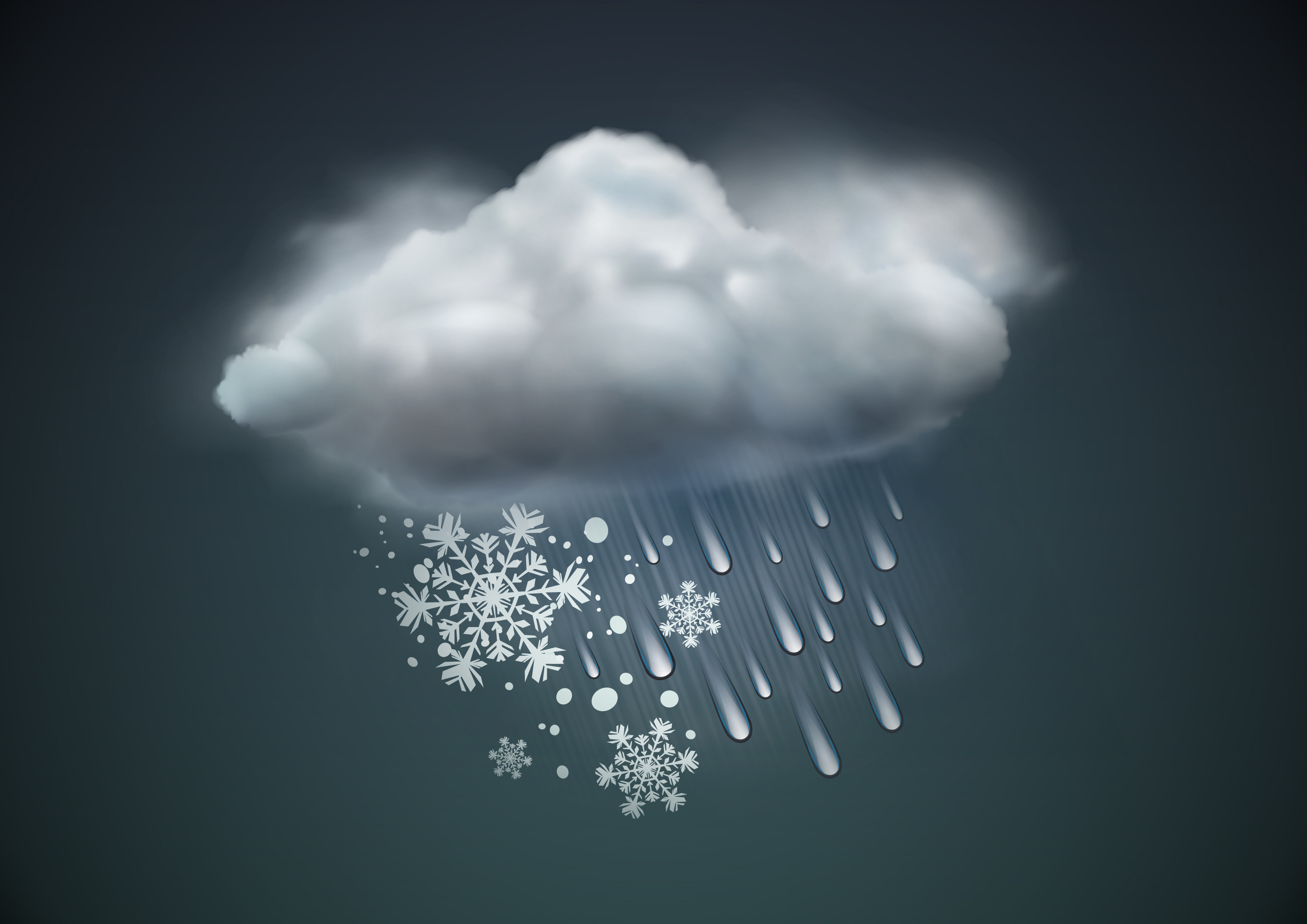
High precipitation rates, and especially sporadic high precipitation rates, can cause variable accumulation of precipitation and related ice accretion across an airfield and on important surfaces, as well as reduced/suddenly reduced visibility. High precipitation rates can impact maneuverability for all types of transportation.
A measure of how much precipitation will fall over a period of time. It is usually expressed as depth of precipitation per area per time, such as millimeters per square meter, per hour for rain, or centimeters per square meter, per hour for snow (mm/m2h or cm/m2h).
Associated terms coming soon:
Dewpoint, lake effect, low-pressure system, orographic lift, and upslope flow are all terms associated with precipitation rate that will be coming soon to the Aviation Meteorology Reference.
In order to start considering a precipitation rate, one must first have a process to generate precipitation. Whether it be a low-pressure system, convective showers, orographic lift induced precipitation, or any other method, one must have some sort of precipitation generated before rate can be considered.
Precipitation rate is highly impacted by the process that is generating the precipitation itself.
While long lasting systems with low precipitation rates can be impactful, it is particularly disruptive when high precipitation rate events persist for a long time over a single location. Events like lake effect snow squalls, atmospheric rivers, or stationary thunderstorms can cause enormous accumulation and possible flooding.
Image source: Royal Meteorological SocietyOpen a new window
While precipitation rate measures the depth of precipitation expected to accumulate in an area over a specific time period, this information is not always straightforward to measure. When considering rain, rain showers, and freezing drizzle, this is much easier to measure with on-site instruments. However, when considering snow, flurries, snow grains, ice pellets as well as drizzle/freezing drizzle, fall rate becomes much harder to measure, due to the light and blowing/bouncing nature of frozen precipitation, exacerbated by wind and/or turbulence affecting fall rate. More factors must be assessed in order to precisely determine the actual depth of frozen precipitation expected to reach the ground.
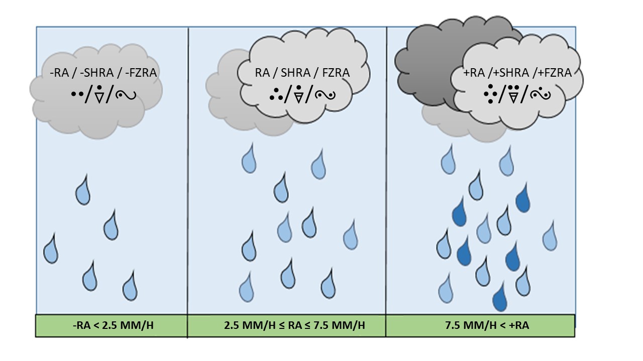
Most liquid precipitation types (rain, rain showers, freezing rain) use precipitation rate to determine the intensity (-/ /+) that is noted in METAR/SPECI.
Liquid precipitation is also frequently accompanied by mist at the surface, so while precipitation intensity indicates how much liquid is falling per hour, it does not always have a direct link to the associated visibility. Additionally, a high precipitation rate will more quickly alter the condition of critical surfaces, rendering them wet, contaminated, etc.
This image is a simplified depiction of rainfall rate as noted in MANOBS Chapter 6.
Image source: Environment and Climate Change Canada
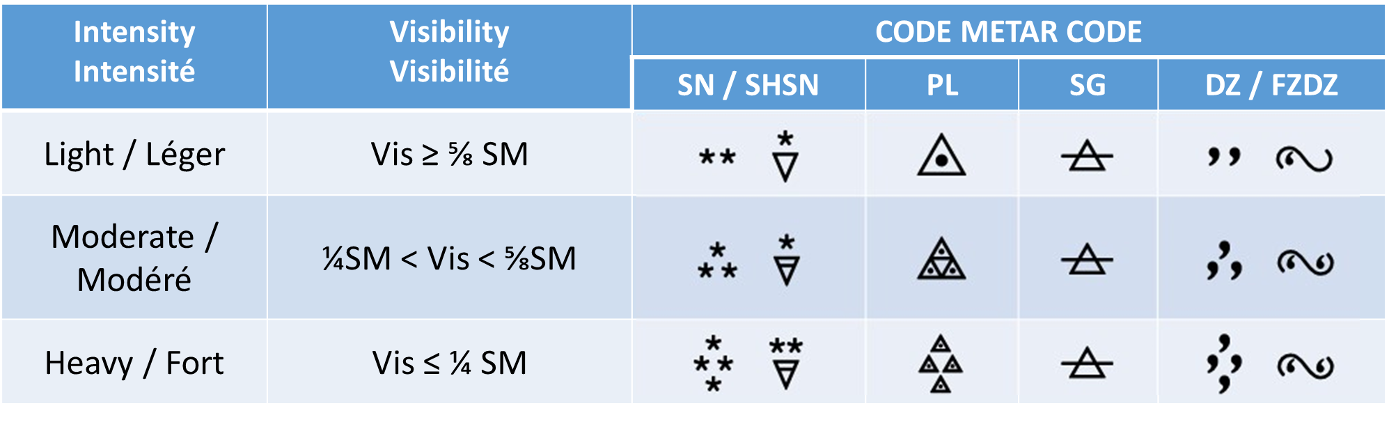
For frozen precipitation however, as well as drizzle and freezing drizzle, it is the visibility that is used to determine the precipitation intensity, as opposed to the precipitation rate itself. Since one must consider the snow-to-liquid ratio (SLR, discussed further in the Snow term) before the snowfall rate can be properly assessed, the readily observable visibility is used to determine intensity.
This image is of frozen precipitation and drizzle/freezing drizzle intensities and symbols, as defined in MANOBS (Manual of Surface Weather Observations Standards) Chapter 6.
Despite snowfall intensity and snow to liquid ratios, frozen precipitation accumulation depends on factors such as melting which takes into consideration the temperature of the air and the underlying surface (ex. runway) and any treatments that may have been applied to it. A treated runway, for example, might be experiencing a snowfall rate of 4cm/hr, while only 1-2cm is able to accumulate due to the chemical treatment of the tarmac.
Moderate freezing rain occurs infrequently and typically briefly in Canada, and heavy freezing rain is exceedingly rare. Light freezing rain, with high visibility is most frequently observed. Heavier rates tend not to last, since associated downdrafts (air being pulled down with precipitation as it falls) are often from the warm air aloft, which raises temperatures at the surface.
Image source: Environment and Climate Change Canada