METAR Code
N/A
Weather Symbol
Significant wind shift: As a cold front passes, winds shift from a generally southern direction to a generally western configuration. If the front is strong, this shift may be sharp and sudden.
Strong winds: Cold fronts tend to be preceded by low-level jets. This means winds at the surface around a cold front can be moderate and gusty depending on the depth of the low centre, which can cause turbulence due to the change in wind speed and direction associated with the front.
Convection: The warm and humid air mass ahead of the cold front along with the lift given by the cold front triggers convective weather. In the summer, this can generate rain showers and thunderstorms along the cold front. With a particularly strong front providing surface wind shear, this can yield severe thunderstorms that produce hail, downbursts, and tornadoes. In the wintertime, this zone of increased convection can produce snow squalls with whiteout conditions.
Flash freeze: The temperature gradient across a strong cold front can be quite large, and once the cold front passes temperatures can drop suddenly. If precipitation ahead of the cold front was warm and enough precipitation fell and temperatures drop quickly behind it, all the accumulated precipitation on the ground can freeze rapidly causing very slippery surfaces.
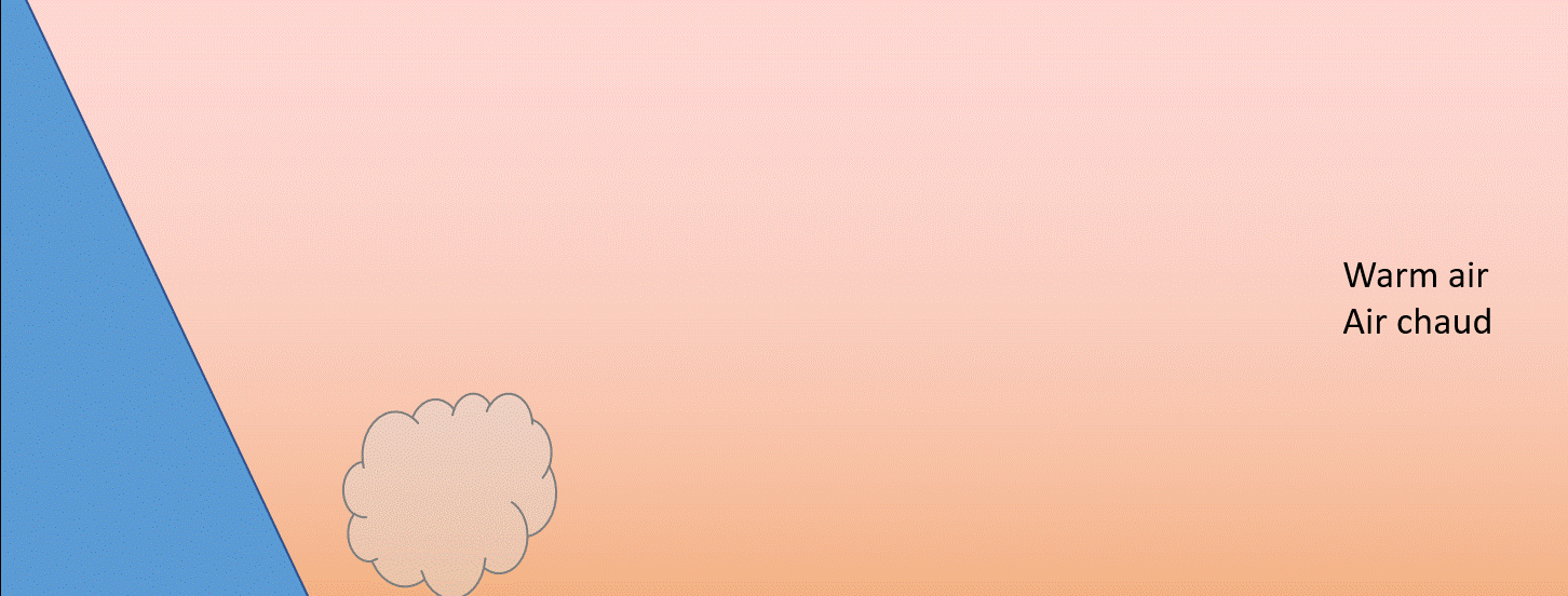
A transition zone where a cold air mass advances and replaces a warm air mass.
Associated terms coming soon:
Dewpoint and low-pressure system are terms associated with a cold front and will be coming soon to the Aviation Meteorology Reference.
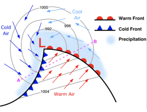
Cold fronts form as cold, dry and dense air rotates cyclonically (counter-clockwise) around a low pressure system as it develops. The circulation around the low moves the old air in typically from the north. It meets the warm, moist air being brought in from the south and displaces the warm air as it is much denser.
The boundary where the cold air mass is moving in and replacing the warm air delineates the cold front. As the cold, dense air undercuts the warm air, the warm air is forced to rise, at which point it cools and condenses, creating clouds and precipitation which are often convective.
This image shows the different air masses and their circulation around a low-pressure center. The cold air wraps around the back side of the low. The cold front, as shown, delineates the boundary between the advancing cold air and the warm air ahead of it.
Image Source: Penn State Department of Meteorology and Atmospheric ScienceOpen a new window
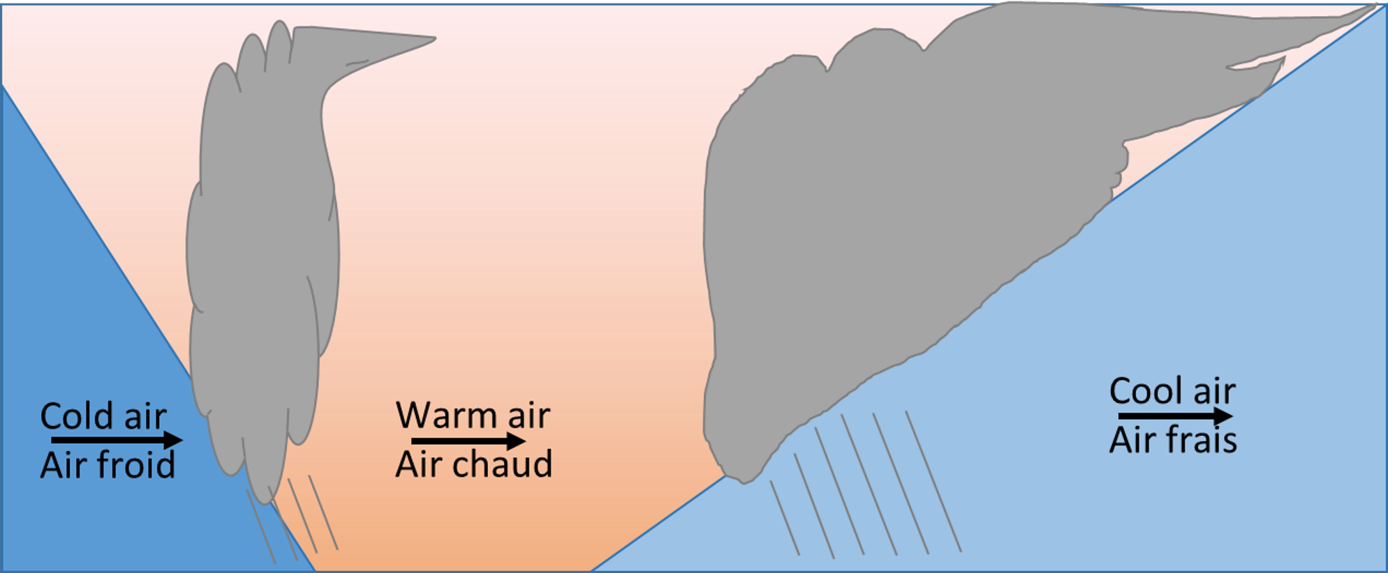
This animation depicts the advancing cold air and winds associated with a cold front. As the cold air surges forward, it displaces the warm air in advance of the cold front upwards causing clouds and precipitation to form. The leading boundary where the winds shift and the temperatures begin to decrease delineates the cold front.
A frontal zone is not a perfectly straight wall; however, a cold frontal boundary is rather steep in comparison to a warm front. Because of how steep it is, the forcing caused by the cold air undercutting the warm air upward creates more convective type clouds as opposed to more stratiform clouds created by warm fronts. Depending on the temperature profile, precipitation falling ahead of a cold front as rain can quickly change to snow with the passage of a cold front, and the temperature drop can often cause icy conditions at the surface.
The wind shift associated with a cold front is usually quite drastic, changing from a southerly wind to a westerly-northwesterly wind over a short period of time. This can cause a great deal of turbulence and wind shear. As the cold air surges forward, strong wind gusts are also common with the passage of the cold front.
Image Source: Environment and Climate Change Canada
The active weather associated with cold fronts is often short-lived. But do not let that fool you; since its lifting capabilities are so strong, the weather – while short-lived - can be quite severe in nature (such as thunderstorms or snow squalls). Quite often, the air behind a cold front remains unstable well after the passage of a cold front. This leads to gusty winds as well as remnant precipitation that is driven by the cold air aloft associated with the passage of a cold front.
This image is an idealized side view of a low-pressure system between the fronts, showing cumuliform clouds building on the warm side of the cold front as the cold air surges forward.
Image Source: Environment and Climate Change Canada
Dissipation
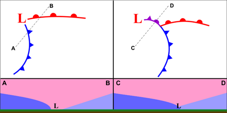
As a low-pressure system matures it enters what is known as the occluded phase. The center of the low begins to lag behind the propagating frontal boundaries. The cold front typically moves a lot faster than the warm front and “catches up” to the warm front as the cold air surges ahead and spreads outward. The cold front slowly loses its energy and the boundary between the warm sector and cold sector moderates. This is depicted by the purple “occluded front” on the second panel. Instead of warm air overriding retreating cool surface air (warm front, cross-section 1), an occluded front (cross section 2) results in a boundary that is instead defined by advancing “cold air” and retreating “cool air”. This process will continue until the dissipation of the low altogether.
Duration
Cold fronts generally last as long as a low pressure system is in the development and maturing phases, which can be several hours or up to a few days depending on the strength of the cyclone.
Image Source: Penn State Department of Meteorology and Atmospheric ScienceOpen a new window
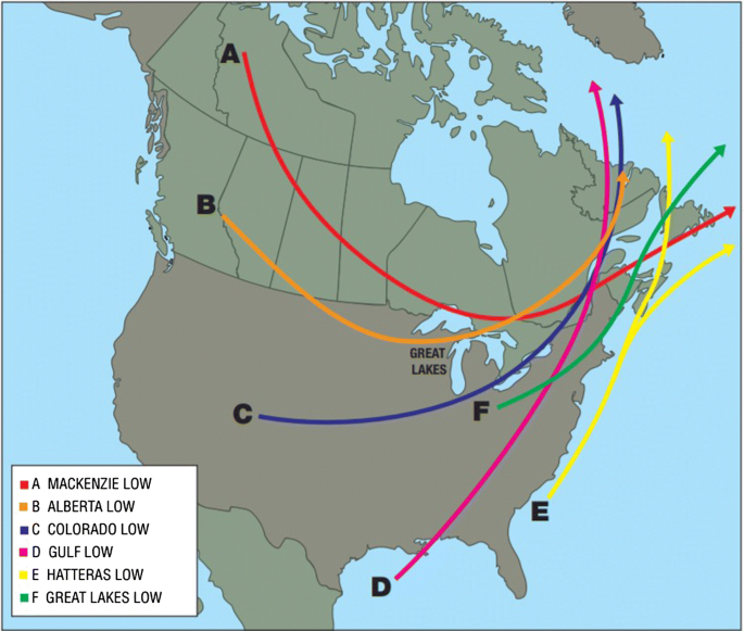
This graphic depicts the typical low cyclogenesis and their typical tracks across North America. Low pressure systems will retain similar characteristics based on their origin as well as the season, which will in turn affect the behaviour and associated weather that develops due to the cold front associated with the low.
The intensity of cold fronts and their associated weather are in large part connected to multiple different atmospheric processes. The most important to mention is seasonality. Shoulder seasons (fall/early winter and late winter/early spring) often bring the most intense storms across the country, whereas the summer months bring the most intense convection/thunderstorms associated with a cold front.
Image Source: SpringerLinkOpen a new window
The biggest forecasting challenge with cold fronts is perhaps in determining its strength and therefore pinpointing in advance how severe the associated weather may be.
Another forecasting challenge associated with cold fronts is its exact position when it’s a weaker frontal system. There are several elements that change across a front (temperature, humidity, wind direction), and if these don’t line up, which is often the case with weaker systems, it can be difficult to pinpoint exactly where your cold front lies.
The timing of a cold front can be challenging to forecast as small changes in the speed and direction of the air masses can change its arrival. This in turn can affect the surface temperature forecast and therefore precipitation phase changes, the strength of the winds associated with the front as well as the timing of the wind shift associated with the approaching front.
Precipitation typing can pose challenges as well, especially in the shoulder seasons (fall and spring) when surface temperatures are hovering around the freezing mark. The exact timing of the transition between rain and snow can be difficult and depends on a variety of factors. While forecasters can observe the shape of the frontal surface by way of upper air soundings and tephigrams, the observation network density is not high enough in spare or time to get real time data.
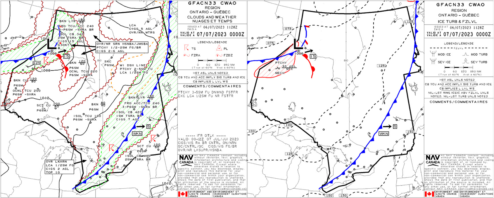
The GFA cloud and weather panels valid at 1800Z on July 6th and 0000Z on July 7th, 2023, respectively, show the progression of a cold front extending all the way from Ungava Bay in far northern Quebec to the Ontario/Michigan border. This particular front is not especially powerful, seen in part from the generally weak pressure pattern defining its location. That being said, both convective showers and isolated thunderstorms are supported along its length.
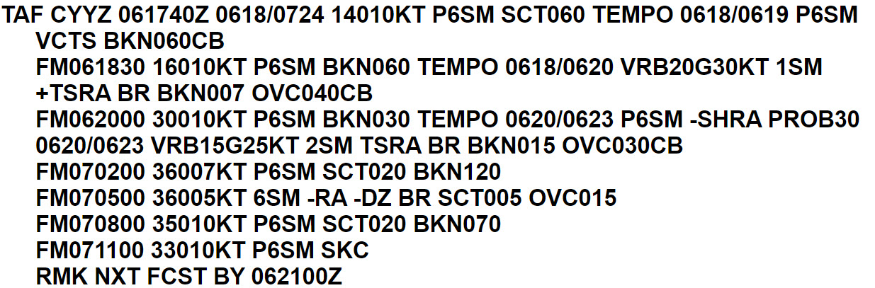
The TAF for CYYZ valid from 1800Z July 6 until 2400Z July 7 captures the forecast frontal passage. Ahead of the front are southeasterly winds, and a high likelihood that thunderstorms will impact the terminal area (within the bedposts/fixes) until 1830Z, as represented by VCTS. The forecaster has assessed that there exists enough atmospheric instability and moisture to produce convective showers and a risk of thunderstorms near the terminal from 1830Z until 2300Z the 6th. While there are distinct wind shifts in the TAF (at 2000Z and 0200Z), the wind strength is quite weak. This is representative of a weak cold front, and the weak pressure gradient seen in the isobaric pattern in the GFA panels. Looking at the GFA, the first instance of thunderstorms captured in TEMPO was associated with warm sector convection and a weak wind shift to 300 degrees true. The second instance, however, captured in the PROB30 represents the true cold front passage, with the corresponding wind shift to 360 degrees true. Behind it, an improving trend in weather conditions is forecast.
These atmospheric profiles taken from the RDPS model at 3hr intervals between July 6th at 1500Z and July 7th at 0900Z captures the forecast atmospheric instability ahead of the cold front, and the changes in weather behind it. Ahead of the front, surface winds are south to southeasterly, and the air is relatively humid and unstable throughout the column. Surface dewpoints are also close to 22C. With the frontal passage comes a gradual wind shift to the northwest at the surface, a much drier and more stable vertical structure, and a drop in surface dewpoints to 16C by 0900Z on July 7th.
Image Source: Pivotal Weather
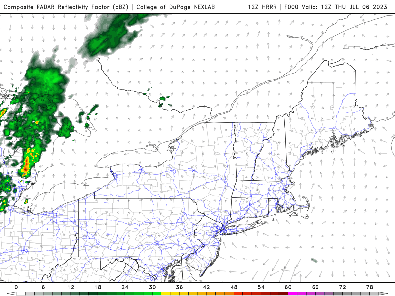
The July 6th 1200Z HRRR simulated radar reflectivity forecast captures the predicted movement of the cold front across southwestern Quebec and southern Ontario throughout the day on the 6th and into July 7th. Winds ahead of the front, as shown in the atmospheric profiles and TAF, are forecast to be southeasterly to southwesterly, with west-northwesterlies expected on its backside. While not very defined through southern Ontario, the frontal boundary gradually makes its way across the province.
Image Source: College of DuPage
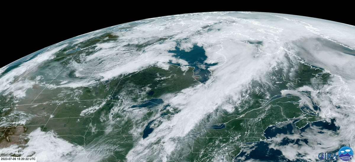
Visible satellite imagery captures the cold front as it extends from far northern Quebec across into southern Ontario. Embedded convective clouds along the front as well as ahead of it can be seen, especially closer to sunset when the shadows from cumulonimbus clouds are cast east of the storms.
Image Source: CIRA
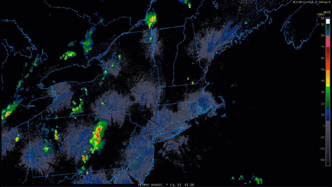
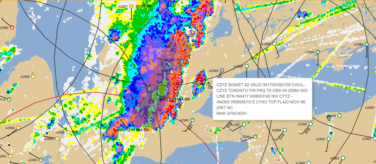
The convective showers along the cold front can be seen here moving across southern Ontario and western Quebec. Radar echoes show the majority of the precipitation to be collocated with the frontal boundary, though patchy thunderstorms exist ahead of the front due to other present triggers in an unstable atmosphere.
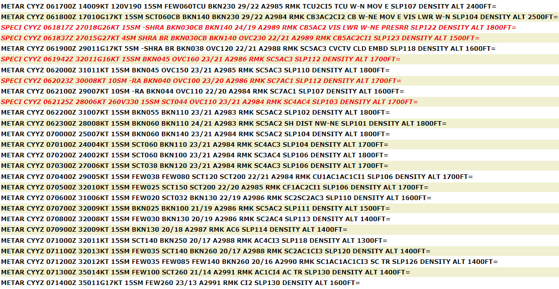
Observations in CYYZ show southeasterly to southerly winds, followed by a wind shift to 270 degrees true at 1817Z. Note how the winds remain weak after the frontal passage, with the gusts at 1817Z and 1837Z a result of thunderstorms in the vicinity. These weaker winds are one of the signs of a weaker frontal boundary – another being the more subtle and gradual change in dewpoint temperatures at the surface. Winds remained northwesterly and dewpoints dropped to 13C by 1400Z the next day, along with clearing conditions as forecast by the TAF.
Image Source: OGIMET
A cold front brings with it risks of convective activity, precipitation, possibly significant changes in wind speed and direction with height, and potential low ceiling and visibility conditions, among others. Each of these conditions present a hazard to aviation such as loss of lift/turbulence, reduced braking action, low-level wind shear, and poor visibility, respectively.
Thunderstorms are often associated with cold fronts so it is important to be aware of any thunderstorm, lighting risks to the airport as it significantly affects ground operations at the airport including the suspension of aircraft fueling, ground handling, construction projects, airfield maintenance and more.
It is essentially a ground stop unless aircraft can safely taxi and arrive and depart the runways, usually gating and pushbacks of aircraft are suspended when we are in Red Alert (high likelihood of a lightning strike).
We benefit from knowing the anticipated time of the weather event, its duration and severity.
Hubs are also likely to have a lightning monitor system.
Operations Duty Managers
ATC (Major and Regional Towers)
Thunderstorms along cold fronts are fun to watch from the control tower.
Cold fronts share the same seasonal variation as warm fronts, but the effects are more intense due to the greater threat of convective cloud and associated severe weather, particularly in summer, as well as the much higher speed of advance of a cold front. Specialists at sites that have weather observation responsibilities must be on the lookout during a Cold Frontal passage during the shoulder seasons to ensure that wet/damp conditions aren’t becoming ice/frost conditions. This not only effects aircraft but also requires notification of airport maintenance crews to begin mitigation operations.
FIC
When presenting information in a Weather Briefing, Synoptic Features such as a Cold Front are referred to initially to explain the strategic view of weather effects. Once the Briefing moves into detail around Departure Point, Enroute Track and Destination Weather at ETA, a Specialist will touch on actual and forecast local conditions, using the Synoptic feature to explain the source of these anticipated conditions. This will influence the Pilot’s choices in whether or not they go, what route and altitude they will take enroute, how much fuel they will need to perform the flight safely – this alone might cancel the flight, if the prevailing wind aloft is unfavorable, as the required fuel burn may exceed the amount of gas the airplane can carry.
The type of Synoptic feature informs the general conditions, subject to seasonal and diurnal effects, that can be expected. This is where the Flight Service Specialist working in a FIC really earns their pay, using their knowledge of meteorology in conjunction with their expertise in the unique factors contained in their FIC’s Area of Responsibility. Due to the dynamic nature of the aviation environment, no two briefings will be exactly the same.
AAS
Advisory specialists will monitor the approach of a cold front by watching for the Convective builds that often lead an advancing Cold Front, in concert with watching the weather radar and maintaining a weather watch on sites upstream. Specialists might also check the GFAs and contact the FIC for more information if required. Frontal passage is accompanied by a wind shift towards the north/northwest and a trend to becoming more gusty, as well as a rapid decrease in temperature and a rise in pressure.
Cold fronts can yield conditions that increase the risk of wind shear and changing wind directions. Thunderstorms associated with cold fronts yield their own increased workload and are covered under that terminology.
The possibility of missed approaches is greatly increased, thus increasing the total traffic load and its complexity.
Runway changes are usually quite short but are some of the highest-workload situations terminal controllers can have.
Cold fronts can come into play when we are planning SWAP routes. Often those fronts can have turbulence or convective clouds associated with them. It’s good to know the altitude to which those clouds will reach when planning on how busy we can be.
Not unlike warm fronts, seasonality is a key factor when operations involve a cold front.
In summer time, cold fronts often involve convection of some degree which are generally easier to forecast and identify.
Due to the large areas that cold fronts extend over, weather deviations in the enroute tend to be larger, necessitating increased fuel carriage, particularly depending on the coverage of most typically, thunderstorms.
Generally knowing what fronts are present and their rate of speed allows a pilot to have the macro view while the TAF (micro view) is the way it is.
Enroute
High-level
Hearing the term cold front will set off a few alarm bells.