METAR Code
N/A
Weather Symbol

Synoptic scale weather systems and features will have a long-lasting impact on regions they pass over, whether that means long lasting good or poor weather.
Weather features that reach roughly 1000km or more in size, such as most mid-latitude weather systems (high or low-pressure systems).
Associated terms coming soon:
Low-pressure system is a term associated with the synoptic scale that will be coming soon to the Aviation Meteorology Reference.
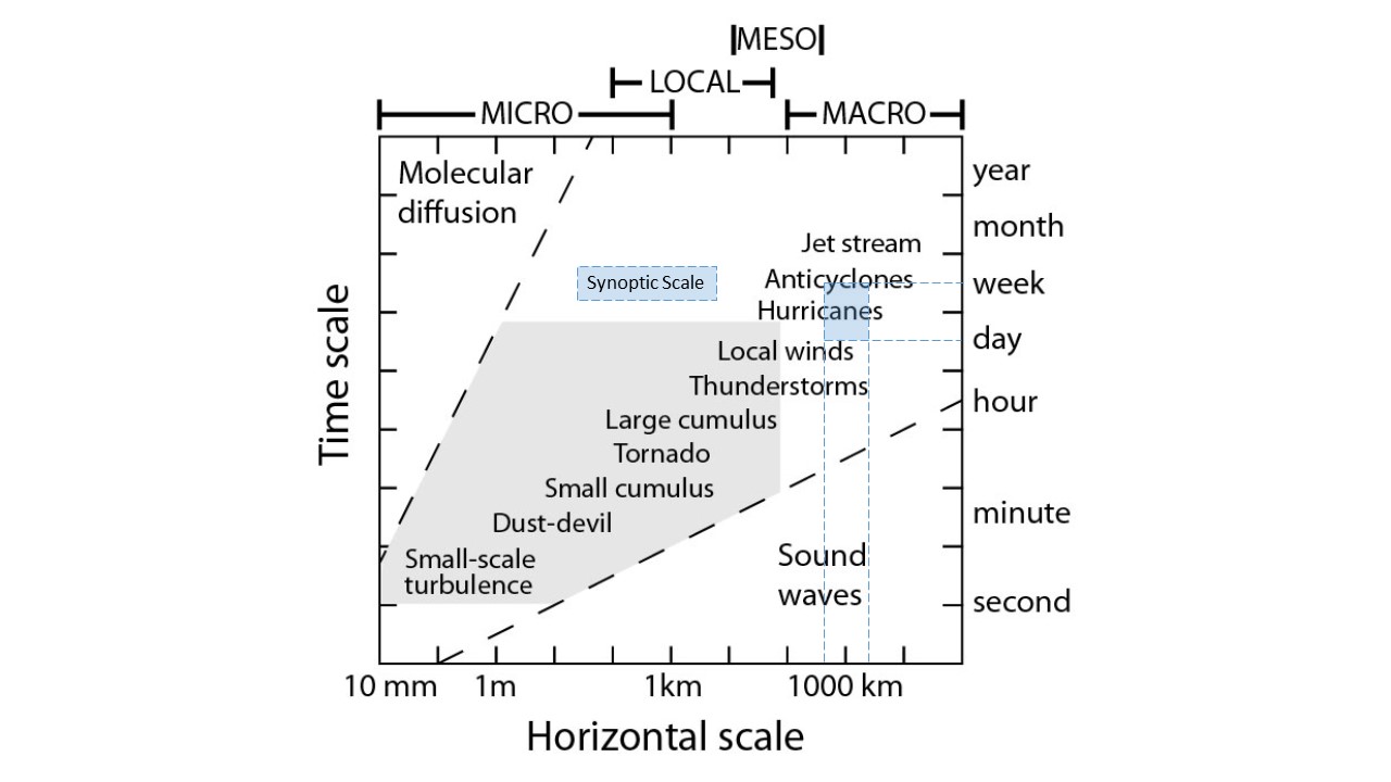
The term “synoptic” is a general term referring to weather features that reach or exceed roughly 1000km across in scale. In the mid-latitudes (most of Canada), most major high and low-pressure systems fall into this size category, as well as large hurricanes. Systems of this size, as depicted in this figure, usually last a few days.
Image Source: Environment and Climate Change Canada
Dissipation
Synoptic systems are supported by large-scale, upper-level physical systems. Atmospheric waves and large-scale temperature gradients, to name a couple, are large drivers and supporters of synoptic scale systems. When those phenomena weaken, the systems begin to lose integrity and dissipate on the surface.
Duration
Weather systems of this size tend to last for a few days at a time, and will slowly become less organized, and eventually dissipate when they no longer have upper-level support feeding or sustaining their development.
For regions in the path of a moving synoptic scale system, this implies that associated conditions could persist for a few hours if the system is moving quickly, or a few days if the system is moving slowly.
Image Source: Environment and Climate Change Canada
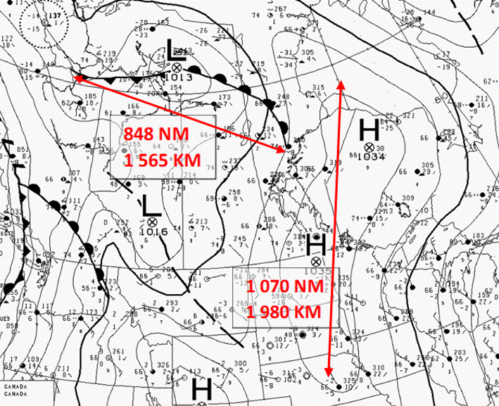
Synoptic scale forecasting is relatively simple, as the systems are so large that stations in their path are easy to identify, and portions of the systems generally have relatively stable conditions.
However, the challenge often lies in determining the exact path of the system and forecasting for stations near the end of the weather’s boundary. If the path shifts slightly, it can change a high impact forecast to nothing, or vice versa.
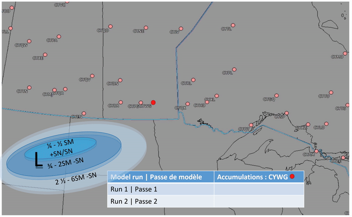
This is an example of two different model runs showing two different low tracks. Run 1 has the low-pressure system tracking 90km north of run 2, which has a large impact on the amount of snow forecast for CYWG. Whereas run 1 has 10-15cm of heavy snow over CYWG. run 2 only has 2-4cm as the heaviest band of snow misses the city.
Image Source: Environment and Climate Change Canada
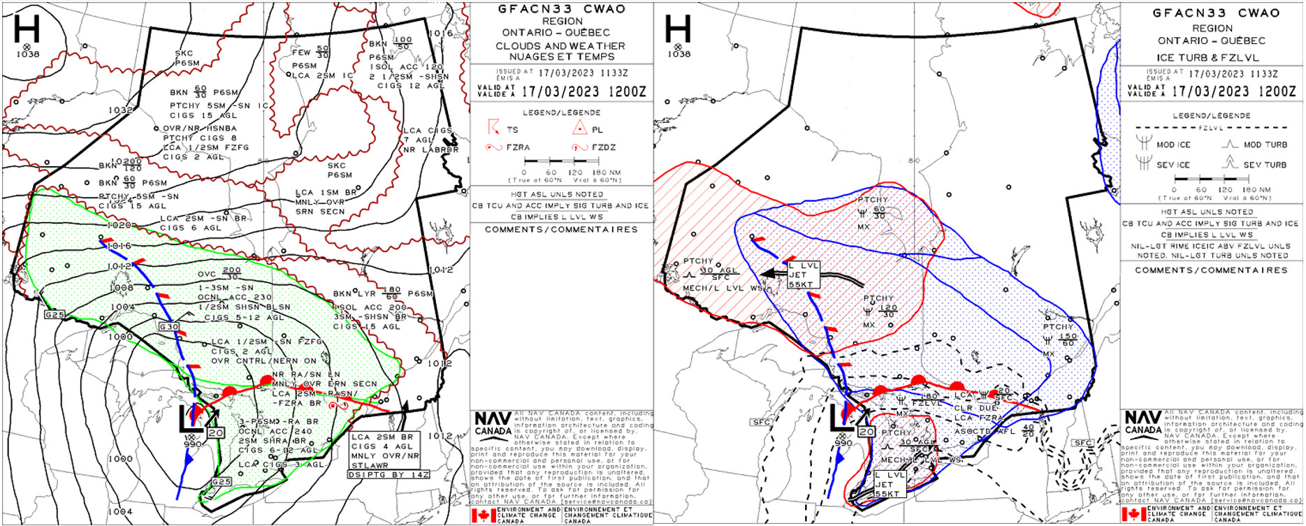
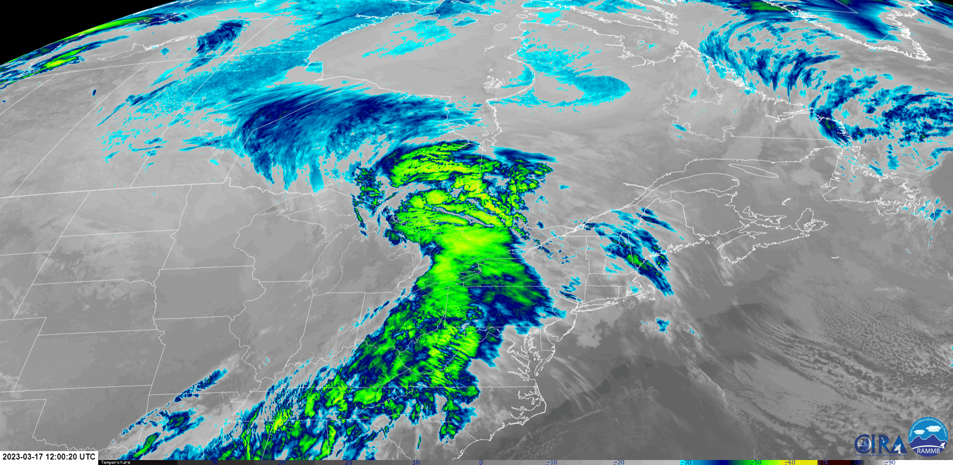
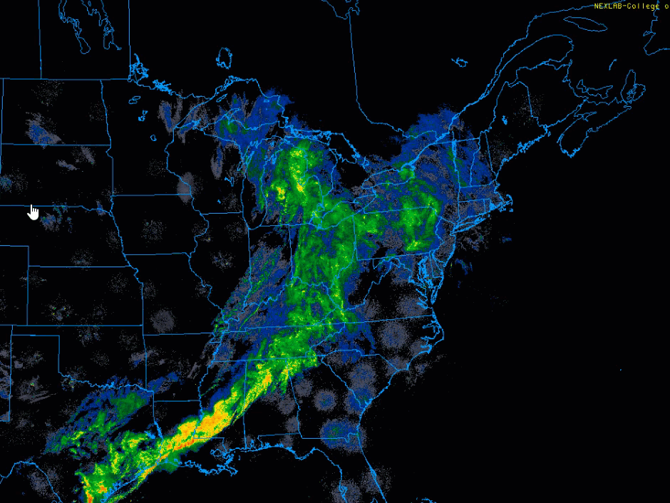
This GFA example of a synoptic-scale low-pressure system with fronts is from March 17, 2023, valid at 1200Z. Synoptic systems tend to have a wide area of coverage and can impact aviation operations at airports across large regions, as seen in these panels. The well-organized low-pressure system centered over northern Michigan and its associated frontal boundaries were expected to bring mixed precipitation and gusty winds across most of Ontario and southwestern Quebec. “Well organized” simply means precipitation present would likely be more continuous and distributed around the low and frontal features in “standard” patterns. This organization is due in part to the level of maturity of this low and the support it has across multiple levels of the atmosphere, such as low-level convergence, upper-level divergence, and overall lift/instability. Continuous precipitation was forecast around the low, indicated by the green stippled area, with embedded convection and the possibility of local freezing precipitation along the warm front. While embedded convection and localized freezing precipitation are themselves mesoscale features, many mesoscale processes occur within a synoptic scale system. In the icing and turbulence panel, this synoptic system is also forecast to produce mechanical turbulence in gusty winds across southwestern and northern Ontario as a result of two separate low-level jets impacting the region.
As a TAF represents weather conditions at a single site, they cannot directly indicate the spatial extent of a system (and whether it is synoptic, mesoscale, or smaller). However, duration of conditions in a TAF can sometimes give an indication of the size of different parts of the storm (long stretches of consistent conditions indicating a large section of the storm). Alternatively, one can assess several TAFs across a large region to see how many different sites are affected by similar conditions (taking local effects into account).
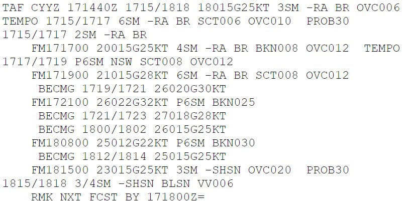
This TAF for CYYZ, forecasting conditions from 1500Z on March 17th through 1800Z the following day, provides a closer look at the impacts of a synoptic low-pressure system over a single point. Initially, continuous rain in IFR conditions is forecast as CYYZ is located in the warm sector of the low as shown by the southerly winds, and corresponding with the GFA. Between 1900Z and 2100Z, the cold front associated with the low is forecast to sweep through, which is expected to bring an abrupt wind shift and gusty westerly winds that gradually weaken as the pressure gradient tied to the synoptic system begins to slacken.
This station describes 6 hours of precipitation conditions, four within the continuous rain of the warm sector, and two describing the transition of the cold front passing, bringing in drier conditions. Previous issues of this forecast likely showed much longer periods of rain conditions, due to the expected synoptic size of the system, and how long it remained over CYYZ.
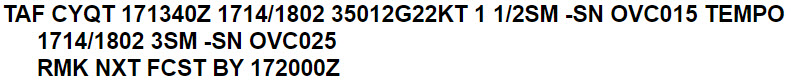
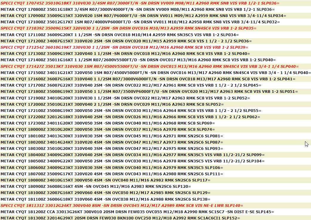
This second TAF, a forecast from March 17 at 1400Z to March 18 at 0200Z at Thunder Bay, ON (CYQT) for the same low-pressure system. It shows the consistent conditions forecast for the airport through a 12-hour period, another common signature of synoptic lows, when no precipitation type changes, or wind shifts are expected. CYQT is approximately 900km northwest of CYYZ and yet is also feeling the impact of this low with straight snow and gusty northerly winds expected through the entire TAF’s validity period. Again, the duration of these conditions at this station suggest either a slow moving, or very large (synoptic) system passing through.
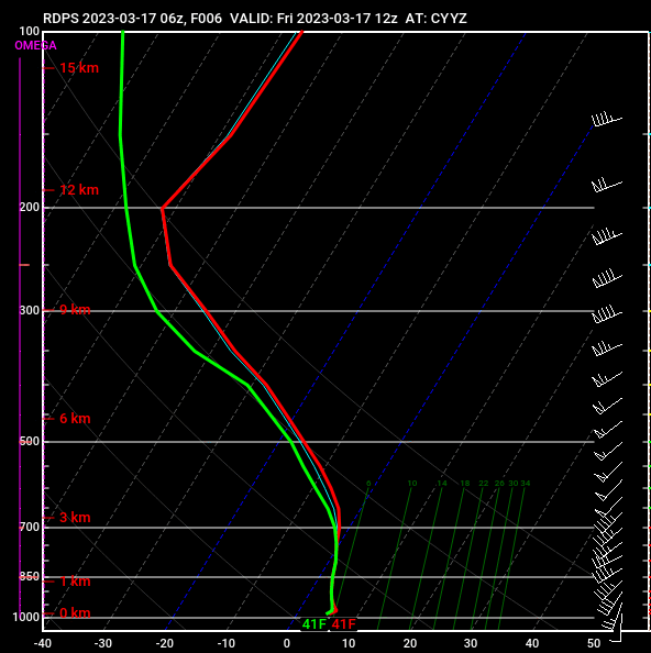
These RDPS model atmospheric profiles for CYYZ on March 17 predict conditions from 1200Z to 2100Z on March 18th. The GFA is the best way to visualize the large-scale impacts of a synoptic system like the low shown in this example. These profiles, specific to forecast model predictions at CYYZ, are a point forecast at one station embedded in this synoptic scale flow. Animating these images chronologically shows how weather within a synoptic scale environment change at one station over time. Between 1200Z and 1800Z the 17th, profiles show the deep moisture associated with the low along with relatively stable conditions low. This is both shown in the GFA as continuous precipitation and echoed in the TAF, where the forecaster provides additional information on precipitation intensity and timing. By 2100Z on the 17th, winds are forecast to dramatically shift west with the cold front passage and much of the column dries up. This frontal passage is also captured in the TAF, as indicated by the wind shift and the changes in forecast precipitation and ceilings/visibilities. The vertical wind profile also shifts from a veering to backing profile, indicating the onset of cold air advection behind cold front associated with the synoptic low. Watching as these profiles change over time can provide clues about where the station is located within that large-scale flow, and what potential weather can be expected.
Image Source: Pivotal Weather
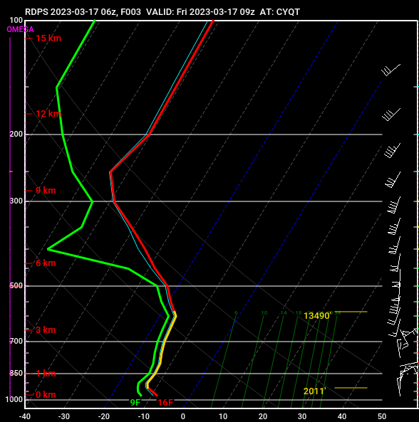
RDPS model derived atmospheric profiles show forecast conditions from March 17th at 0900Z through 2100Z on the 18th at Thunder Bay, ON (CYQT). These profiles are consistent with continuous snow, as temperatures are expected to be below freezing, and the air to be saturated up to the tropopause. The duration of this snow is primarily driven by the massive extent of the continuous precipitation generated by this low-pressure system passing over the station and region, even though the center of the low is over 1000 km away. Improvement is only expected at 1500Z on March 18th as mid-levels dry out once the low’s precipitation is finally expected to move out of the CYQT area.
Image Source: Pivotal Weather
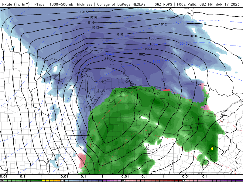
To the left is a graphical representation of the RDPS model derived precipitation type forecast between March 17th at 0900Z to 1800Z on March 18th. This synoptic low impacts multiple provinces and states simultaneously with strong winds and mixed precipitation, providing an excellent example of precipitation and a low-pressure system on the synoptic scale.
Image Source: College of DuPage
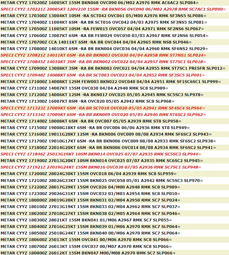
Though the size of weather features cannot be directly determined by looking at observations, using METAR/SPECI and TAFs in combination with graphical products helps define impacts both on the large-scale and smaller. Not only that, but the characteristics of synoptic features, such as fronts and pressure centers, can often be easily identified in surface observations. On March 17, 2023 between 1200Z-1800Z, Toronto was in the warm sector of the low (as indicated on the GFA) experiencing continuous rain in southeasterly/southerly winds. The cold frontal passage occurred at 1846Z, which was marked by a wind shift, dropping surface temperature, and the lowest levels of the atmosphere starting to destabilize. The pressure gradient associated with this synoptic feature gave strong winds on the backside of the cold front once the lowest levels of the atmosphere destabilized in the colder air.
Image Source: OGIMET
Observations from CYQT show persistent snowfall over a long period of time, one of the signatures of remaining within the same sector of a low-pressure system. Large systems are composed of many different air masses with their own characteristics, so the duration of consistent conditions over one location for such a long period of time indicates how massive this sector of the low system is. Winds also remain steady in both strength and direction (including gusts) underlining the strength and expansive impact of the tighter pressure gradient seen in this synoptic low.
Image Source: OGIMET
Hazards associated with all large-scale phenomena such as cold fronts, warm fronts, troughs, and low-pressure systems.
Operations Duty Managers
Synoptic events broaden the planning perspective to include peripheral impacts.
For CYYZ
For CYUL
Synoptic events can lead to TMIs at other airports and this does have an impact on us:
This term is a general term that gives a rough estimate of potential weather duration but otherwise is more nice to know versus need to know. It sets the stage for what comes next.
Weather features of any scale are all part of an FSS weather watch and are carefully noted when coming on duty with the shift change briefing, then monitored throughout the shift. The effect of scale translates directly to duration of weather phenomena, as a rule of thumb. The larger the system, the longer its effects will last.
Advisory Sites deal exclusively in the microscale/low end of mesoscale. Our weather picture is bigger than that, but the data we pass along through the advisory is constrained to about 20 miles (or line of sight) of our airport.
In our case, this weather would completely cover our entire airspace, if the weather is the same everywhere then it's quite simple, there's nothing to deviate around, there's nothing to bypass, it's just "consistently bad everywhere". Often if it's really bad and covered up, we'll be less busy in these situations as there is much less going on.
Large scale systems impact major airports mostly when they pass directly over them. The airport can see a significantly reduced AAR for an undetermined amount of time while the system passes through, causing major delays for departures and arrivals and sometimes filling the airport beyond its capacity.
Large scale weather systems (especially lines of thunderstorms) have the greatest impact on low level ATC. When these systems lead to TMIs, enroute controllers step up to support changes in arrival rates due to airport closures or capacity constraints.
Understanding the larger synoptic features in our day-to-day planning is important for general understanding and anticipation of the operational day that is in store. This is true whether we are considering a major or regional airport. Identifying the weather systems involved, whether they are invading or retreating, leads a dispatcher to dig deeper into other, more specific weather forecasting products. Synoptic weather features impact many airports over a broad area creating challenging weather conditions and a difficult day.
The assessment we conduct during flight planning will mostly rely on TAFs. Let’s say the destination airport is right in the middle of a large-scale weather pattern, the dispatcher will more broadly search for an adequate alternate, meaning further away.