METAR Code
N/A
Weather Symbol
A pressure gradient is largely responsible for air circulation (wind) and is a good indicator of how forceful winds will be over the area of interest, with a “tight” gradient (a large change in atmospheric pressure over a shorter horizontal distance) indicating generally very fast and strong winds.
The shape of the pressure gradient can also aid in determining general wind direction around high and low-pressure systems; however, this can be modified by local effects, topography, and significant weather.
Gap winds and wind channeling are small scale but can both cause significant wind shear and turbulence.
The pressure gradient is the rate of change of atmospheric pressure over a horizontal distance.
Wind channeling is the increase in wind speed that occurs due to the constricting of air passing through a narrow topographical feature (such as a valley) or man-made feature (such as tall buildings).
Associated terms coming soon:
Low-pressure system, high-pressure system, and wind channeling are all terms associated with a pressure gradient that will be coming soon to the Aviation Meteorology Reference.
A pressure gradient will form when there is a difference in air pressure between two points in the atmosphere. As a rule, fluids – including air – naturally move from areas of high to low pressure, in an attempt to equalize the imbalance. This flow of air is known as wind, and the force pushing the air from high to low pressure is known as the “pressure gradient force”.
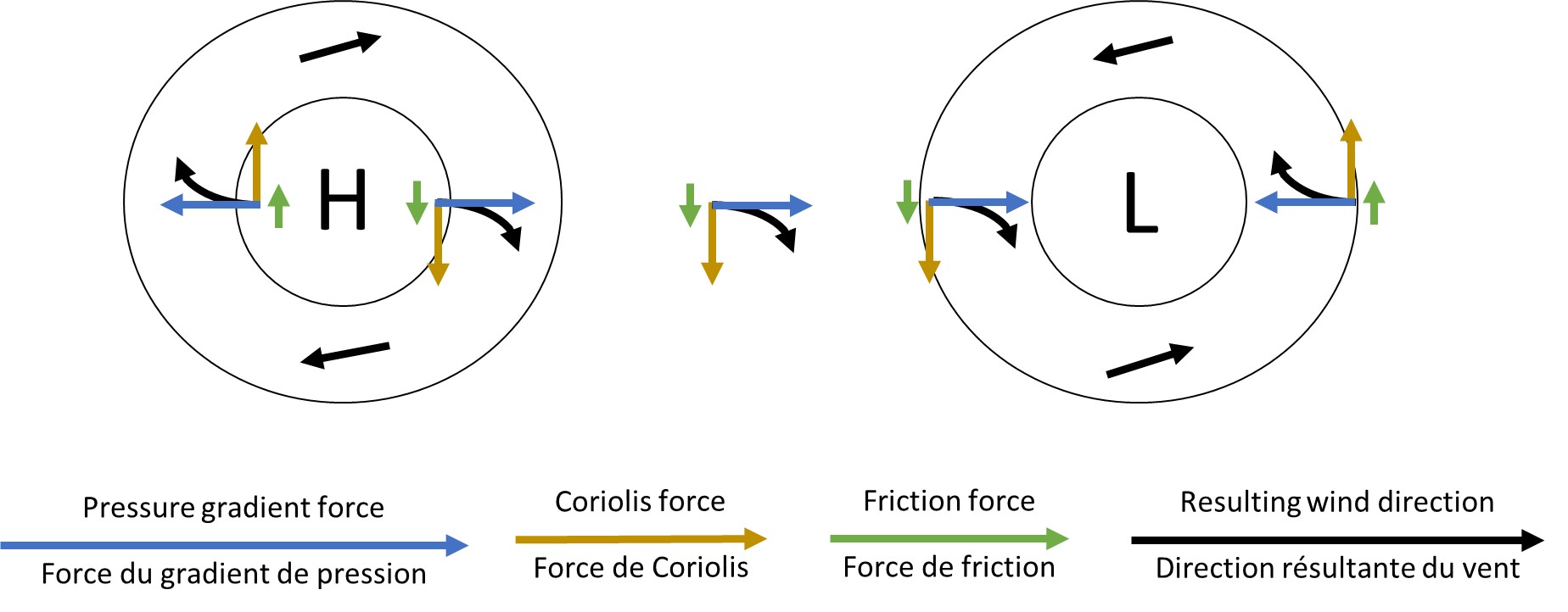
This image shows an idealized flow around high and low-pressure centers. As air attempts to flow away from high pressure, and toward low pressure (blue arrows) in the Northern Hemisphere, it is curved to the right of its path by the Coriolis force (yellow arrows). Friction will oppose the pressure gradient force and Coriolis slightly. This will continue until the pressure gradient, friction, and Coriolis forces are completely balanced, which directs the wind to spiral slightly inward toward the low pressure/away from high pressure. While other, real-world factors can alter these flows, this is the overall resulting flow of wind.
The pressure gradient force drives the wind, and it is directly proportional to the difference in pressure over a given distance. The greater the pressure difference, the stronger the pressure gradient force and the faster the wind will blow. In the Northern Hemisphere however, the Coriolis force – a force generated due to the turning of the spherical Earth - pushes moving air to the right of its path. However, as this wind is moving over rough surface terrain, friction also reduces the speed at which air can move from one place to another. Observed wind patterns are the result of the equilibrium between these forces.
The result is a spiraling wind motion around the pressure centers, largely following isobars, but not perfectly. Winds spiral slightly inward around a low, and slightly outward around a high. The frictional force is present due to the wind being in contact with the earth’s surface, and as one moves up through the atmosphere, friction disappears, and winds will follow the isobar pattern more exactly.
Image Source: Environment and Climate Change Canada
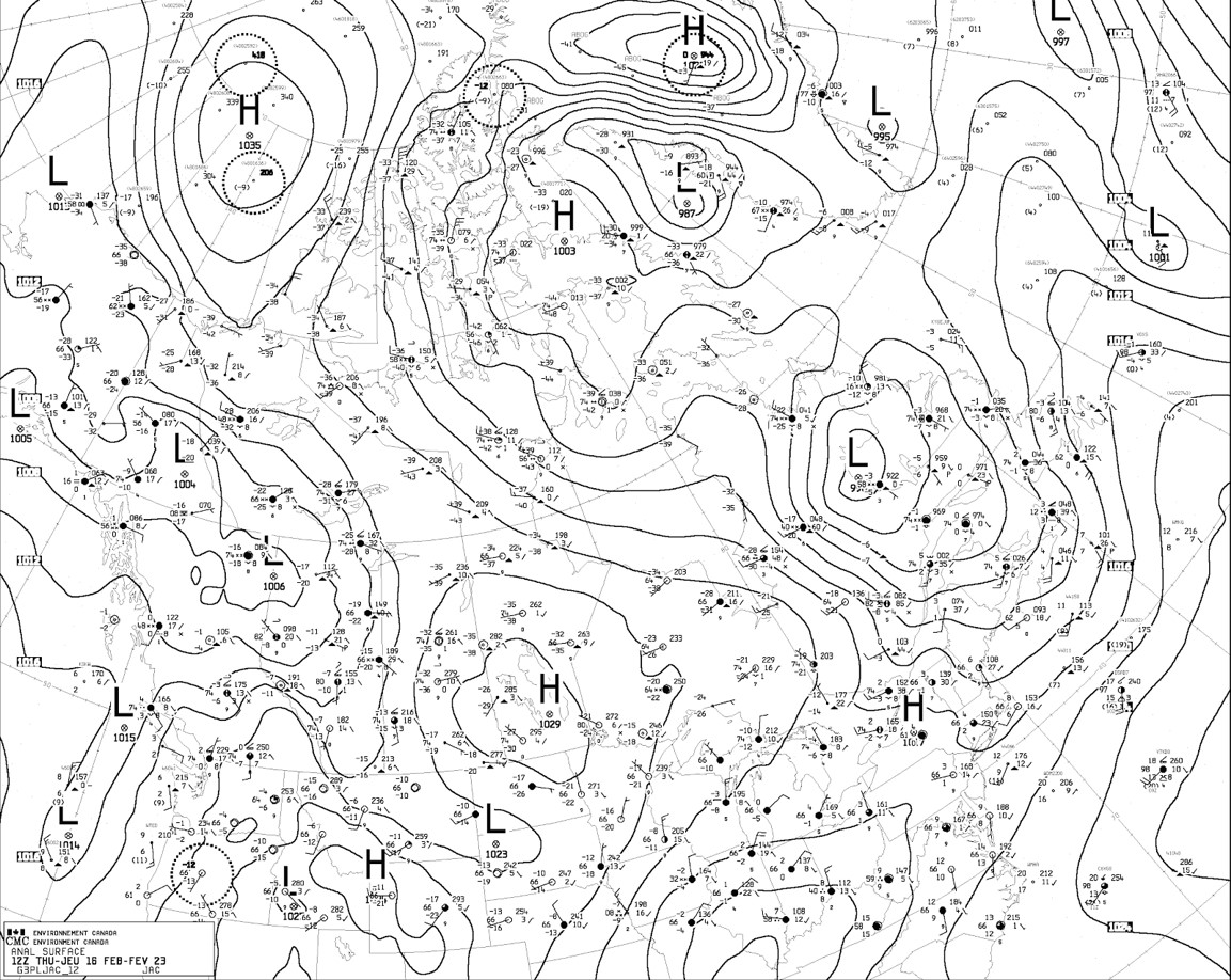
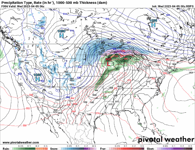
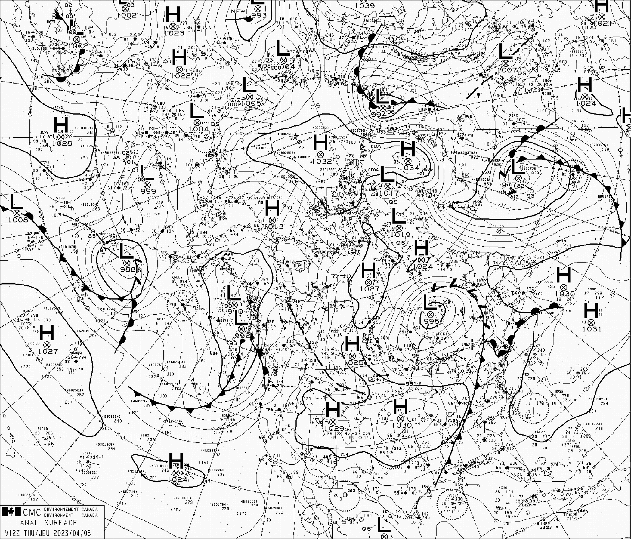
The density of isobars (lines of equal pressure) represents the rate of change of pressure across an area. Lots of isobars close together is indicative of a large change in pressure over a small region, which generates a larger pressure gradient force and therefore stronger winds to attempt to equalize pressure.
High-pressure systems are generally broad and have a small pressure gradient. Conversely, low-pressure systems have smaller centres and therefore much larger pressure gradients (denser isobars), and generally stronger winds. The extreme case is a hurricane, with very low central pressure, a high-pressure gradient (tightly packed isobars), and dangerously strong winds.
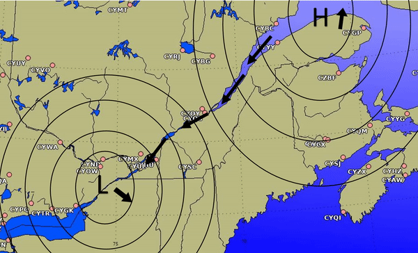
This surface analysis is a demonstration of pressure gradient over Canada. Isobars are typically less densely packed around a high-pressure center, while they become closer together around a low-pressure center.
Image Source: Environment and Climate Change Canada
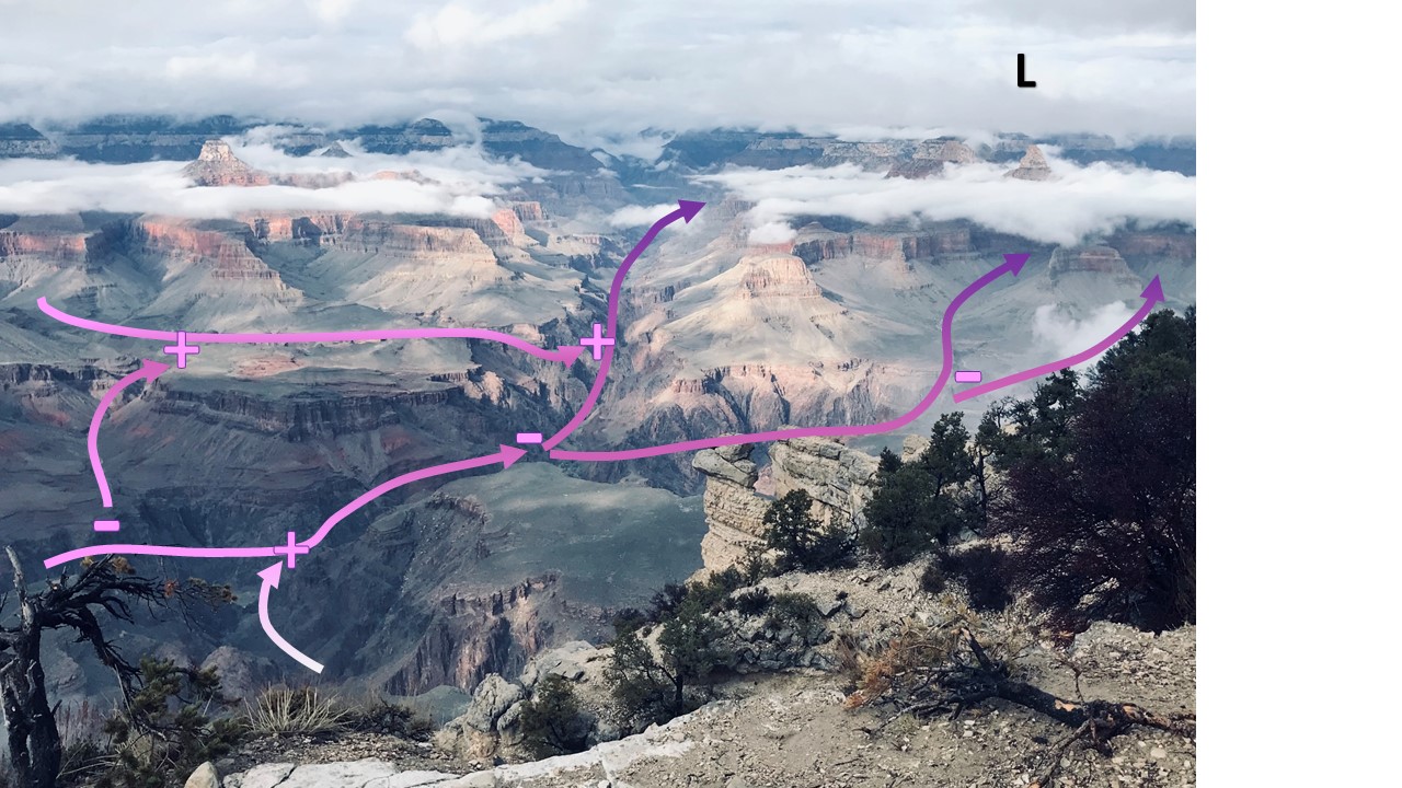
This is a simplified view of wind forced through valleys and how they interact. When several air streams meet and enter a narrow valley, air speed will increase, and may be associated with updrafts. Conversely, when air streams are split into several valleys, the wind speed will decrease, and can cause downdrafts.
When a pressure centre gets closer to another (a low moving toward a ridge, for example), the pressure gradient between them will increase significantly, increasing the winds dramatically.
In valleys and complex, mountainous terrain, however, pressure gradients can cause a very different effect. Winds in such complex terrain will typically follow the valley terrain and are more dependent on the direct pressure gradient forces (meaning that air will flow more directly from high to low pressure). This effect is strongest when pressure gradients lie exactly perpendicular to the valley and have large differences in central pressure.
To complicate matters further, in terrain with interconnected valleys, winds will constantly be separating, and crashing together in locations where valleys split and join. When wind splits into multiple valleys, the speed is reduced (as the force is divided) and can cause downdrafts. Conversely, when winds converge and move into a single valley, the wind speed increases (force of several streams combines), which can also cause updrafts. And naturally, as winds are traveling through terrain in a different direction than winds aloft (above terrain), there can also be significant wind shear moving into and out of valleys.
Image Source: Environment and Climate Change Canada
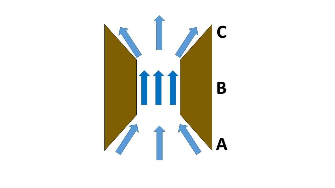
Lastly, when such wind is channeled through a narrow gap or passageway (such as through small gaps in mountain ranges, or where the Saguenay River meets the St. Lawrence River), it can be suddenly accelerated as it passes through, making a localized, but extremely dangerous change in wind speed. This phenomenon is known as a “gap wind”.
This image is a simplified depiction of gap winds.
A) Winds converge at a narrow opening in terrain, creating a local area of high pressure on the windward side.
B) Wind accelerates as it pushes through from the local high pressure at A, toward the relatively lower pressure region at C.
C) Accelerated winds escape the narrow opening and begin to slow, causing a very local, dangerous jet downstream of the opening in terrain.
Image Source: Environment and Climate Change Canada