METAR Code
FG
Weather Symbol

Radiation fog can cause sudden reduction in flight conditions, often from a clear sky to very low visibility and ceilings. While typically thin, low conditions can persist for several hours.
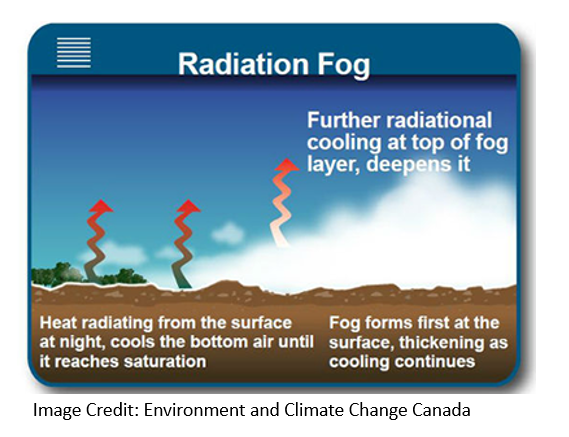
A layer of normally thin fog that develops overnight under clear skies, as surface air is cooled to 100% humidity.
Associated terms coming soon:
Dewpoint, high-pressure system, inversion, and mesoscale are all terms associated with radiation fog that will be coming soon to the Aviation Meteorology Reference.
Radiation fog develops on clear nights, generally under a ridge, when humidity is high. Under a clear sky, the earth's surface, and consequently the layer of air at the surface, cools steadily overnight. If the air mass at the surface is able to cool to the dew point temperature and reach 100% humidity, there is a risk of radiation fog forming. Light surface winds help mix the air, until a pool of mist begins to form. When winds are too weak (near zero) however, the air cannot be sufficiently mixed to form mist, and the excess moisture will settle onto the ground, forming dew (or frost, when temperatures are below freezing). Strong winds can inhibit this process, as air over the cooling surface moves too quickly to cool to saturation, and will disperse any forming radiation fog.
This pool of mist can continue to grow, reducing runway visibility from VFR to half a mile or less in less than an hour as it grows in depth overnight. When this process occurs in the winter, freezing fog will form and will increase icing on the runway, or aircraft within the fog.
Image source: Environment and Climate Change Canada
Dissipation
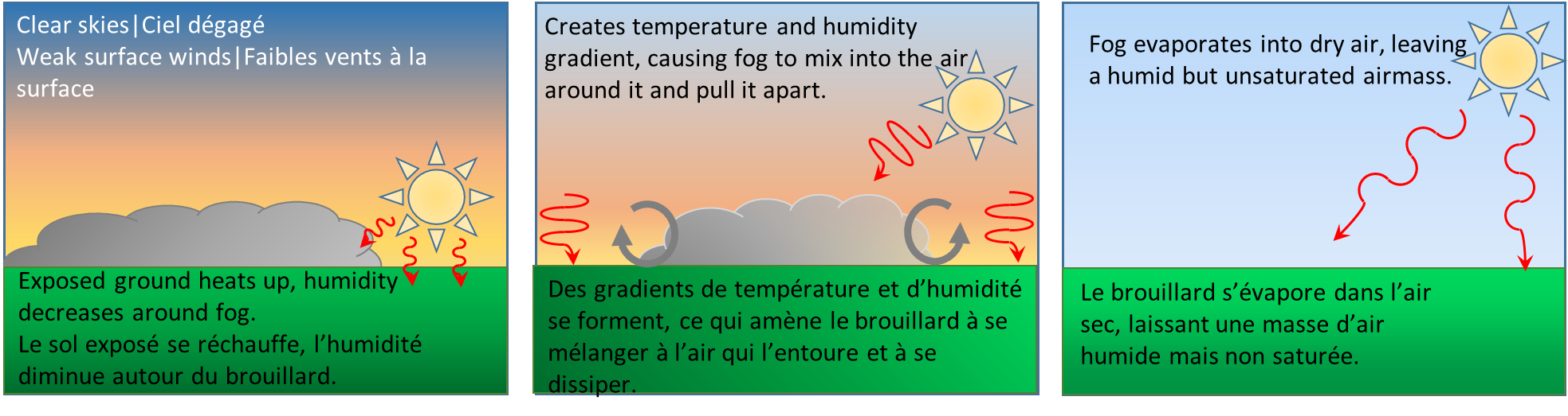
Idealized process of radiation fog dissipating in the morning. While radiation fog tends to burn off rapidly in the morning (especially in peak summer months), visibility can actually decrease slightly before beginning to burn off. As the ground heats in the morning, there is some additional mixing at the surface due to the new temperature differences at the edges of the fog. This mixing can cause the fog to condense further, lowering visibility, before the mixing at the edges begins to pull the fog apart.
Duration
When the sun comes up, the fog will start burning away at the edges, mixing and evaporating the fog into drier air around it, quickly improving conditions. Radiation fog typically burns off quickly, especially in late summer when it is quite thin. Radiation fog tends to be thicker closer to winter and takes longer to burn off, as sunlight hours are limited and the sun is weaker during the day.
Image source: Environment and Climate Change Canada
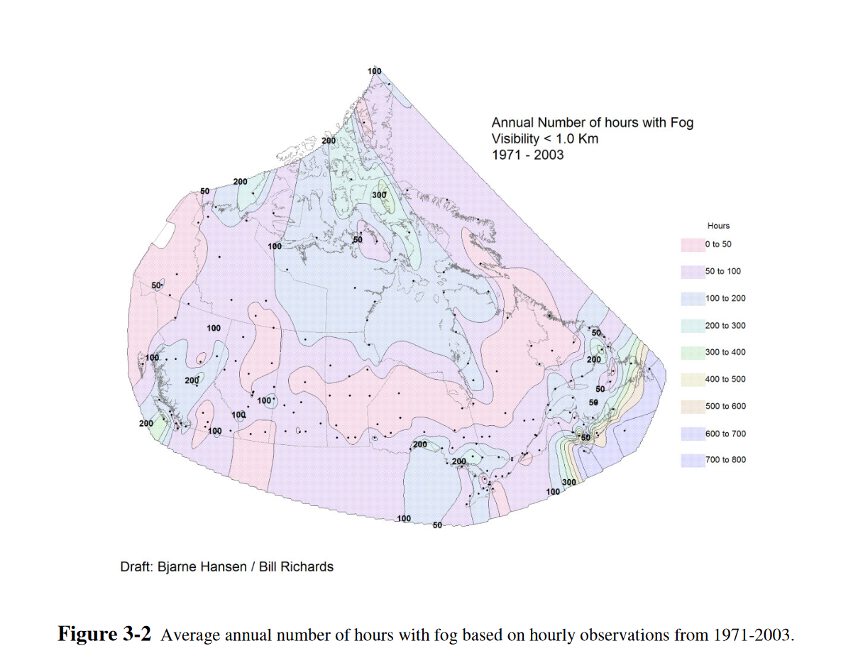
Radiation fog is most common near moisture sources (e.g. lakes, irrigated farmland), and in valleys where pools of cold air can accumulate overnight. Its development is favoured in late summer and fall when the nights are long, and humidity is relatively high. This figure indicates the average annual number of hours with fog based on hourly observations from 1971-2003.
Image source: Environment and Climate Change Canada PublicationsOpen a new window
Radiation fog poses a major forecast challenge for a variety of reasons:
Air reaching 100% humidity does not guarantee the development of fog, as it is also dependent on the strength of the surface winds, which may or may not be observable (no reporting stations nearby). While atmospheric conditions can be right for radiation fog formation, when surface wind forecasts are off by even a few knots, it can affect the formation of fog entirely. With winds that are too strong, there will be too much mixing in the lower levels and will effectively spread out the saturated air too much to “settle” into fog at the surface. Calm or no wind, however, will not mix the air enough, and leave a very thin saturated layer at the surface, promoting the formation of dew or frost instead (which could, in turn, delay the formation of fog to sunrise).
Moreover, as clear skies are required for this type of fog formation, the unexpected absence or presence of cirrus clouds aloft can also make or break a forecast. Cirrus acts as a “blanket” for the earth and prevents maximum surface cooling overnight (as energy cannot escape beyond the clouds into the high atmosphere). When cirrus is unexpectedly present, air temperatures cannot reliably cool enough to saturate. Conversely, when cirrus is expected and not present, or is far thinner than expected, the surface can fall to saturation.
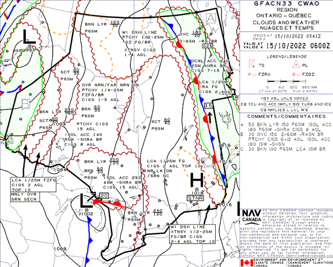
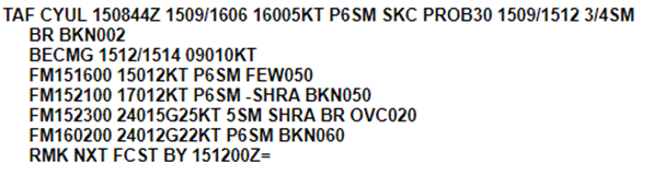
The GFA forecast valid for October 15, 2022 at 0600Z shows a quasi-stationary high-pressure system located over Quebec, with conditions ideal for the development of radiation fog. Just east of CYUL is a dashed orange line indicating a forecast of extensive fog and mist conditions with reduced ceilings and visibilities. Outside of this area, in the scattered cloud across southern Quebec and near Lake Ontario, local fog is forecast.
The CYUL TAF issued at 0844Z on October 15, 2022 captures the risk of mist as a PROB30 between 0900Z and 1200Z, with 3/4SM visibility and broken 200ft ceilings. As shown in the science explained section, elements supporting fog development such as light but not calm winds and clear skies are forecast. As discussed in Forecasting Challenges, while there are many factors that can make determining fog depth, duration and extremity of conditions, forecasters will always put the most likely timing of low conditions. This might be determined by climatology, forecast winds, onset of precipitation, or something similar.
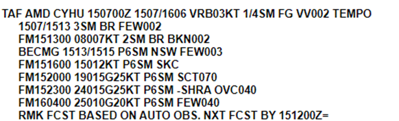
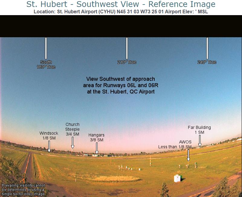
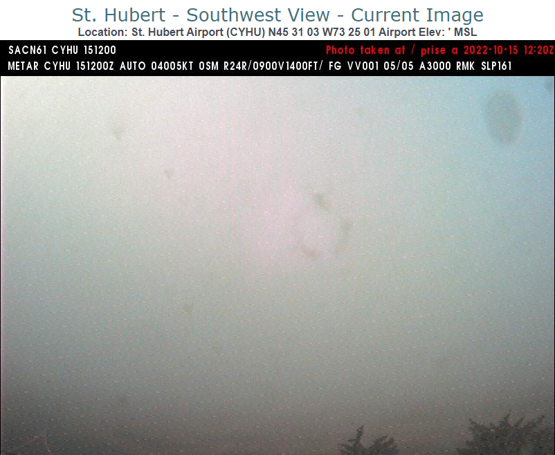
CYHU (Saint-Hubert, about 30 km east of CYUL in southern Quebec) is located within the dashed line defined in the GFA shown, and in the forecast captures the lower conditions expected and the longer duration from its formation to its dissipation. You might notice that at 0700Z, winds are forecast to be light and variable, which does not necessarily support fog development. However, fog can form under a variety of conditions, be formed elsewhere and moved (or advected) over a particular station, or already exist at the location in question by the time the forecast is sent (no longer requiring textbook conditions for development). It is important to note that forecasters are tracking all of these factors, and will only put the scenario they believe to be most likely in their forecast products.
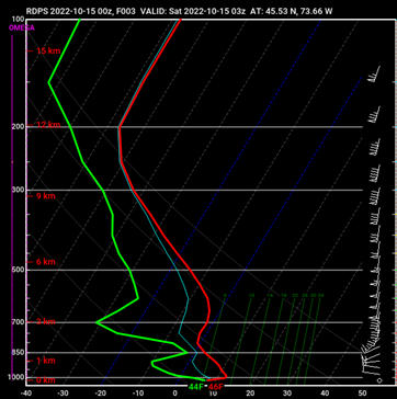
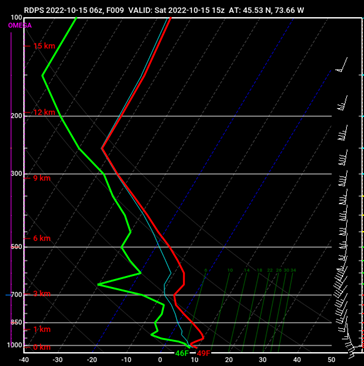
Atmospheric profiles from the RDPS forecast model provide a glimpse of atmospheric conditions leading to the development of radiation fog. These images capture the forecast state of the atmosphere before radiation fog is expected to develop, as it occurs, and its forecast dissipation.
The first profile, valid at 0300Z October 15, 2022, shows a temperature inversion expected to form in the lowest layer of the atmosphere, along with relatively high surface dewpoints. Though surface winds at this hour are forecast to be calm, the following profiles suggest winds will pick up ever so slightly, creating ideal conditions for development of radiation fog.
Image Source: Pivotal Weather
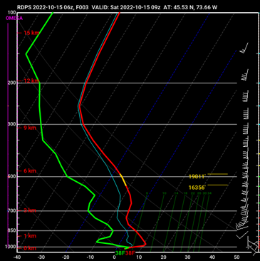
At 0900Z, there is a classic radiation fog signature in this atmospheric profile with both dewpoint and temperature equal through the lowest layers of the atmosphere. This layer, however, remains very shallow, with the dewpoint depression increasing rapidly just above it as a result of both the inversion and the presence of drier air. Winds are expected to strengthen slightly by 0900Z, enough to promote mixing and maintenance of fog.
Image Source: Pivotal Weather
In the atmospheric sounding forecast valid six hours later at 1500Z, the temperature inversion is expected to begin to erode while temperatures climb at the surface, which would cause the layer of saturated air closest to the surface to dissipate. These are all typical dissipation parameters that occur when daytime heating increases after sunrise, creating mixing at the edges of the area of fog, and marking the beginning of the end of the event.
Image Source: Pivotal Weather
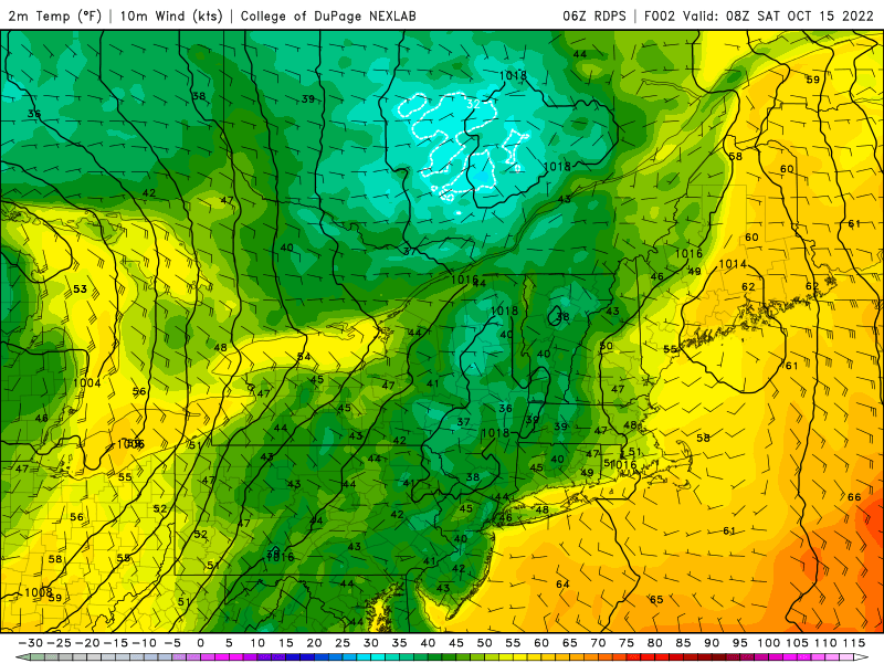
RDPS 2-meter temperature forecasts show the changes in temperatures (shown here in degrees F) at the surface between 0800Z and 1600Z October 15, 2022. It is difficult to assess fog formation from temperature alone, but comparing the 2m forecast with surface temperatures allows forecasters to assess the strength of the inversion, which is often strongest just before sunrise. When coupled with other forecast parameters, such as the light surface winds shown here, clear skies, and dewpoint temperature forecasts, forecasters can create a comprehensive radiation fog forecast.
Image Source: College of DuPage
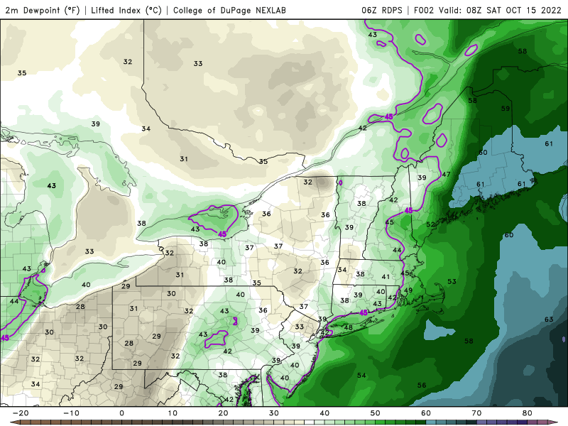
The forecast 2-meter dewpoint temperature for the same timeframe (0800Z-1600Z) on October 15th is shown in this animation. Though dewpoints steadily climb throughout the timeframe, it is when they are equal to the forecast 2-meter temperature that is most interesting to forecasters as it can help support radiation fog formation with the presence of additional ingredients.
Image Source: College of DuPage
When temperature and dewpoint are put together, relative humidity can be calculated. As shown in this RDPS forecast, also valid 0800Z-1600Z, areas along the Champlain and Saint-Lawrence River Valley, and those just north of Lake Ontario, are forecast to see high relative humidity between 0800Z and 1400Z. This, coupled with the presence of other needed ingredients for radiation fog formation, contributes to why fog is forecast in the GFA shown, and mentioned as a PROB30 or TEMPO in TAFs. As mentioned in the science explained section, the presence of high relative humidity does not guarantee fog formation, however it is a necessary ingredient and so is assessed among other factors by forecasters.
Image Source: College of DuPage
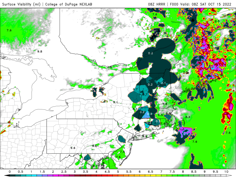
Forecasting whether radiation fog will form and, if so, how low conditions will get is among one of the biggest forecasting challenges. This forecast of surface visibility from the HRRR model, valid 0800Z-1600Z, shows the areas of possible low visibilities across the eastern townships of Quebec, the Saint-Lawrence River Valley, and patches just north of it, many of which were captured in the GFA’s orange dashed line. In the CYUL TAF, a PROB30 is initially used, in part as CYUL was expected to be just outside of the lowest conditions. This analysis, in conjunction with additional factors such as wind, topography, climatology and more, and the fact that radiation fog often occurs in patches are a few reasons why the TAF might include a PROB30 rather than a TEMPO or main condition.
Image Source: College of DuPage
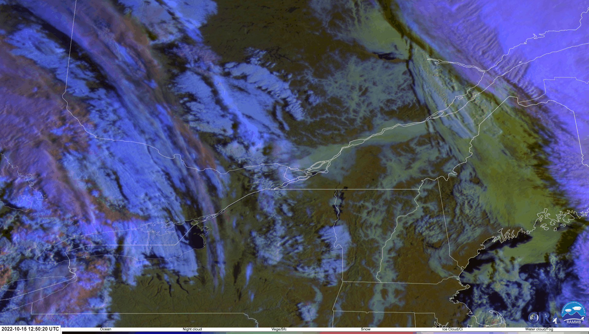
Day snow/fog multispectral satellite imageryOpen a new window valid between 1250Z and 1440Z on October 15, 2022 shows low-lying radiation fog across much of the Saint-Lawrence River Valley, eastern townships, areas north of the river and into the Saguenay region, and into Vermont and New Hampshire.. The start of the dissipation phase can be seen at the late stages of the GIF as the areas of radiation fog begin to “shrink” from the edges toward the center. This “outside-in” dissipation is due to the outside edges being exposed to warming ground just beside them as the sun rises, where mixing occurs, evaporating the fog from the outside-in.
Image Source: CIRA
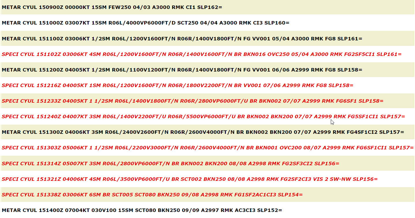
METARs and SPECIs from CYUL on October 15, 2022 show conditions rapidly drop in fog and mist, with both visibility and ceiling height varying considerably throughout the 1100Z start time to 1400Z dissipation time. This variability can be seen with radiation fog, especially in shallow events. Temperature and dewpoint fluctuate slightly but remain either equal or within one degree of one another. Oftentimes, for stations that report RVR this will be the first indicator for forecasters that fog is approaching, yet not abundant enough to warrant a SPECI. Stations with live RVRs are monitored closely in situations where fog is expected.
Image Source: OGIMET
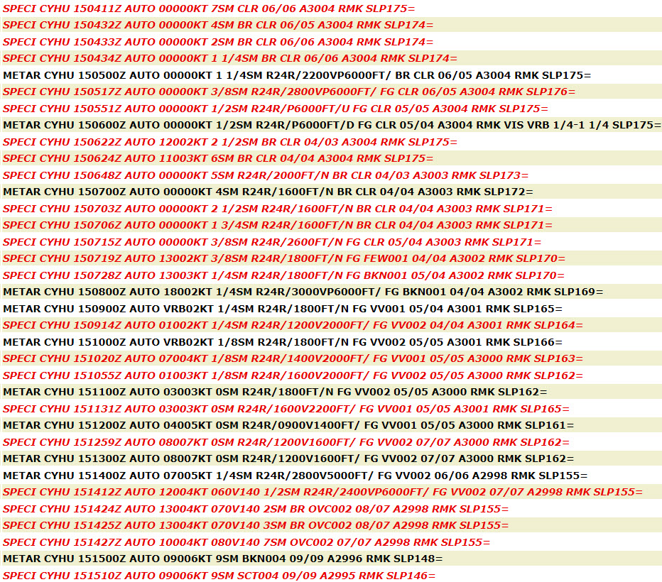
The CYHU (Saint-Hubert) TAF forecasts lower conditions in fog and a longer duration of the event. As shown in strategic charts and the GFA, CYHU is located in an area of ingredients more favorable for extensive radiation fog development. As such, conditions are reflected as being more likely to be lower and maintained as such when compared to the edges of the fog such as at CYUL.
Indeed, METARs at CYHU show less variability in visibilities once fog settles in near 0715Z. The event lasts significantly longer than CYUL, with the first mention of fog in a SPECI at 0517Z and the last at 1412Z, though low cloud doesn’t scatter out until 1510Z. The TAF indicated fog dissipating by 1300Z, which was amended and extended later in the morning. This happens and is an example of one of the other inherent difficulties in forecasting the dissipation of fog and/or low cloud in shoulder seasons when the sun is not as strong in comparison to summer months, and it takes longer to burn off cloud.
Image Source: OGIMET
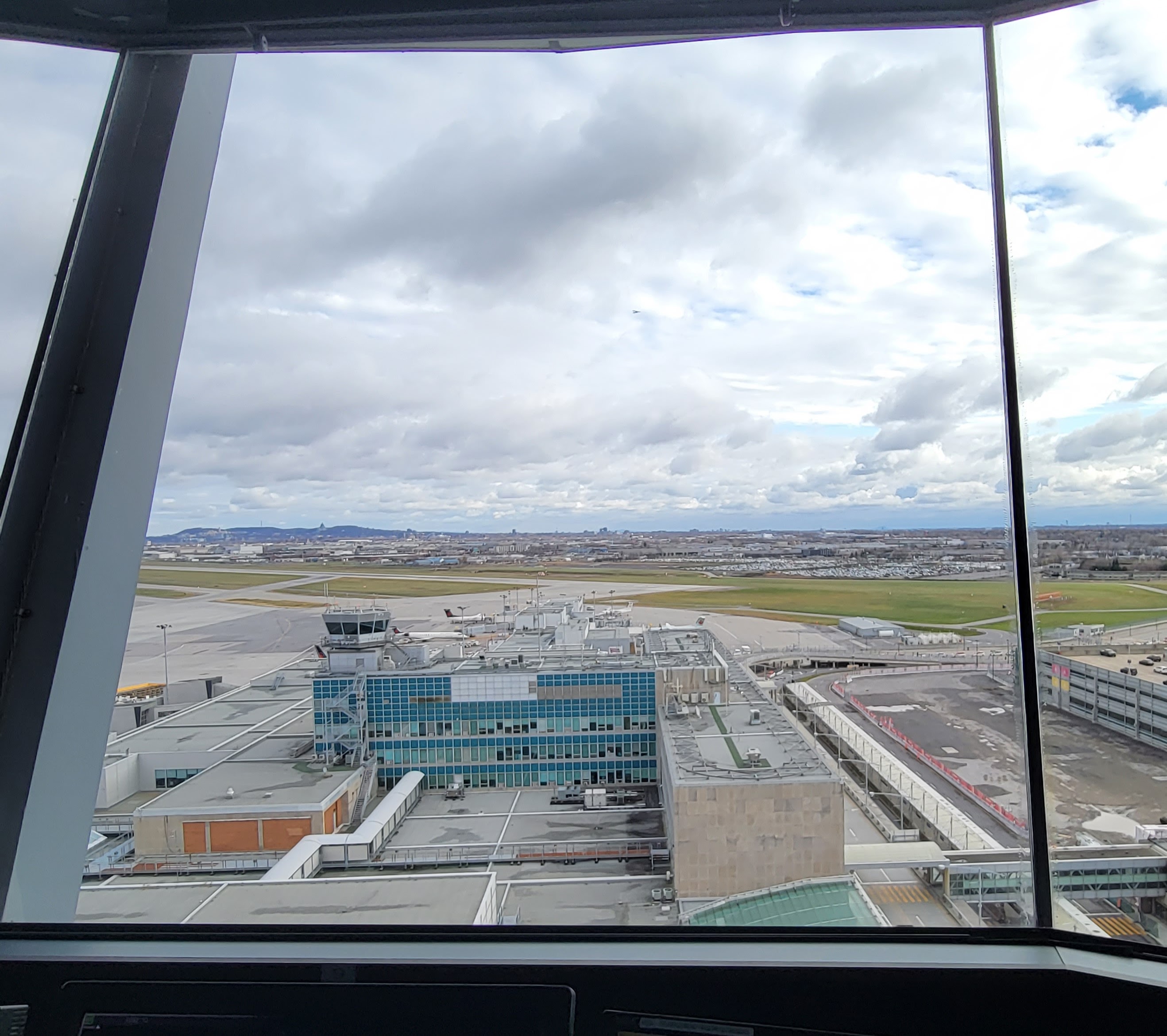
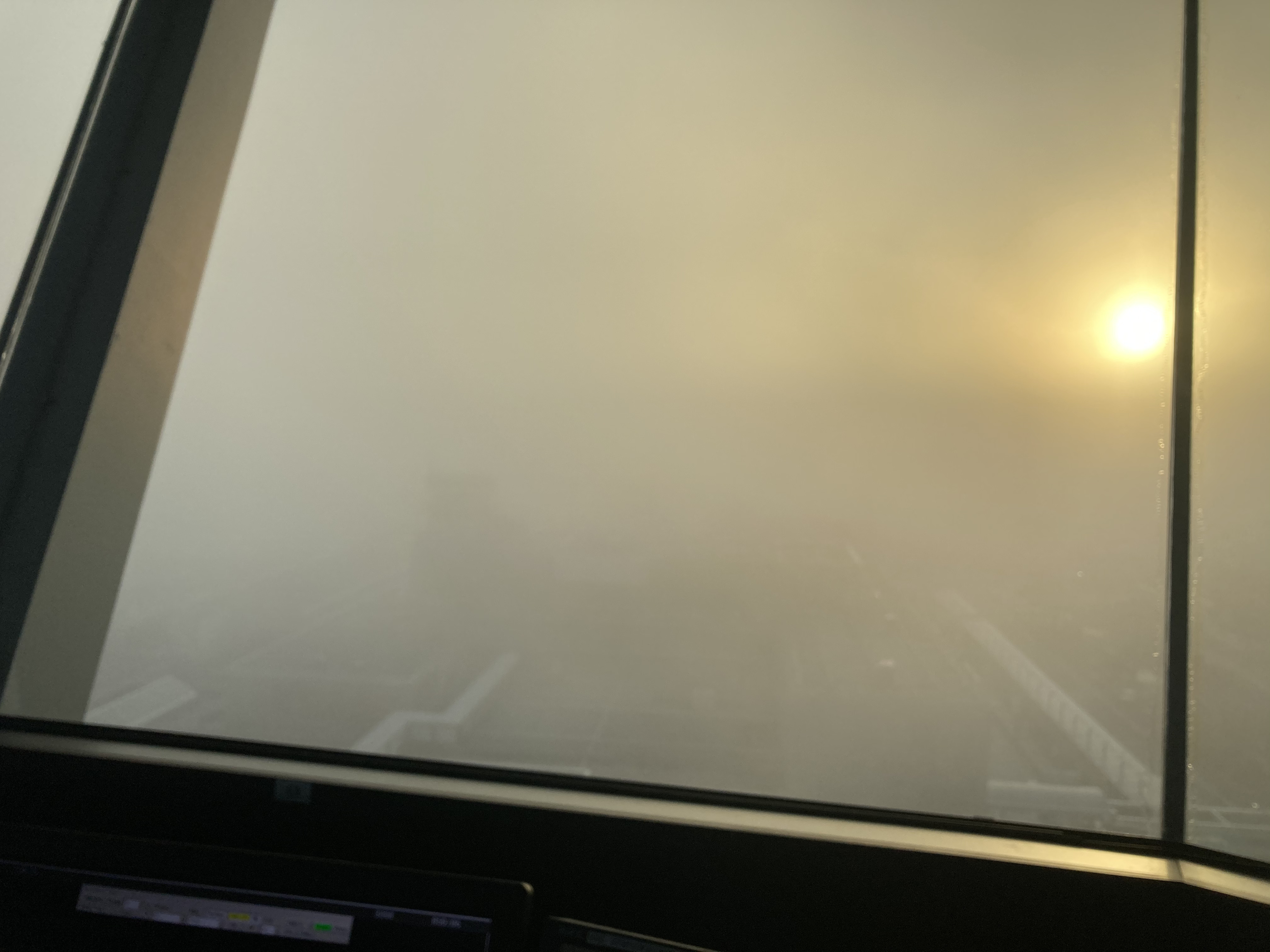
This is a snapshot taken by the tower supervisor just after sunrise on the morning of October 15, 2022. Compared to CYHU (Saint-Hubert) a few more landmarks are visible including, just barely, the apron tower and the sun through the fog. As seen in METARs, observations at CYUL show more fluctuations when compared to those at CYHU. CYUL remained on the edge of the densest areas of radiation fog throughout this event and therefore saw a later onset, more variability, and an earlier dissipation.
Low visibility and/or ceilings yield various impacts depending on available aircraft and airport systems as well as crew certifications and capabilities. Loss of arrival or departure capabilities, loss of visual cues possible.
In CYYZ, we rely on the forecasts from our third-party weather forecast service provider and the TAF to indicate reduced visibility, especially if it is expected to drop below 1SM. We would also monitor the air and dew point temperatures as indicators of the possibility of fog.
Since forecasting fog can be difficult, response to fog events are more reactive than proactive (e.g. implementation of the Low Visibility Operations (LVOP)). From a preparation perspective, review of LVOP standard operating procedures as well as ensuring the minimum equipment list (MEL) for the airfield are completed.
Because there are only three runways available for LVOP once RVR decreases to below 1,200ft (two arrival/departure runways – 05 and 06L – and one departure only – 33R), work on these three surfaces that could affect their availability for LVOP is scheduled outside the times of the year where there is a higher risk of fog. Otherwise, a way to recall the surface would be required so the impact to runway capacity is not so significant.
In CYVR, typically, we activate our LVOP when conditions are trending towards half of a statute mile but even prior to reaching those values ATC is likely to request that we set up for those operations on the airfield. This would mean restricting construction activities, removal of non-essential personnel from the airfield such as driver training, maintenance activities as required until the conditions improve.
We rely on the information disseminated from Environment Canada, the TAF and IBM Weather Forecasting contract services to indicate fog risks that could potentially impact airport operations. Our main objective is ensuring that we are prepared in case the fog materializes and this means the field lighting is inspected and ready to be available for LVOP.
Given our location, and coastal environment we tend to be prone to fog events which can contribute to increased costs:
Operations Duty Managers
Reductions in visibility can impact operations any time it deteriorates below 2SM. True impacts at an airport depend on the capabilities on the airfield specific to each runway, including the available instrumentation and lighting capabilities. Not all runways have the same capabilities, making it possible that the best runway for foggy conditions is not available because the prevailing wind is forcing operations on a different configuration. For example, in CYUL it is only 06L that has the best capabilities to operate in foggy conditions (CAT II operations). No other runway at the airport is certified to that same level, meaning that foggy conditions requiring CAT II or III (worse) while on a 24L/R or single runway 06R operation will lead to reductions in flow far more drastic than delays already felt if 06L was available. Of note specifically to forecasters: this specific caveat can change the landing/alternate limits based on which runway is active (among other factors specific to aircraft type/crew certification).
Because of the difficult nature of forecasting fog, additional weather forecast products can be referenced to determine its extent and severity. Wind direction off Lake Ontario with a close temp/dew point spread can be a key indicator along with conditions at Billy Bishop. Surrounding stations on a METAR tool can also be good indicators when coupled with webcams (Burlington, Billy Bishop, or Brampton).
ATC (Major Tower)
Fog impacts at major towers are dependent on multiple factors specific to aviation. These factors include airport equipment, reduced/low-visibility plans, runway lighting and certification, combined with airline-specific capabilities and crew training. The same visibility and ceiling may have two completely different resultant impacts at two different airports, depending on all the factors listed. Fog events require some basic preparation.
Examples below are for CYUL:
ATC (Regional Tower)
Fog impacts at regional towers are dependent on multiple factors specific to aviation. These factors include airport equipment, reduced/low-visibility plans, runway lighting and certification, combined with airline-specific capabilities and crew training. The same visibility and ceiling may have two completely different resultant impacts at two different airports, depending on all the factors listed.
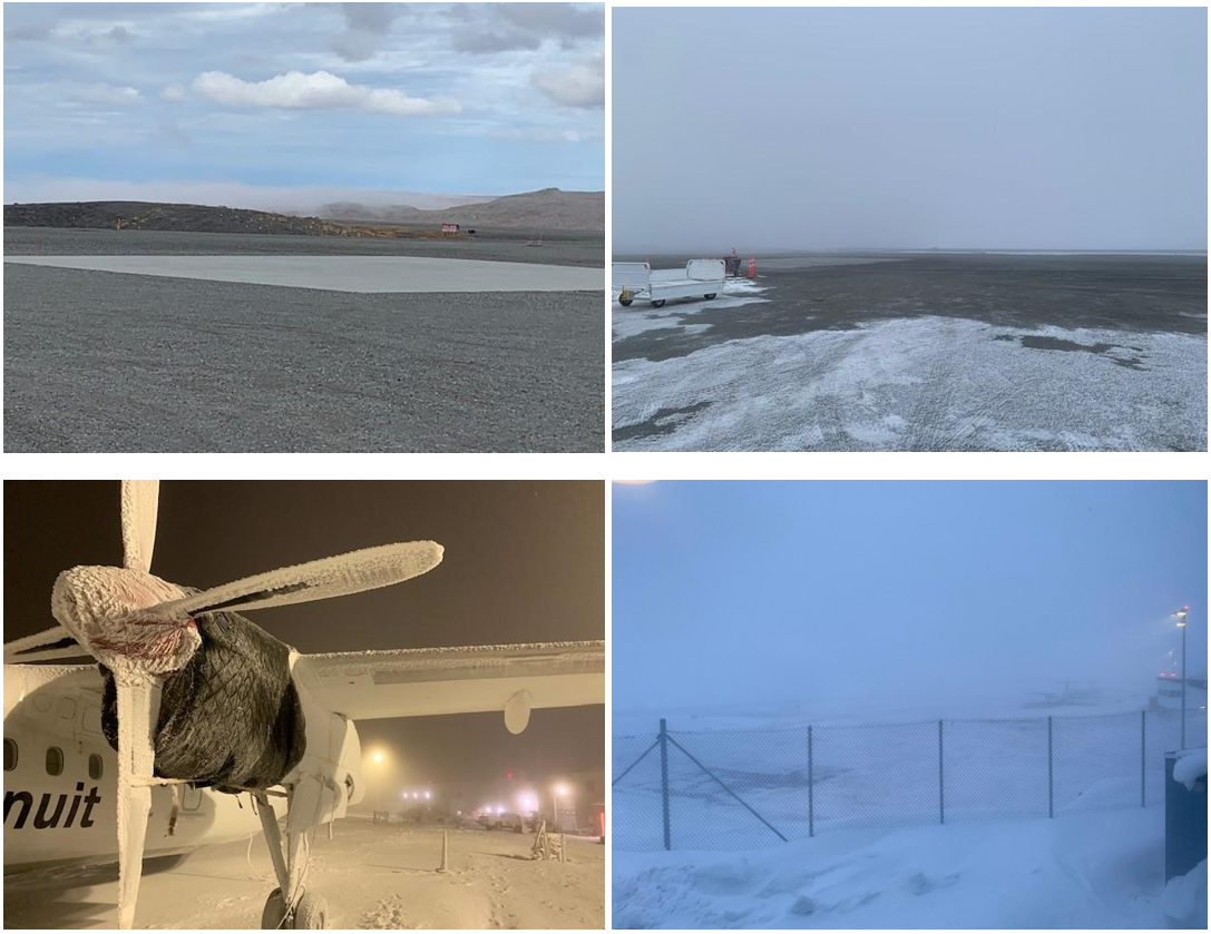
At CYAM (Sault-Ste-Marie, ON) fog is major in the spring and fall. Reduced visibility requires extra caution moving vehicles and aircraft around the field. Because CYAM is surrounded by water on 3 sides we often get fog over half the field and not the other half. Poor weather observations and forecasting of fog can result in unplanned reductions in serviceability.
Fog, in Aviation, basically means a ground-based cloud layer which obstructs Visibility to ½ SM or less (METAR abbreviation FG).
Mist (METAR abbreviation BR) is the reporting term used to describe a ground-based cloud layer that obstructs visibility to greater than ½ SM, but less than 6 SM. A related data point here is dewpoint depression (or spread). A specialist monitors this information at a properly equipped Weather Observing Site and can in this way verify the obstruction to visibility as being mist, versus another hydro or lithometeor (drizzle/haze/smoke/dust, etc).
This is vitally important information, because the presence of mist or fog in sub-zero weather also infers icing, potentially adversely affecting all airframes and carburetor-equipped aircraft in the area.
Fog has another important impact on flight operations. Good visibility is essential to Visual Flight Rules Operations in general, and IFR Operations during the departure and arrival phases (and taxiing as well, under very low visibility). Anything which restricts visibility is going to be of interest to all pilots.
The formation of fog or mist can take several paths. The mechanism of formation can be roughly equated with the intensity and duration of the phenomenon at the observation point. Frontal or advection fog tends to be thicker in density and longer in duration (hours or even days), versus radiation fog, which forms “pools” in low open ground under clear skies and dissipates in minutes or hours once sunlight reaches the surface of the earth. Upslope fog can last as long as the wind and temperature/dewpoint spread support it.
FIC
These different characteristics will define how an FSS briefs a pilot of the threat – i.e. if there is some radiation fog at the destination airport giving IFR conditions at the time of departure, a Specialist may be able to tell the pilot that by the time they arrive overhead their destination, it will be CAVOK. If there is a warm front arriving over the destination, though, the duration and density of frontal fog make this a potential “showstopper” for VFR pilots and maybe even IFR flights. There are other variables which come into play, but these examples illustrate the main differences of interest to Aviation Support staff.
AAS
As mist/fog can often be affected by local effects, and minute shifts in wind and temperature, Advisory Specialists are always very attentive when BR/FG is occurring, especially when the temperature is near or below freezing.
Fog has a large impact on ATC operations. When visibility is extremely low and the corresponding RVR dips below company thresholds, aircraft cannot land at airports and must hold. This is not complex on its own, but the main issue that arises with fog and low visibility are that different airlines have different minimums for flying approaches. Sometimes within a company, one aircraft can land at an airport with low visibility while an identical aircraft cannot (depending on pilot qualifications.) This makes for difficult sessions for air traffic controllers as we need to question everyone on what their minimums are and then pass them in front or clear them out of the way for aircraft who can land. The lack of consistency and the unpredictability create very complex situations coupled with rapidly changing conditions on the ground. For example, Pilot A informs ATC that they require 2600 RVR and 1/2SM visibility and Pilot B needs 1400 RVR and 1/4SM visibility. The conditions on the ground are 2800 RVR, so both aircraft can land. Conditions then deteriorate and drop to 2000 RVR. Pilot A needs to be removed from the ATC sequence so pilot B can fly an approach.
Hourly observations are closely scrutinized with the temperature and dewpoint spread being a key dynamic, although onshore wind and visibility is also considered. Oftentimes a potential alternate will not be considered when the dewpoint depression is close as it can be an indication of unforecast fog. Forecaster notes can often help in cases like this but there are limited amounts of TAF’s that support this feature. In those cases dispatchers are likely to reach out to the CMAC forecaster to gain additional required insight on the forecast.
Other weather forecasting tools used:
Fog will present significant operational difficulties. Generally our biggest concern is fuel for holding, approaches, and alternate airport diversions. Different countries often have other criteria for takeoff and landing.
An observation from a Canadian Airline:
“A single diversion created by fog, can have a snowball effect where the aircraft that diverted is no longer able to operate its next flight and the airline must make changes to this aircraft routing as it did not arrive at its destination. Subsequently, the outbound flight will now be delayed. This or else the airline will have to ferry an aircraft with a new crew to operate the next flight out."
Operations in northern regions can be particularly challenging as weather observations, and terminal forecasts are not as available. Often times, webcams, pireps and local company staff are the only way to know whether fog is present.
Observation from a Northern Operator:
“Fog is a major player in the Nunavik operation. With all airports located along the coast, fog banks will be present over the bay, close to the coast and any changes in the wind (direction and/or speed) could drastically change the weather. Ice and advection fog can be thick and have a serious impact on the operation. As there is no reliable forecast in this area, wind direction, spread between temperature and dew point, PIREP and strong knowledge of the region are our main tools to forecast how fog will affect our operation.”
VFR General Aviation (GA) pilots can be significantly affected by fog given that it reduces visibility well below minimum legal limits, leading to delays and/or cancelled flights. Fog can be variable and unpredictable once it sets in and even if it appears to be dissipating, it can reoccur under certain conditions. It can also occur on a very small scale (example: a lake), which can have significant impacts for VFR float planes but due to how small the feature may be may not be captured in forecast products. For this reason, it is important to look at the factors contributing to the formation and predicted dissipation of fog, information that could be received from a FIC weather briefing. This is also where PIREPs become invaluable. Having information, especially in/over regions that do not have TAFs or observations, can provide pilots, forecasters, and FIC specialists with a better understanding of where this phenomenon is occurring.
TAF, GFA are often used to predict fog and to a GA pilot often flying away from larger airports, the GFA can sometimes be more helpful because it describes conditions over a larger area than the TAF might not account for, but which might still affect the airport or area you will fly in. Auto observations can help a lot, as well as webcams for these airports. In addition to predictions for fog directly, pilots should be aware of the conditions that can produce fog (Temperature/dewpoint spread, wind, temperature history, geography, etc) and to be on alert for those conditions, even when fog is not predicted.
Fog seriously impacts visibility, so little difference is made between PROB/TEMPO/FROM if using the TAF product alone, that is why a good GA pilot will consider the products and factors described above. For GA flights and flight training, fog can lead to flight cancellations (loss of income) or diversions (increase in operating costs).
Impacts also vary based on the type of fog and how well it can be forecast. Understanding the risks and the type of fog forecast (radiation fog, advection fog, frontal fog) becomes important to VFR pilots, from both a flight planning and safety perspective.