METAR Code
N/A
Weather Symbol

Mountain waves are a type of mountain induced turbulence that occurs at or near the tropopause. They are caused by strong winds that encounter a barrier such as a mountain range, which forces the air upwards. As the air rises, it experiences compression and expansion, resulting in the formation of alternating regions of upward and downward motion. These upward and downward motions move vertically and horizontally, creating a series of waves in the atmosphere.
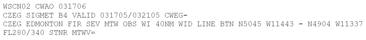
Mountain waves are more correctly called Vertically Propagating Mountain Waves, but are abbreviated to Mountain Wave or MTWV in aviation. They occur at similar altitudes to clear air turbulence however they are directly related to a mountain barrier so are stationary with respect to that barrier. They can occur with downslope windstorms, like chinooks, and may happen directly above a region of lower-level mechanical or lee wave turbulence.
Associated terms coming soon:
An inversion is a term also associated with mountain waves that will be coming soon to the Aviation Meteorology Reference.
For mountain waves to form, several ingredients are necessary. Firstly, strong winds flowing perpendicular or nearly perpendicular to a barrier such as a mountain range is necessary for mountain wave formation. Also, a particular stability profile that allows the air flowing across the barrier to rise is necessary for mountain waves to form and be sustained. Typically, a stable atmosphere (an inversion) at the same altitude as the mountain peaks is needed to generate mountain waves, as the stable air tends to be forced upwards as it encounters the barrier. Above the mountain peaks, a weakly stable to weakly unstable profile up to the tropopause is necessary. This allows the lower-level waves to move upward.
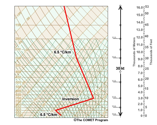
This image is a typical atmospheric profile that promotes the development of mountain waves. The profile shows an inversion between approximately 1 and 3km, with a temperature increase with height.
Image Source: COMETOpen a new window
Mountain waves begin when air flowing perpendicular to a mountain barrier is forced up and over the barrier. That flow combines with a very specific vertical stability profile to generate large waves in the lee, or downwind, of the barrier (an inversion around or just above the mountain peaks). In the case of mountain waves, the atmosphere just above this inversion is weakly or neutrally stable, to weakly unstable, with little to no wind shear.
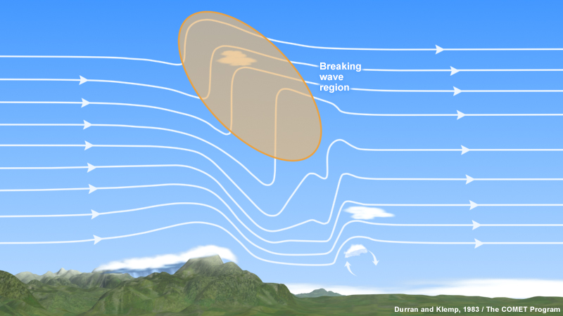
The stability in the atmosphere acts like a “ceiling,” allowing moisture, particulates, wind, and in this case waves to travel vertically or not. A stable atmosphere will not allow anything to move beyond it and acts to reflect the rising air back downward. With mountain waves, as the atmosphere is weakly stable to weakly unstable above the mountaintop, the waves generated here are allowed to travel vertically much higher than the mountain top until they “break” on the stable tropopause. Like where a river flows over a rock, this can create an area of severe turbulence above and just downstream of the mountain.
Mountain waves are associated with downslope windstorms like chinooks. They can produce rotors, standing lenticular clouds, and large cirrus shields known as a chinook arch.
This image is a diagram showing where the region of turbulence occurs (circled in orange) in the upper atmosphere due to mountain waves.
Image Source: COMETOpen a new window